Free Republic
Browse · Search
Bloggers & Personal
Topics · Post Article

Skip to comments.

NOAA/ERSL PSD AND CIRES-CU Maps. Question for weather nerds.
NOAA ^ | 2/16/16 | Rebelbase

Posted on 02/16/2016 7:32:10 AM PST by Rebelbase

I've googled and googled and cannot find an answer to this question.

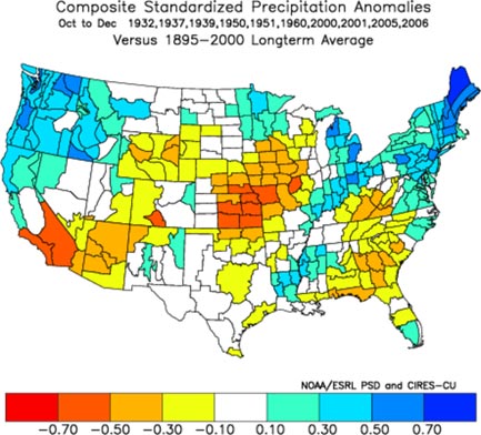
Joe Bastardi regularly refers to CIRES maps in his Saturday Summaries. The maps show geographic boundary divisions within each state that look like Counties but are not.

Does anyone know what these boundary divisions represent? Some sort of geographic climate designation?

Thank-you for your consideration!


TOPICS: Science; Weather
KEYWORDS: anotherstupidvanity
It's driving me crazy trying to figure this out.
1 posted on 02/16/2016 7:32:10 AM PST by Rebelbase
[ Post Reply | Private Reply | View Replies]

To: Rebelbase

My first thought is that they ARE in fact counties: Clusters of counties.


2 posted on 02/16/2016 7:34:47 AM PST by NowApproachingMidnight (Civilizations die from suicide, not murder.)
[ Post Reply | Private Reply | To 1 | View Replies]

To: Rebelbase

Map says Precipitation


3 posted on 02/16/2016 7:35:03 AM PST by Sacajaweau
[ Post Reply | Private Reply | To 1 | View Replies]

To: NowApproachingMidnight

Says precipitation....maybe watersheds


4 posted on 02/16/2016 7:37:16 AM PST by Sacajaweau
[ Post Reply | Private Reply | To 2 | View Replies]

To: NowApproachingMidnight

Looking at my state I see lines running though counties.


5 posted on 02/16/2016 7:37:55 AM PST by Rebelbase (Best election ever. Sick of it already, but best election ever.)
[ Post Reply | Private Reply | To 2 | View Replies]

To: Rebelbase

Here Ya go!

https://cires.colorado.edu/

https://en.wikipedia.org/wiki/Cooperative_Institute_for_Research_in_Environmental_Sciences


6 posted on 02/16/2016 7:43:44 AM PST by Conan the Librarian (The Best in Life is to crush my enemies, see them driven before me, and the Dewey Decimal System)
[ Post Reply | Private Reply | To 1 | View Replies]

To: Rebelbase
Cooperative Institute for Research in Environmental Sciences

It's at University of Colorado at Boulder

7 posted on 02/16/2016 7:46:32 AM PST by onona (Where are you tonight, my sweet Marie)
[ Post Reply | Private Reply | To 1 | View Replies]

To: Rebelbase

This:

http://www.esrl.noaa.gov/psd/data/usclimdivs/climdiv.help.html

Shows how they divide climate divisions.

I KNOW it’s not counties, cuz, I am in Georgia and we have 159 counties. The map only shows 9 divisions in Georgia.


8 posted on 02/16/2016 7:47:47 AM PST by Conan the Librarian (The Best in Life is to crush my enemies, see them driven before me, and the Dewey Decimal System)
[ Post Reply | Private Reply | To 1 | View Replies]

To: Rebelbase

http://cires.colorado.edu/


9 posted on 02/16/2016 7:48:43 AM PST by onona (Where are you tonight, my sweet Marie)
[ Post Reply | Private Reply | To 1 | View Replies]

To: Rebelbase

You might need to consider using some other search engine than leftwing google - first try result below.

Cooperative Institute for Research in Environmental Sciences
devoted to research and teaching in the wide-ranging disciplines of the environmental sciences.

cires.colorado.edu


10 posted on 02/16/2016 7:49:04 AM PST by PIF (They came for me and mine ... now it is your turn ...)
[ Post Reply | Private Reply | To 1 | View Replies]

To: NowApproachingMidnight
Each cluster of counties is served by a weather station.

For example, I live in Bay County, Florida. Our nearest full weather station is TLH (Tallahassee)

They put out forecasts for the entire CWA (County Watch Area) broken down into local forecast for each city/county area.

11 posted on 02/16/2016 7:52:22 AM PST by capt. norm (If you can't make them see the light, let them feel the heat!)
[ Post Reply | Private Reply | To 2 | View Replies]

To: Conan the Librarian

That helps some but it doesn’t mention any parameters that define the geographic divisions. I would think each geographic division within each state would have a name.


12 posted on 02/16/2016 7:56:06 AM PST by Rebelbase (Best election ever. Sick of it already, but best election ever.)
[ Post Reply | Private Reply | To 8 | View Replies]

To: Rebelbase

http://www.ncdc.noaa.gov/monitoring-references/maps/us-climate-divisions.php


13 posted on 02/16/2016 7:56:50 AM PST by stormer
[ Post Reply | Private Reply | To 1 | View Replies]

To: stormer; capt. norm

Excellent! Thank-you very much.


14 posted on 02/16/2016 8:02:51 AM PST by Rebelbase (Best election ever. Sick of it already, but best election ever.)
[ Post Reply | Private Reply | To 13 | View Replies]

To: stormer

Thanks again. It all makes sense now. NC, my home state is divided into eight regions. Northern and southern mountains, northern, central and southern piedmont and northern, central and southern coastal plain.


15 posted on 02/16/2016 8:05:41 AM PST by Rebelbase (Best election ever. Sick of it already, but best election ever.)
[ Post Reply | Private Reply | To 13 | View Replies]

Disclaimer: Opinions posted on Free Republic are those of the individual posters and do not necessarily represent the opinion of Free Republic or its management. All materials posted herein are protected by copyright law and the exemption for fair use of copyrighted works.

Free Republic
Browse · Search
Bloggers & Personal
Topics · Post Article

FreeRepublic, LLC, PO BOX 9771, FRESNO, CA 93794
FreeRepublic.com is powered by software copyright 2000-2008 John Robinson