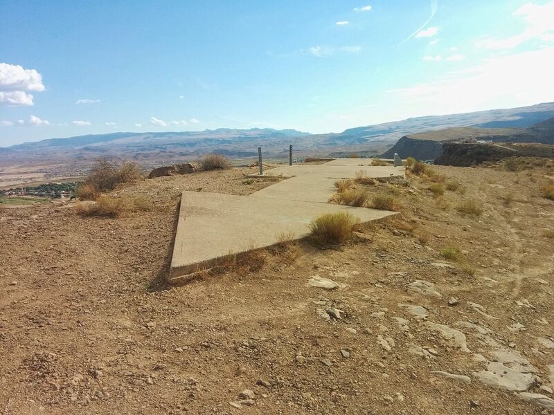
The remnants of Transcontinental Air Mail Route Beacon 37A, which was located atop a bluff in St. George, Utah. (Photo: Dppowell/Wikipedia)
Posted on 07/07/2015 1:40:59 PM PDT by NYer
The remnants of Transcontinental Air Mail Route Beacon 37A, which was located atop a bluff in St. George, Utah. (Photo: Dppowell/Wikipedia)
Across the United States, from Los Angeles to New York, lies a network of mostly forgotten infrastructure, a system that was obsolete before it was ever finished—forgotten relics from the early days of powered flight.
The early 20th century was an era of American history where Manifest Destiny seemed, well, manifest. The West had been won, and the cities blossomed. But with innovation came change and obsolescence. Trains became the prime movers of not only people and goods, but also the mail. The Pony Express proved the value of a trans-continental postal system in the United States, but the service was quickly usurped—the completion of the telegraph lines from East to West in 1861 saw it go out of business after just 18 months.
Our modern style of mail delivery, air mail, debuted less than eight years after powered flight. In 1903, the Wright brothers launched their Flyer at Kitty Hawk in 1903. On February 17, 1911, Fred Wiseman, an amateur pilot, carried three letters from Petaluma, California, to Santa Rosa, California, 18 miles away. The very next day, Henri Pequet delivered 6,500 letters from Allahabad, in northern India, to the city of Naini, located around eight miles away.
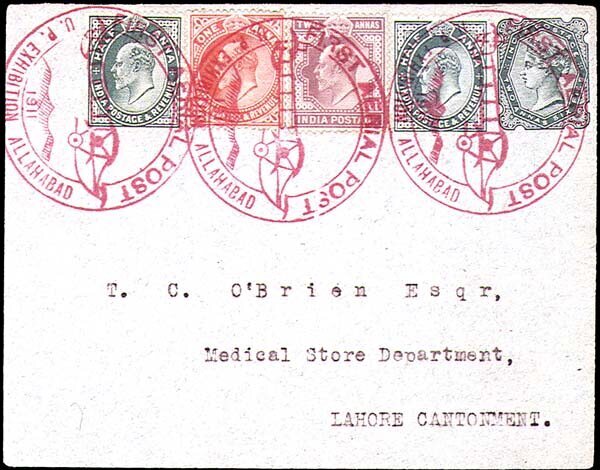
A letter that traveled on the 1911 flight from Allahabad. (Photo: Public domain on Wikipedia)
In 1914, the first long-distance airmail delivery was achieved. Between July 16th and 18th, Maurice Guillaux carried mail 584 miles, from Melbourne to Sydney. But it wasn't until 1918 that the east coast of the US got limited aerial postal deliveries. Two years later, the nation's transcontinental air mail route, stretching from New York to San Francisco, was flown for the first time.
Air travel and aviation in general was a difficult affair during the early twentieth century. Before the development of radio navigation, the primary method of flying across the United States was to travel along the rail routes, or "following the iron compass," as they called it at the time. As the railways usually connected population centers, they became the easiest way to navigate between cities and towns. But there needed to be other options.
Part of the solution was to establish concrete arrows, painted a brilliant yellow and embedded alongside 50-foot-high lighthouses (referred to in the aviation community as beacons) that shone out a route of light across the continental United States. Measuring up to 70 feet long, the arrows pointed in the direction of the next beacon-and-arrow, and were visible from a distance of 10 miles up.
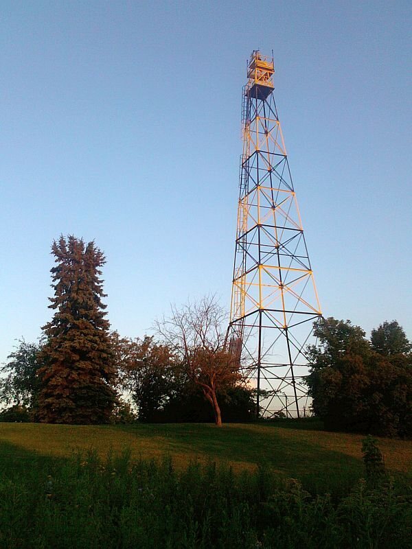
An airway beacon in St. Paul, Minnesota, built in 1929. (Photo: McGhiever on Wikipedia)
Before the beacons were put in place the mail-planes would land, and transfer their deliveries onto trains to travel overnight—reminiscent of the horse-and-rider swaps on the Pony Express. The beacons solved the problems associated with flying at night, but poor weather often led to the grounding of fleets and the mail being slowed. The beacons were, however, a huge step forward from the original approach: building huge bonfires next to airfields. ("Fatal accidents were routine" in those low-visibility times, notes the Federal Aviation Administration.)
With the development of radio navigation, the arrows and beacons started to become obsolete for the more sophisticated companies in the industry. At the same time, there was an explosion of private aircraft owners. The equipment needed for radio navigation was often out of the price range of these flyers, and also the airfields where they were landing. Most pilots did not know how to use radio navigation in that era, anyway.
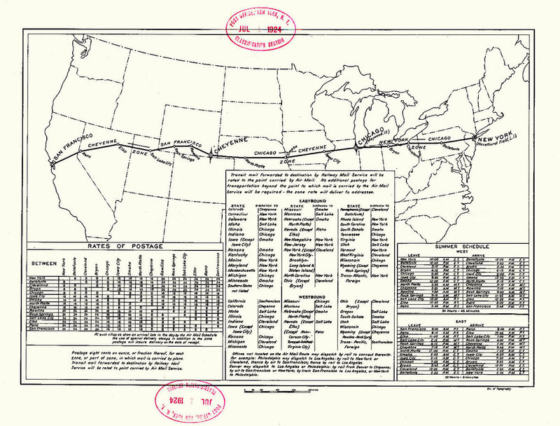
U.S. Post Office Department map of the First Transcontinental Air Mail Route. (Image: The Cooper Collection of Aero Postal History)
The arrow-and-beacon system proved incredibly popular with pilots, because not much could go wrong with giant concrete arrows on the ground. According to the Assistant Postmaster-General of the time, as quoted in the December 1923 issue of Popular Mechanics, there was a plan to build a similar system over the Atlantic. Yet, during the Second World War, the majority of the infrastructure was torn up, to stop the beacons from being used to provide directions to enemy bomber pilots. The metal used to build the towers was then redirected toward the war effort.
The concrete arrows, and some of the towers and sheds, still stand today. The state of Montana actually continues to use the system to help pilots navigate the rugged peaks of the region, as mountainous terrain can interfere with more sophisticated technological systems. Around nineteen of them are still in use. Here's a handy map of some of the surviving locations of these nearly-obsolete stone aviation arrowheads.
Fascinating.
There was one in the Arctic that actually was a disguised key for the Fortress of Solitude. You had to be pretty strong to pick it up and use it.
We used t’be the baddest ass on the planet .... ‘cause we COULD !
And pilots landed without navigation computers, glide slope indications, ILS beacons, and other aides. If they were too low the computer didn’t blare the message “warning terrain, pull up...” over and over.
That’s the second biggest arrow I’ve ever seen.
Darn, did not realize those guys putted along at 50,000 feet back then! Impressive.
Visible from 10 miles up . . . but they disappear when you get to 52,801 feet.
The “Shanghai Beacon” tower still stands on Third Hill Mountain in Berkeley Co, WV. I don’t remember seeing a concrete arrow next to it ... I’ll have to look next time I’m out that way.

I remember the new fangled Omni beacons that my girl friend told me about on my first long VFR flight assisting her in 1968. We had no radio, only a compass for Wichita to New Jersey so we couldn’t utilize them.
IBNLR
(In Before Nasca Lines Reference)
Wow! I wasn’t expecting to find my little hometown here in Indiana on that map. I’ll have to make a trip to the airport and check it out.
There were also things called blue and red airways. For night flying there were those colored beacons and you flew from one to another.
That's nothing.
L Ron Hubbard and Tom Cruise built these symbols to guide intergalactic aliens here to earth..........Trementina NM.
The Shelbyville Municipal Airport started as an emergency landing field in the 1930s for the Air Mail Pilots flying in the Light Beacon system. There was a light beacon tower sitting on a concrete arrow that guided pilots in the right direction. In the day time the arrows pointed the pilots to the next arrow. The arrows were spaced at about 10 mile intervals. At night, pilots simply followed the light beacons. There was an emergency grass landing strip located at the Shelbyville site. The concrete arrow is still in place on the Shelbyville Airport.
Gotta go to Greenfield next week.Will stop by there for
a look.Love stuff like this.
Wow !
Good job NYer
Thanks for a neat history lesson.
They also used to paint the name of the towns on warehouse roofs. Saved my butt one day.
Disclaimer: Opinions posted on Free Republic are those of the individual posters and do not necessarily represent the opinion of Free Republic or its management. All materials posted herein are protected by copyright law and the exemption for fair use of copyrighted works.