Skip to comments.
Mandatory evacuation for all areas affected by Agnes flood; river expected to reach 40.7 feet
Citizens Voice (Wilkes Barre PA) ^
| 9/8/11
| BOB KALINOWSKI
Posted on 09/08/2011 9:04:16 AM PDT by Born Conservative
click here to read article
Navigation: use the links below to view more comments.
first previous 1-20, 21-37 last
To: Palladin
I'm stranded by flooded roads here in the hills of northern Lebanon County.
I lost 3 trees to the fast moving creek water in my back yard.
This, after losing electricity for 5 days from Irene.
21
posted on
09/08/2011 11:37:14 AM PDT
by
airborne
(Paratroopers! Good to the last drop!)
To: airborne
That’s awful! Stay high and stay safe, and if you can’t—evacuate!
This flood is worse than Agnes!
22
posted on
09/08/2011 11:44:56 AM PDT
by
Palladin
(Sarah: Are you gonna fish or cut bait?)
To: Palladin
The creek runs thru the park. Evidently there was no time to get them out.
. All of Hershey is a flipping mess. It took me two hours to get home last night from Hershey to Fishing Creek Valley and two hours to get back into work this morning due to flooding on 322.
23
posted on
09/08/2011 1:01:34 PM PDT
by
linn37
To: linn37
Oh and 322 is closed at the Fort Hunter exit.You will not be going into Dauphin and points beyond. You will need to go across the river on 11/15.
24
posted on
09/08/2011 1:04:22 PM PDT
by
linn37
To: Born Conservative; All
Ok, putting the nap on hold, I had to go have a look !
Here are some pics from the Lewisburg area from about an hour ago.
Bear in mind that the Susquehanna won't crest til sometime tomorrow or Saturday, and at a significantly higher level than in these pics.
(click on these to see larger versions)
The first two were taken from the I-80 bridge over the Susquehanna, just a couple hundred yards from where the Interstate is closed to the east .. from the river to at least Bloomsburg.
Looking north at what is usually Rt.405 headed to Watsontown, but now totally submerged.
The traffic signs on the right stand about 8ft above the ground.

Next one is looking west toward the river.
The trees in the foreground just off the nose of my truck sit well back from the riverbank, and a good 8' above the water on a normal day.

This one is looking north from Market St. in Lewisburg at the old railroad bridge.
Normal river level is about 8-10ft below what you see on those piers .. well, the little bit of the piers you cansee.

The Market St. bridge crossing the river into Lewisburg from the east is closed.
This has prompted a celebratory atmosphere of folks gawping at the bazillion gallons of chocolate milk haulin' ass to the Chesapeake Bay.

25
posted on
09/08/2011 1:08:06 PM PDT
by
tomkat
(si vis pacem, para bellum)
To: tomkat
Same “party atmosphere on the bridge between Berwick and Nescopeck.
To: lightman
I was a pre-teen then, and remember both vividly (born in ‘63). Yes, there is infinitely more runoff now. In addition, the communities north of Wilkes Barre are screwed, as the levee doesn’t go up that far, causing the water that would have been in WB/Kingston to instead spread out further before it gets to the levee. I’ve been seeing pics of West Pittston (where I grew up), and the waters are already as high as Agnes, with more to come.
To: tomkat
Gee, I’m thinking “Maybe Ray Gricar’s body will surface.”
28
posted on
09/08/2011 6:12:50 PM PDT
by
Palladin
(Sarah: Are you gonna fish or cut bait?)
To: Palladin
LOL !
I was thinking the exact thing when standing close to that RR bridge.
Could see where his MiniCooper was parked when clicking the shutter.
'no tellin' what's gonna float up outta this mess'
29
posted on
09/08/2011 6:31:11 PM PDT
by
tomkat
(si vis pacem, para bellum)
To: Born Conservative
This is over...all the local “reporters” have lost that gleam in their eye. That seem nearly depressed.
30
posted on
09/08/2011 7:31:33 PM PDT
by
gilor
(Pull the wool over your own eyes!)
To: Pennsylvania; FReepers
31
posted on
09/08/2011 7:40:36 PM PDT
by
tomkat
(si vis pacem, para bellum)
To: All
I was just up there. Made it back to FL today. As I said on the other thread, I have never seen the Loyalsock so angry. Here is a picture of the collapsed Slabtown Bridge and what is left of Route 87 there:
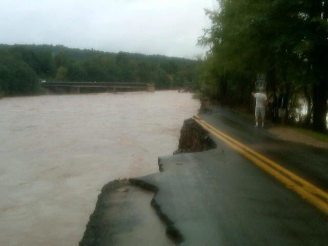
Here is another picture of Route 87:
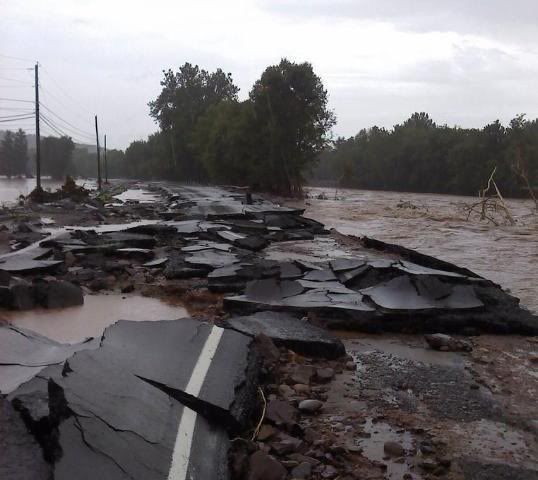
These pictures are from a friend of mine's facebook page. She has some others I'll post as well. Prayers to everyone along the River. Its like the Sock turned in to the Susquehanna and the Susquehanna is turning into the Mississippi.
32
posted on
09/08/2011 9:43:28 PM PDT
by
FlJoePa
("Success without honor is an unseasoned dish; it will satisfy your hunger, but it won't taste good")
To: Palladin; tomkat; Born Conservative
33
posted on
09/08/2011 10:49:34 PM PDT
by
agrace
To: FlJoePa
34
posted on
09/08/2011 10:51:46 PM PDT
by
agrace
To: All
Someone has a scary youtube video up of Slabtown Bridge. This guy is nuts.
The Sock
35
posted on
09/08/2011 11:06:10 PM PDT
by
FlJoePa
("Success without honor is an unseasoned dish; it will satisfy your hunger, but it won't taste good")
To: Born Conservative; All
36
posted on
09/09/2011 5:15:27 AM PDT
by
tomkat
(si vis pacem, para bellum)
To: Pennsylvania; All
According to
WNEP TV the Susquehanna crested at 38' overnight in Wilkes Barre, and so far the levees are holding.
37
posted on
09/09/2011 5:25:33 AM PDT
by
tomkat
(si vis pacem, para bellum)
Navigation: use the links below to view more comments.
first previous 1-20, 21-37 last
Disclaimer:
Opinions posted on Free Republic are those of the individual
posters and do not necessarily represent the opinion of Free Republic or its
management. All materials posted herein are protected by copyright law and the
exemption for fair use of copyrighted works.
FreeRepublic.com is powered by software copyright 2000-2008 John Robinson


