Posted on 09/07/2017 8:09:47 AM PDT by NautiNurse
its all about keeping the gasoline trucks coming in
Bastardi (on Hannity) :
“Right now..hurricane force winds start arriving on the south coast of Fla probably around noon on Sat and storm makes landfall very late Sat night some place between Key Largo and Miami-—that’s our estimate now.
“It travels up the east coast, gets back out over the water and then it comes after the Carolina’s and Georgia after that, so it will still be very, very powerful at that time.
....
“The problem is, where does it make that turn. If it makes that turn and comes up over Miami like I think it’s going to do and come back over water, we will be dealing with a major hurricane ever further up the coast-— up at Savannah and up into Charleston in that area, and that’s where our track is taking us.”
Bastardi will be on Hannity tomorrow night.
yes and he doesn’t engage in fake and raping refugee assistance

Hurricane-force winds extend outward up to 75 miles (120 km) from
the center, and tropical-storm-force winds extend outward up to 185 miles.
they r going to have to get military operations going on the higways and get people gas somehow...hate to hear that and I know this gov is doing all he can
That means Lake county will get 77 mph winds and the storm will be a CAT 2 north of Orlando.
I’m near Jax and last year for Matthew we had insane wind forecasts. Like 110 MPH for my zip on weather.com. I’m not getting anything like that for Irma. Highest I’ve seen is high 60’s MPH. But this storm seems so unpredictable. Who knows.
Gonna have a wild weekend!
Local forecast for my AO Sunday night
Heavy rain and strong winds from Hurricane Irma; heavy tropical rainfall will lead to flooding
Winds from the north at 79 MPH with gusts to 116.
https://www.accuweather.com/en/us/ocala-fl/34475/daily-weather-forecast/328163?day=4
Local government employees have taken more days off in September than they have worked.
ZCZC MIATCDAT1 ALL
TTAA00 KNHC DDHHMM
Hurricane Irma Discussion Number 36
NWS National Hurricane Center Miami FL AL112017
1100 PM EDT Thu Sep 07 2017
Microwave images and data from an Air Force Reserve Hurricane
Hunter aircraft indicate that Irma is developing a concentric
eyewall structure, and the plane reported an elliptical eye. The
highest flight-level and SFMR winds measured by the aircraft were
146 kt and 139 kt, respectively, so the initial intensity is lowered
slightly to 145 kt. Irma’s central pressure has fallen a bit
despite the slight reduction in winds, counterbalanced by an
expansion of the hurricane-force wind field as observed by the
plane.
If Irma has developed concentric eyewalls, then some additional
gradual weakening or fluctuations in intensity are possible over
the next day or two, despite a seemingly favorable atmospheric and
oceanic environment. The intensity models depict a very gradual
decrease in Irma’s maximum winds up until a possible landfall in
Florida, but the hurricane is nonetheless expected to still be at
or near category 4 strength at that time. After landfall, a fairly
quick decay in maximum winds is expected due to land interaction
and increased shear, although Irma’s large wind field is likely to
still produce hurricane-force winds over a large area.
Irma continues to move west-northwestward at 290/14 kt, steered by
the western extent of the subtropical ridge. Irma should maintain
this trajectory but slow down during the next 36 hours, and then
turn north-northwestward toward a break in the ridge by 72 hours.
Although there was a westward shift in the 18Z GFS, this model’s
new track puts it very close to the previous NHC forecast. As
such, no major changes to the NHC track were required on this
forecast through 72 hours, and the projected path lies between the
GFS and ECMWF, closest to the TVCN consensus and HCCA. After 72
hours, the models are showing a more pronounced turn toward the
northwest when Irma interacts with a shortwave diving southeastward
from the Central Plains, and the NHC forecast has been adjusted
accordingly at the end of the forecast period.
KEY MESSAGES:
1. Irma is a potentially catastrophic category 5 hurricane and will
continue to bring life-threatening wind, storm surge, and rainfall
hazards to the Turks and Caicos Islands and the Bahamas through
Saturday. Heavy rainfall is still possible across portions of
Hispaniola through Friday. Hurricane conditions will also
spread over portions of the north coast of Cuba, especially over
the adjacent Cuban Keys through Saturday.
2. Severe hurricane conditions are expected over portions of the
Florida peninsula and the Florida Keys beginning late Saturday.
Irma could make landfall in southern Florida as a dangerous major
hurricane, and bring life-threatening storm surge and wind impacts
to much of the state. A Hurricane Warning is in effect for southern
Florida, the Florida Keys, Lake Okeechobee, and Florida Bay, while
Hurricane Watches have been issued northward into central Florida.
3. A Storm Surge Warning is in effect for southern Florida and the
Florida Keys. A Storm Surge Warning means there is a danger of
life-threatening inundation, from rising water moving inland from
the coastline, during the next 36 hours in the indicated locations.
For a depiction of areas at risk, please see the National Weather
Service Storm Surge Watch/Warning Graphic, available at
hurricanes.gov. This is a life-threatening situation. Persons
located within these areas should take all necessary actions to
protect life and property from rising water and the potential for
other dangerous conditions. Promptly follow evacuation and other
instructions from local officials. A Storm Surge Watch has been
issued north of the Storm Surge Warning for portions of the central
Florida coast.
4. There is a chance of direct impacts in portions of Georgia,
South Carolina, and North Carolina, but it is too early to specify
the magnitude and location of these impacts.
FORECAST POSITIONS AND MAX WINDS
INIT 08/0300Z 21.3N 72.4W 145 KT 165 MPH
12H 08/1200Z 21.8N 74.4W 145 KT 165 MPH
24H 09/0000Z 22.3N 76.7W 140 KT 160 MPH
36H 09/1200Z 22.9N 78.6W 135 KT 155 MPH
48H 10/0000Z 23.7N 79.9W 135 KT 155 MPH
72H 11/0000Z 27.2N 81.1W 100 KT 115 MPH...INLAND
96H 12/0000Z 32.0N 83.5W 50 KT 60 MPH...INLAND
120H 13/0000Z 35.5N 86.5W 30 KT 35 MPH...INLAND
$$
Forecaster Berg
Thanks, thouworm:)
An incomprehensible storm.
Took my sister 10.5 hours to get from Ft Pierce to GA border. God knows what time she’ll get back to Jacksonville NC.
Took my sister 10.5 hours to get from Ft Pierce to GA border. God knows what time she’ll get back to Jacksonville NC.
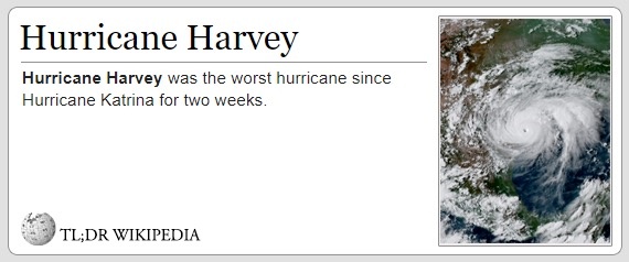
And before you think I’m being insensitive to people in harms way, I live in Houston and spent the better part of a week in Harris, Brazoria and Ft Bend counties performing boat rescues with my go-devil mud boat. I’ve knocked out Sheetrock, took a nail to the hand and now will deploy to assist post Irma. I’ve lived Harvey up close and personal for two weeks. This country cannot kill millions of babies and Thinkntjay God will just sit back and bless us.
And before you think I’m being insensitive to people in harms way, I live in Houston and spent the better part of a week in Harris, Brazoria and Ft Bend counties performing boat rescues with my go-devil mud boat. I’ve knocked out Sheetrock, took a nail to the hand and now will deploy to assist post Irma. I’ve lived Harvey up close and personal for two weeks. This country cannot kill millions of babies and Think that God will just sit back and bless us.
It is a friggin hurricane , not a plague, it is just weather. get over it.
Get lost.Hit the road.You need a new plan Stan.Hop on the Bus Gus.Reported.
Just leave the garbage outside, the wind should take care of it...
Disclaimer: Opinions posted on Free Republic are those of the individual posters and do not necessarily represent the opinion of Free Republic or its management. All materials posted herein are protected by copyright law and the exemption for fair use of copyrighted works.