What an unbelievable monster. I believe that Bucket Wheel machine was in Germany - most of these beasts are used for brown coal mining.

Posted on 02/12/2017 4:26:47 PM PST by janetjanet998
Edited on 02/12/2017 9:33:58 PM PST by Admin Moderator. [history]
The Oroville Dam is the highest in the nation.
FReeper mad_as_he$$ can give you his perspective on his view.... the intensity was such that the camera people were kept away at times as stakes & emotions were high in trying to salvage the situation (friendships, team,...). There are two sides to each story... felt there was more information to what built up to this that was not revealed (Dave had a reason for frustration towards this situation, just an unfortunate "slip" statement at the wrong moment triggered it).
What an unbelievable monster. I believe that Bucket Wheel machine was in Germany - most of these beasts are used for brown coal mining.
That thing looks like a crossbreed between a giant Tonka toy and a Transformer. :)
This link https://www.youtube.com/watch?v=nOnDeAIgUo8 is a short video of the construction of the dam. It shows that machine in operation. As add supposed,”They must have been classifying the aggregate prior to conveying to the dam site.” They mention that and you can see two conveyor belts.
This link is to a longer version. It has more info on the train and material placement. Worth watching to the end. BVB
https://www.youtube.com/watch?v=how56Jem9ZU
This video fits in with your post #2579...
https://m.youtube.com/watch?feature=em-subs_digest&v=OcjXPpRLSM4

fig 1
Flowing water cuts a "v" shaped profile into hillsides. Some of these profiles are highlighted in blue on this map:

fig 2
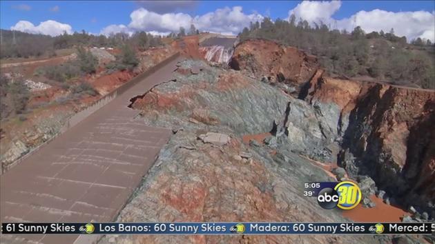
Here is an overall view of the complex prior to the emergency. The profiles highlighted in figure 2 are visible in this photo.

fig 3
This photo shows the heavily eroded area downstream from the emergency spillway.

fig 4
Several channels were cut.

fig 5
The channels in figure 5 correlate with the flows illustrated in figure 2 (channels A and C), and with a road (channel B-blue).

fig 6
So...
1) the topography was known, stream cuts are obvious
2) the geology was known, the weathered "rotten" rock was known
3) the emergency spillway is expected to be used
Water followed known paths. The erosion was foreseeable. It was foreseeable yet not mitigated. Why not?
Another question is, why is the erosion most severe at the head of channel B?
In figure 2 water to the left of the spillway runs roughly parallel to the spillway, takes a brief jog toward the spillway, and then moves progressively further from the spillway.
In figure 2 water to the right of the spillway runs roughly parallel to the spillway, bows sharply away from the spillway, and then returns to a roughly parallel course down to the river.
That's pretty much what happened:
**Assumptions: Term to identify where unanticipated alternate solution options were chosen where the decision(s) had a sense of a political tradeoff. "Political" in the sense of a decision that did not have the "scrutiny" of the engineering processes of the prior decisions. Whether this was done because of schedule reasons, cost reasons, plain assumption, or "being overruled" is not stated (not stated fully in the archives), but is recognizable by experienced engineers familiar with large & complex projects were command decisions occur.
I will post more on some key decisions and their significant impact on the MS & ES final design.
Political solutions are a huge issue when government takes on tasks that have real-world consequences down the road. It happens a lot, but usually with less risk. And it generally seems to happen well after the errant politician(s) are out of office.
I’m with TVA - we are quite the quasi-government outfit. I see stuff that is generally jaw-dropping. Then again, with Obama’s war on coal, I have the whole electric power industry do some jaw-dropping things.
When such entities encounter critical design issues, the dynamics of this "political sense of engineering" may result in consequential outcomes. THE MOST consequential outcome, for Oroville's Flood Control scheme, originated in the hydraulic fluid flow test studies. A huge problem forced a re-design of the original concept, that ultimately led to the design as it is today. From the series of events that followed, a decision tree may be traced that reveals a "political dynamic" in tradeoffs that occurred.

Another Juan Browne update video. In part of it, he explains the reason that the rock bolts are sticking out rather than counter-sunk...
https://www.youtube.com/watch?v=c16dr9qzlZY
Feb 22 , 2017
source: https://twitter.com/CA_DWR/status/834573813249486848
Mar 10, 2017
source: https://twitter.com/CA_DWR/status/840304624909266944
Continuing from a discussion:... "When such entities encounter critical design issues, the dynamics of this "political sense of engineering" may result in consequential outcomes. THE MOST consequential outcome, for Oroville's Flood Control scheme, originated from a crisis from hydraulic fluid flow test studies. A huge problem forced a re-design of the original concept, that ultimately led to the design as it is today. From the series of events that followed, a decision tree may be traced that reveals a "political dynamic" in tradeoffs that occurred."...
= =
The information below reveals the evidence of "political forms of engineering decisions" that resulted in a flawed total spillway design (true specs/performance) & violated the norms of high standards of dam engineering safety assurance. By simply "deeming" the use of a Weir based Emergency Spillway as "infrequent" and exceeding estimates of 10,000 yr maximum usage conditions, a "rationale was justified" to allow a "political solution" to introduce a significant design flaw in engineering judgement. This dangerous "rationale" justification propagated into other evidence of lesser importance consideration factors including non-anchoring of the Weir, non-concern for damaging erosion, no consideration to construct armor protection of the hillside, make the Weir long enough as needed to meet a flow "number", etc. All justified due to an introduced "reasoned minimal use" of a long Emergency Spillway Weir [6]. LEFT OUT of this "rationale" was the imperative safety necessity of REDUNDANCY in case of failure. i.e. The Main Spillway became supercritical in that any failure to the Main Spillway structure HAD NO backup (no redundancy as ES had high risk - unproven/tested [5]- and validated to be flawed) & that could risk the entire dam.
These type of "rationale" justified decisions, that lack a full comprehensive engineering thoroughness, is what leads to grand failures (in the politics of engineering judgement).
The Original Oroville Dam Spillway was presented to the public where it had a design capable of handling standard condition floods up to 440,000 cfs and worst case floods up to 720,000 cfs (reservoir inflow). As presented, the public could be assured that the design could handle worst case conditions such as the 1861-1862 MegaFlood. To meet this criteria, the flood control spillway was originally designed for a total 620,000 cfs flow using a massive "delta" set of combined gate structures of a "main" and "emergency" headworks. See the Artist's concept painting [1]. IN this design, there is NO erodible hillside flow spillway [2].
Then a Crisis occurred in scale model testing of this design. "Fins", "Standing Waves", and "monster splashing" (up to 100+ ft re: model scale) were becoming too challenging to resolve [3][4]. Turbulence and Eddy swirls aggravated the challenge. The cost of the fixes, in the fix design construction, was becoming more extensive from deeper rock excavation and higher concrete volume requirements. In the summation of these mounting design challenges, the California Department of Water Resources stepped in and made a "command decision" to break the combined design into two separate structures[5]; A main spillway with a separate Emergency Spillway Weir (as it is today & Failed at 12,000+ cfs [6]).
+Image [1] Original Design proposed to the public for funding - a combined high capacity spillway - Artist's concept painting.
+Image [2] Original Spillway design with Combined Flood structure - 620,000 cfs total capacity (370,000 cfs main flow + 250,000 cfs emergency flow).
+Image [3] Original Spillway model testing reveals "Fins", "Standing Waves", and "monster splashing" (up to 100+ ft re: model scale) @ 620,000 cfs total capacity (370,000 cfs main flow + 250,000 cfs emergency flow).
+Image [4] 3rd round of "fixes" in model testing still reveals challenges @ 620,000 cfs total capacity (370,000 cfs main flow + 250,000 cfs emergency flow).
+Image [5] California Department of Water Resources steps in and makes a "command decision" ("political engineering") when faced with this design crisis challenge.
+Image [6] Failure is introduced from the "a political engineering decision" with flawed rationale/justification (excludes full scrutiny in engineering thoroughness).
Image [1] Original Design proposed to the public for funding - a combined high capacity spillway - Artist's concept painting.

Image [2] Original Spillway design with Combined Flood structure - 620,000 cfs total capacity (370,000 cfs main flow + 250,000 cfs emergency flow).

Image [3] Original Spillway model testing reveals "Fins", "Standing Waves", and "monster splashing" (up to 100+ ft re: model scale) @ 620,000 cfs total capacity (370,000 cfs main flow + 250,000 cfs emergency flow).

Image [4] 3rd round of "fixes" in model testing still reveals challenges @ 620,000 cfs total capacity (370,000 cfs main flow + 250,000 cfs emergency flow). Note the "hand control angle experimentation" of vanes by engineers.

Image [5] California Department of Water Resources steps in and makes a "command decision" ("political engineering") when faced with this design crisis challenge.

Image [6] Failure is introduced from the "a political engineering decision" with flawed rationale/justification (excludes full scrutiny in engineering thoroughness).

I don’t know...something bothers me about the whole idea...
I have a problem with the concept of building something like that
and capturing that much emery and having no way of neutralizing it.
Like charging a capacitor with no way of grounding it,
or building a bomb with no way to defuse it.
I know they put two ‘bottom drains’ in the original design, but
they did not have the capacity to handle the river load,
and are currently non-functional.
Your analogy of the charged cap & live bomb is accurate. There cannot be any major flaws - especially in safety factor & redundancies. Losing a dam is not an option.

Yes, Oroville's Dam location, massive size/elevation & reservoir to flood control inlet elevations, creates a very significant energy potential. The hydro plant is not designed to handle an emergency situation to "neutralize" an accumulated reservoir head.
btw- Sinclair Dam is a perfect example -to compare to Oroville's ES specs- of a flood control gate structure designed for a total combined 240,000 cfs flow capacity (each gate is rated at/near 10,000 cfs). [Technically, the flood control gates would lower the lake/reservoir to the height of the lowest elevation of the flood control gate inlets. The hydro plant inlet is lower and its flow would further "lower the lake" below the flood gate inlets.]
Twice of what you saw flowing is 10,000 cfs short of Oroville's specified ES rating of 250,000 cfs. Imagine the hydraulic armageddon of the hillside and undermining of the Weir at the existing Oroville ES design...,
Back to Lake Sinclair...
From your description, the topology of the reservoir indicates that a significant amount of the shoreline dimensions & volume reduction capability occur from a "gate elevation" release perspective (surface area/volume reduction to the elevation of the flood control inlets). The Sinclair Dam flood control gates have the capacity to handle, in your terms, a "biblical outflow" - in matching a combined equivalent inflow. Since you observed just half of the capacity flow (assuming the starting water head elevation was at/near max) of 120,000 cfs, just imagine twice this flow if all 24 gates were opened (I believe your fishing holes -fish- may experience quite a "ride" i.e. become involuntary flying fish).
Disclaimer: Opinions posted on Free Republic are those of the individual posters and do not necessarily represent the opinion of Free Republic or its management. All materials posted herein are protected by copyright law and the exemption for fair use of copyrighted works.