Posted on 02/12/2017 4:26:47 PM PST by janetjanet998
Edited on 02/12/2017 9:33:58 PM PST by Admin Moderator. [history]
The Oroville Dam is the highest in the nation.
With liberals it is, an ounce of perception, a pound of obscure.
Here is a DWR video from yesterday that is a good overview:
https://www.youtube.com/watch?list=PLeod6x87Tu6eVFnSyEtQeOVbxvSWywPlx&v=yxgtyOfwrj8
Whoops, Saturday was the film date on that video.
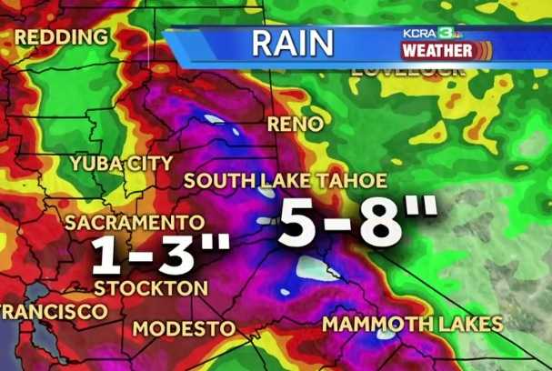
its appears the worst of the heavy rain will fall just south by about 50 miles
as long as the main spillway holds they should be fine
Thought I recalled reading about the public lies re published vs actual costs and the 'convenient' omissions re the various branches that would be needed eventually.
So to continue my WAG speculating, cynicism might be well directed toward the contractors involved and any (perhaps untraceable) kickbacks to the Brown cabal.
I keep imagining how great it would be, how much better off our Nation/world would be, if people as a rule cared about integrity, valued honesty, and played by the supposed rules . . .
</wishful thinking>
re: the Weather map
Approx where is Oroville Dam? Under the “A” in Yuba - under the “S” in Sacramento? about where?
just north if the C in Yuba City
Thanks. Local flooding from heavy rains pn saturated soil is causing all the local flooding right now. Just too much rain for some of the creeks and streams to carry. The situation with the Oroville dam is safe and sound right now, but I monitor it frequently. I dont want to be surprised ahain.
Good picture showing the emergency spillway was on native ground, not a component of the dam itself. There is not any problem with Oroville dam itself, or the stability of the emergency spillway on original ground. It was a concern that erosion could put the emergency spillway at risk, but it is not showing any instanility at this time. Now it is just a matter of the lake level never exceeding elevation 975’. That should keep us golden.

Quote with photo: If this picture was taken yesterday than the water is higher than then what they are saying already. Remember the water has been lowered over 50 feet. There is a rock wall below that grass on the left where those logs are at!
Thanks Lucy, but that quote with the photo is hard to decipher.
Dang...what a mess.
Hope he’s ok. Good kid.
When was pic in #1599 taken?
http://www.freerepublic.com/focus/news/3524221/posts?page=1599#1599
When was this pic taken?
http://www.freerepublic.com/focus/news/3524221/posts?page=1613#1613
http://www.sacbee.com/news/weather/article133818604.html#storylink=cpy
FEBRUARY 20, 2017 8:26 AM
Reservoirs feeding Lake Oroville are filled to brink as more rain rolls in
CHESTER
Lake Almanor is full. So is Antelope Lake.
In fact, all of the nine reservoirs in the Feather River watershed that feed directly into Lake Oroville are brimming with water from recent storms.
With more rain falling and another even heavier storm predicted for Monday and Tuesday, Plumas County officials are anxiously watching both the sky and the reservoirs above their communities.
(snip)
High in the headwaters above the ranches of Indian Valley, Antelope Lake holds around 27,000 acre feet of water. Operated by the California Department of Water Resources, Antelope is part of the State Water Project. It flows into a series of streams before emptying into Lake Oroville, which provides drinking water to more than 23 million people.
Last week, when ranchers and residents were flooded out of their homes in the valleys below, Antelope operators released 2,362 acre feet of water over six days. The largest single release – 714 acre feet – came on Feb. 10, when flooding across Indian Valley swept a Taylorsville resident off a bridge and into the creek near Crescent Mills. He survived.
Goss has not been contacted by DWR officials, he said, and has no information about how the Antelope releases affected his district.
DWR officials were preoccupied with the situation at Oroville and unavailable for comment on how they manage Antelope Lake. “I don’t even know where that reservoir is,” said DWR spokesman Chris Orrock, preoccupied with the situation at Oroville, where nearly 200,000 people were briefly ordered to evacuate last week amid fears that the dam’s emergency spillway would fail.
Antelope is one of nine reservoirs that provide water to Lake Oroville. Three are managed by DWR; one is operated by the South Feather Water and Power Agency. The other five are owned and operated by Pacific Gas & Electric Co., producing electricity as part of the Feather River Stairway of Power.
The largest of these is Lake Almanor near Chester. It stores 1,142,000 acre feet, around one-third of the storage capacity of Lake Oroville.
Don Pedro Reservoir Flood Gates Set To Open For First Time In 20 Years
February 20, 2017 11:59 AM
TUOLUMNE COUNTY (CBS13) – For the first time in 20 years, the Don Pedro Reservoir in Tuolumne County is in danger of flooding.
At 830 feet, the reservoir will flood. Right now, it’s at 826 feet. With heavy rains expected over the next few days, the controlled spillway gates will be opened Monday at 3 p.m., according to a Turlock Irrigation District official.
The last time gates were opened was in 1997.
The Tuolumne River runs from the reservoir into the city of Modesto.
           Station Name    ID     Date/Time            Value
INFLOW     OROVILLE DAM    ORO    02/20/2017 06:00     45518 CFS
OUTFLOW    OROVILLE DAM    ORO    02/20/2017 06:00     59685 CFS

INFLOW     OROVILLE DAM    ORO    02/20/2017 13:00     58023 CFS
OUTFLOW    OROVILLE DAM    ORO    02/20/2017 13:00     59889 CFS
INFLOW http://cdec.water.ca.gov/cgi-progs/getAll?sens_num=76
OUTFLOW http://cdec.water.ca.gov/cgi-progs/getAll?sens_num=23

from this morning when I posted that the main rain storms were going over the Folsom drainage instead of Oroville, it has now widened out and the fire hose has swung north and the Oroville drainage basin is in the main path.
Disclaimer: Opinions posted on Free Republic are those of the individual posters and do not necessarily represent the opinion of Free Republic or its management. All materials posted herein are protected by copyright law and the exemption for fair use of copyrighted works.