
Tropical weather ping!
Cue Arthur’s theme song, “The Best That You Can Do”
by Chris Cross
https://www.youtube.com/watch?v=G4rT9C5aV5A
Arthur he does what he pleases...
As we all know, tropical storms and hurricanes did not occur before global warming.
Libs already screaming and pulling their hair out.
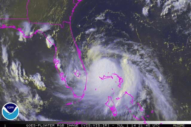
Latest discussion (doesn’t look real good for Hatteras if it strengthens more than they think - which is what Bastardi believes):
000
WTNT41 KNHC 011502
TCDAT1
TROPICAL STORM ARTHUR DISCUSSION NUMBER 3
NWS NATIONAL HURRICANE CENTER MIAMI FL AL012014
1100 AM EDT TUE JUL 01 2014
Radar and satellite imagery indicate that the convective
organization of the cyclone has improved since the previous
advisory, and the cyclone is being upgraded based on a sustained
wind report of 33 kt from Settlement Point (SPGF1) on Grand Bahama
Island earlier this morning that was outside of the deep convection.
After remaining nearly stationary earlier this morning, Arthur
appears to to be drifting northwestward now with an uncertain motion
of 315/02 kt. Otherwise, there is no significant change to the
previous forecast track. The latest model guidance has continued the
trend of a pronounced mid-tropospheric trough digging southeastward
from the upper-midwest into the northeastern and mid-Atlantic region
of the United States by 72 hours. The 500 mb flow pattern is almost
identical in the GFS and ECMWF models, which increases the
confidence in this evolving pattern. As a result, a steady increase
in southwesterly steering flow over the southeastern United States
is expected to gradually turn the tropical cyclone northward over
the next 24-36 hours, and then accelerate the system faster toward
the northeast on Thursday and Friday. By Days 4 and 5, Arthur is
forecast to move over the far north Atlantic as an extratropical
cyclone. The NHC track forecast is just an update of the previous
advisory track, and lies down the middle of the tightly packed
guidance envelope close to the consensus model TVCA.
Northwesterly vertical wind shear is forecast by the models to
gradually subside over the next 48 hours, which should allow the
cyclone to develop its own upper-level outflow pattern. In fact,
latest visible and water vapor imagery indicates that cirrus
outflow has been expanding on the north side of the system during
the past few hours, suggesting that the shear conditions could
already be subsiding. The low shear conditions and warm
sea-surface temperatures should allow for at least steady
strengthening, and the cyclone is expected to become a hurricane by
72 hours. The official intensity forecast is similar to the
latest intensity model consensus IVCN through 36 hours, and then
slightly higher after that.
FORECAST POSITIONS AND MAX WINDS
INIT 01/1500Z 27.6N 79.3W 35 KT 40 MPH
12H 02/0000Z 27.8N 79.4W 35 KT 40 MPH
24H 02/1200Z 28.7N 79.6W 40 KT 45 MPH
36H 03/0000Z 29.8N 79.5W 50 KT 60 MPH
48H 03/1200Z 31.2N 78.9W 60 KT 70 MPH
72H 04/1200Z 35.4N 75.2W 70 KT 80 MPH
96H 05/1200Z 40.8N 67.3W 65 KT 75 MPH
120H 06/1200Z 45.5N 59.5W 45 KT 50 MPH...POST-TROP/EXTRATROP
$$
Forecaster Stewart
Oddly, there are two UNNAMED storms off the West Coast. One of them is bigger than this one.
See for yourself: http://earth.nullschool.net/#current/wind/surface/level/orthographic=-78.00,8.24,1088
Now, when Arthur fizzles and only manages to dampen our July 4th weekend, but Bertha (or Barbara or Bunny or Belinda) wreaks havoc in a few weeks, the FemiNazis will screech that you name all the bad storms for women!
NOAA has decided to honor Dudley Moore this summer.
Next hurricane; Bo
It got a male name! Ohhhh, we’re all so scared we’re gonna run and hide and not get hurt.
Good thing it don’t got a female name, or we wouldn’t care and we wouldn’t take shelter and we all gon get killed.
July 4 is a huge week for OBX businesses. Hate to see them take a hit during this time.
Between this storm and the NPS restricting beach driving (impacts fall fishing season) the Bankers have a tough row to hoe this year.
Awful Arthur is coming. New York should evacuate NOW! There might be....rain, and wind!!
“1st named storm of the Atlantic season”
Which means that it’ll be the first storm blamed on global warming, uh, I mean “climate change”.
11PM Discussion:
000
WTNT41 KNHC 020252
TCDAT1
TROPICAL STORM ARTHUR DISCUSSION NUMBER 5
NWS NATIONAL HURRICANE CENTER MIAMI FL AL012014
1100 PM EDT TUE JUL 01 2014
Data from the Melbourne WSR-88D radar indicates that Arthur has a
complex structure this evening. A mid-level cyclonic circulation
accompanied by a possible eye feature is clearly evident near 27.8N
78.8W. However, the motions of the light showers/low clouds seen in
the radar data suggest that the low-level center is about 25-30 n mi
west of the mid-level center. Air Force Reserve and NOAA Hurricane
Hunter aircraft are scheduled to investigate Arthur early Wednesday
morning to see if the center has re-formed to the east. Pending the
arrival of the aircraft, the initial intensity remains 45 kt.
The initial motion is a rather uncertain 360/2. The track guidance
models remain in good agreement on a large mid/upper-level trough
digging southeastward into the northeastern and mid-Atlantic states
during the next 72 hours, while a subtropical ridge east of the
Carolinas gradually strengthens. The combination of these two
systems is expected steer Arthur generally northward for 24 hours or
so, followed by a turn toward the northeast and gradual
acceleration. The combination of the lack of motion over the past
6-12 hours and the slightly more eastward initial position have
resulted in some eastward shift of the track guidance envelope. As
a result, the new forecast track is also shifted slightly to the
east from the previous forecast. The official forecast is near the
center of the track guidance envelope and remains close to the
various consensus models.
Arthur is expected to be in an environment of light northwesterly
vertical wind shear for the next 60-72 hours. This should allow for
continued development. However, satellite total precipitable water
data suggests that pockets of dry air remain near the cyclone, and
these could hinder development. Given these competing factors, the
new intensity forecast is changed little from the previous forecast
and calls for Arthur to become a hurricane in about 36 hours and
reach its peak intensity in about 72 hours. After that time, the
cyclone should undergo extratropical transition and weaken as it
merges with the mid/upper-level trough.
Based on the new forecast track, additional watches and warnings
are not necessary for the North Carolina and South Carolina coasts
at this time. However, tropical storm or hurricane watches will
likely be required for portions of these areas on Wednesday.
FORECAST POSITIONS AND MAX WINDS
INIT 02/0300Z 27.9N 79.2W 45 KT 50 MPH
12H 02/1200Z 28.6N 79.3W 50 KT 60 MPH
24H 03/0000Z 29.7N 79.2W 60 KT 70 MPH
36H 03/1200Z 31.0N 78.7W 65 KT 75 MPH
48H 04/0000Z 32.8N 77.3W 75 KT 85 MPH
72H 05/0000Z 37.5N 72.0W 80 KT 90 MPH
96H 06/0000Z 43.0N 64.0W 60 KT 70 MPH...POST-TROP/EXTRATROP
120H 07/0000Z 47.5N 57.0W 45 KT 50 MPH...POST-TROP/EXTRATROP
$$
Forecaster Beven