Free Republic
Browse · Search
News/Activism
Topics · Post Article

Skip to comments.

Particularly Dangerous Situation (PDS) Tornado Watch 123 (IN, IL, MI, far NW OH), also AR, MO
NOAA ^ | 4/18/13

Posted on 04/18/2013 7:14:45 AM PDT by dirtboy

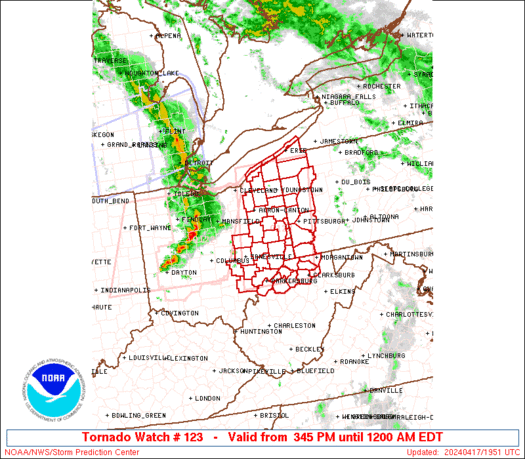
URGENT - IMMEDIATE BROADCAST REQUESTED TORNADO WATCH NUMBER 123 NWS STORM PREDICTION CENTER NORMAN OK 935 AM EDT THU APR 18 2013

THE NWS STORM PREDICTION CENTER HAS ISSUED A

* TORNADO WATCH FOR PORTIONS OF EASTERN ILLINOIS CENTRAL AND EASTERN INDIANA SOUTHERN LOWER MICHIGAN NORTHWEST OHIO OHIO LAKE MICHIGAN

* EFFECTIVE THIS THURSDAY MORNING AND AFTERNOON FROM 935 AM UNTIL 500 PM EDT.

...THIS IS A PARTICULARLY DANGEROUS SITUATION...

* PRIMARY THREATS INCLUDE... SEVERAL INTENSE TORNADOES LIKELY SEVERAL SIGNIFICANT DAMAGING WIND GUSTS TO 80 MPH POSSIBLE A FEW VERY LARGE HAIL EVENTS TO 2 INCHES IN DIAMETER POSSIBLE

THE TORNADO WATCH AREA IS APPROXIMATELY ALONG AND 75 STATUTE MILES EAST AND WEST OF A LINE FROM 65 MILES EAST NORTHEAST OF SOUTH BEND INDIANA TO 60 MILES SOUTH SOUTHWEST OF TERRE HAUTE INDIANA. FOR A COMPLETE DEPICTION OF THE WATCH SEE THE ASSOCIATED WATCH OUTLINE UPDATE (WOUS64 KWNS WOU3).

PRECAUTIONARY/PREPAREDNESS ACTIONS...

REMEMBER...A TORNADO WATCH MEANS CONDITIONS ARE FAVORABLE FOR TORNADOES AND SEVERE THUNDERSTORMS IN AND CLOSE TO THE WATCH AREA. PERSONS IN THESE AREAS SHOULD BE ON THE LOOKOUT FOR THREATENING WEATHER CONDITIONS AND LISTEN FOR LATER STATEMENTS AND POSSIBLE WARNINGS.

&&

OTHER WATCH INFORMATION...CONTINUE...WW 122...

DISCUSSION...DISCRETE SUPERCELL DEVELOPMENT IS POSSIBLE AHEAD OF THE INTENSIFYING PRE-FRONTAL SQUALL LINE THAT WILL RAPIDLY MOVE NORTHEASTWARD ACROSS THE WATCH AREA THIS MORNING. GIVEN THE STRENGTH OF THE LOW-LEVEL SHEAR...A FEW TORNADOES ARE POSSIBLE...BOTH IN SUPERCELLS AND WITHIN MESO VORTICES EMBEDDED WITHIN THE LINE. ACTIVITY MAY BE CAPABLE OF PRODUCING STRONG TO LOCALLY EXTREME WIND DAMAGE...REGARDLESS OF WHETHER TORNADIC OR STRAIGHT LINE IN NATURE,

AVIATION...TORNADOES AND A FEW SEVERE THUNDERSTORMS WITH HAIL SURFACE AND ALOFT TO 2 INCHES. EXTREME TURBULENCE AND SURFACE WIND GUSTS TO 70 KNOTS. A FEW CUMULONIMBI WITH MAXIMUM TOPS TO 500. MEAN STORM MOTION VECTOR 24050.


TOPICS: Extended News; News/Current Events; US: Arkansas; US: Illinois; US: Indiana; US: Kentucky; US: Michigan; US: Missouri; US: Ohio
KEYWORDS: tornadowatch; weather
Navigation: use the links below to view more comments.
first 1-2021-24 next last
Large section of the country under risk of severe weather today.
1 posted on 04/18/2013 7:14:45 AM PDT by dirtboy
[ Post Reply | Private Reply | View Replies]

To: dirtboy

2 posted on 04/18/2013 7:15:21 AM PDT by dirtboy
[ Post Reply | Private Reply | To 1 | View Replies]

To: dirtboy

We had hail in Indiana yesterday.


3 posted on 04/18/2013 7:15:54 AM PDT by gattaca ("Empty heads are fond of long titles" Old German Proverb.)
[ Post Reply | Private Reply | To 1 | View Replies]

To: dirtboy

I thought PDS was Palin Derangement Syndrome.....


4 posted on 04/18/2013 7:16:08 AM PDT by Uncle Miltie (Leftists favorite Mass Murderer: Kermit Gosnell)
[ Post Reply | Private Reply | To 1 | View Replies]

bump!


5 posted on 04/18/2013 7:17:20 AM PDT by trisham (Zen is not easy. It takes effort to attain nothingness. And then what do you have? Bupkis.)
[ Post Reply | Private Reply | To 1 | View Replies]

To: TheOldLady

Ping!


6 posted on 04/18/2013 7:17:55 AM PDT by trisham (Zen is not easy. It takes effort to attain nothingness. And then what do you have? Bupkis.)
[ Post Reply | Private Reply | To 5 | View Replies]

To: Springman; cyclotic; netmilsmom; RatsDawg; PGalt; FreedomHammer; queenkathy; madison10; ...
Eyes on the skies folks. The weather has that "feel" already.

Image Hosted by ImageShack.us

Michigan legislative action thread
7 posted on 04/18/2013 7:19:32 AM PDT by cripplecreek (REMEMBER THE RIVER RAISIN!)
[ Post Reply | Private Reply | To 1 | View Replies]

To: cripplecreek

might want to bump the MI ping list on this one.


8 posted on 04/18/2013 7:19:43 AM PDT by absolootezer0 (2x divorced tattooed pierced harley hatin meghan mccain luvin' REAL beer drinkin' smoker ..what?)
[ Post Reply | Private Reply | To 1 | View Replies]

To: dirtboy

Radar I’m using.

http://www.wilx.com/weather/interactiveradar


9 posted on 04/18/2013 7:21:19 AM PDT by cripplecreek (REMEMBER THE RIVER RAISIN!)
[ Post Reply | Private Reply | To 1 | View Replies]

To: absolootezer0
jumped the gun on that one.
10 posted on 04/18/2013 7:21:27 AM PDT by absolootezer0 (2x divorced tattooed pierced harley hatin meghan mccain luvin' REAL beer drinkin' smoker ..what?)
[ Post Reply | Private Reply | To 8 | View Replies]

To: cripplecreek
Another tornado watch for central MI:


11 posted on 04/18/2013 7:22:20 AM PDT by dirtboy
[ Post Reply | Private Reply | To 7 | View Replies]

To: dirtboy

We’re in a western suburb of Chicago. We had a few very tense minutes where the sky turned black and there were strong gusts. Our TV went out, and we’ve got lots of street flooding. At Mass there were only eight other people. Smallest crowd ever! All schools (and several stores) are closed too. More rain is on the way...


12 posted on 04/18/2013 7:22:23 AM PDT by mlizzy (If people spent an hour a week in Eucharistic adoration, abortion would be ended. --Mother Teresa)
[ Post Reply | Private Reply | To 1 | View Replies]

To: cripplecreek
And remnants of an earlier watch:


13 posted on 04/18/2013 7:23:48 AM PDT by dirtboy
[ Post Reply | Private Reply | To 9 | View Replies]

To: dirtboy

Its already pretty windy here in Southern MI.


14 posted on 04/18/2013 7:24:47 AM PDT by cripplecreek (REMEMBER THE RIVER RAISIN!)
[ Post Reply | Private Reply | To 11 | View Replies]

To: dirtboy

My wife is on a plane headed for (I hate to say it) chicago. It has been delayed twice, but is now headed into it.

As my flight instructor said, “Happy Landings!”


15 posted on 04/18/2013 7:26:02 AM PDT by Huebolt (A country that has tipped will fall. RIP USA)
[ Post Reply | Private Reply | To 2 | View Replies]

To: dirtboy

There’s a bit of eyebrow-raising and head-scratching from a few people on weather boards at the PDS watch.


16 posted on 04/18/2013 7:29:47 AM PDT by Strategerist
[ Post Reply | Private Reply | To 1 | View Replies]

To: Strategerist
And a watch down into Arkansas:


17 posted on 04/18/2013 7:30:40 AM PDT by dirtboy
[ Post Reply | Private Reply | To 16 | View Replies]

To: Strategerist

Yeah, they had a moderate risk of severe weather yesterday for Oklahoma and that never really materialized. Nothing currently on radar in the area that looks that bad.


18 posted on 04/18/2013 7:31:41 AM PDT by dirtboy
[ Post Reply | Private Reply | To 16 | View Replies]

To: Uncle Miltie

Pansy Dem Symptoms.


19 posted on 04/18/2013 7:34:11 AM PDT by ConservativeStatement (Obama is the "Disco Duck" president. A no-substance novelty that reached number one.)
[ Post Reply | Private Reply | To 4 | View Replies]

To: dirtboy
Those went through my area between 2 and 5 a.m. A couple of small tornadoes did touch down in NE Oklahoma (Spavinaw and se of Grove).

==


20 posted on 04/18/2013 7:52:57 AM PDT by TomGuy
[ Post Reply | Private Reply | To 1 | View Replies]


Navigation: use the links below to view more comments.
first 1-2021-24 next last

Disclaimer: Opinions posted on Free Republic are those of the individual posters and do not necessarily represent the opinion of Free Republic or its management. All materials posted herein are protected by copyright law and the exemption for fair use of copyrighted works.

Free Republic
Browse · Search
News/Activism
Topics · Post Article

FreeRepublic, LLC, PO BOX 9771, FRESNO, CA 93794
FreeRepublic.com is powered by software copyright 2000-2008 John Robinson