![]()
Posted on 04/16/2010 12:17:34 PM PDT by CedarDave
SUMMARY FOR POLICY MAKERS
(by SPPI)
1. Instrumental temperature data for the pre-satellite era (1850-1980) have been so widely, systematically, and uni-directionally tampered with that it cannot be credibly asserted there has been any significant “global warming” in the 20th century.
2. All terrestrial surface-temperature databases exhibit signs of urban heat pollution and post measurement adjustments that render them unreliable for determining accurate long-term temperature trends.
3. All of the problems have skewed the data so as greatly to overstate observed warming both regionally and globally.
4. Global terrestrial temperature data are compromised because more than three-quarters of the 6,000 stations that once reported are no longer being used in data trend analyses.
5. There has been a significant increase in the number of missing months with 40% of the GHCN stations reporting at least one missing month. This requires infilling which adds to the uncertainty and possible error.
6. Contamination by urbanization, changes in land use, improper siting, and inadequately-calibrated instrument upgrades further increases uncertainty.
7. Numerous peer-reviewed papers in recent years have shown the overstatement of observed longer term warming is 30-50% from heat-island and land use change contamination.
8. An increase in the percentage of compromised stations with interpolation to vacant data grids may make the warming bias greater than 50% of 20th-century warming. 9. In the oceans, data are missing and uncertainties are substantial. Changes in data sets introduced a step warming in 2009.
10. Satellite temperature monitoring has provided an alternative to terrestrial stations in compiling the global lower-troposphere temperature record. Their findings are increasingly diverging from the station-based constructions in a manner consistent with evidence of a warm bias in the surface temperature record.
11. Additional adjustments are made to the data which result in an increasing apparent trend. In many cases, adjustments do this by cooling off the early record.
12. Changes have been made to alter the historical record to mask cyclical changes that could be readily explained by natural factors like multi-decadal ocean and solar changes.
13. Due to recently increasing frequency of eschewing rural stations and favoring urban airports as the primary temperature data sources, global terrestrial temperature data bases are thus seriously flawed and can no longer be representative of both urban and rural environments. The resulting data is therefore problematic when used to assess climate trends or VALIDATE model forecasts.
14. An inclusive external assessment is essential of the surface temperature record of CRU, GISS and NCDC “chaired and paneled by mutually agreed to climate scientists who do not have a vested interest in the outcome of the evaluations.”
15. Reliance on the global data by both the UNIPCC and the US GCRP/CCSP should trigger a review of these documents assessing the base uncertainty of forecasts and policy language.
Check out the table of contents (entire document on line as a PDF).
PING!
![]()
http://www.surfacestations.org/
This graph shows a major problem
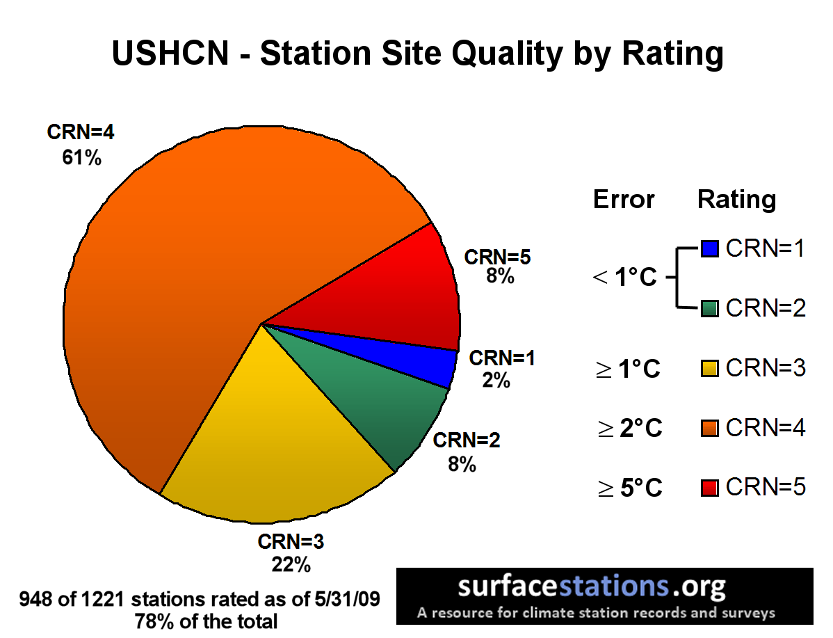
Yes 69% of data collection stations have a greater than 2C degree error.
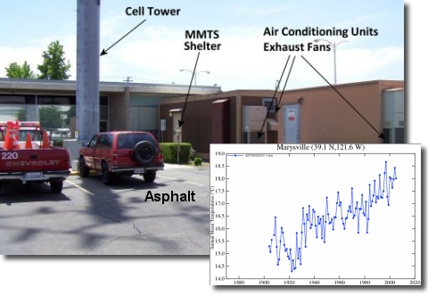
And pictures to show why
Nice...
btt
CRN4 and CRN5’s have artificial heat sources near or directly on temperature collection devices. Like asphalt, AC exhaust, metal siding, etc.
One in their odd and irregular site listings had aircraft parking less than 10 feet from the temperature gauge.
ping to file
A nice. concise summation. It’s also important to have some knowledge about data “smoothing.”
*******************************EXCERPT****************************************
Two years ago, Joe D'Aleo asked NCDC's Tom Karl about the problems with siting and why they could not speed up the plans for a Climate Reference Network (CRN - at that time called NERON).
He said he had presented a case for that to NOAA but had it turned down with the excuse from high levels at NOAA that the surface stations did not matter because we had satellite monitoring.
The Climate Reference Network was capped at 114 stations but will not provide meaningful trend assessment for about 10 years.
NOAA has recently reconsidered and now plans to upgrade about 1000 climate stations, but meaningful results will be even further in the future.
In monthly press releases no satellite measurements are ever mentioned, although NOAA claimed that was the future of observations.
**************************************************
Does Hansen even know there is Satellite monitoring.??
See #10.
For the reason see my post #18 on the other thread:
From page 71 of the report:
Satellite input was removed (Smith et al., 2008) by NOAA in July 2009 after complaints of a cold bias in the southern hemisphere. The immediate result was a sharp increase in ocean and ocean/land global temperatures. The result was that NOAA claimed that July and August 2009 had the warmest water temperatures on record, with a jump of about 0.24ºC. This added 0.15ºC to global mean temperatures.
Bookmarked...
Disclaimer: Opinions posted on Free Republic are those of the individual posters and do not necessarily represent the opinion of Free Republic or its management. All materials posted herein are protected by copyright law and the exemption for fair use of copyrighted works.
