Posted on 07/14/2016 1:06:38 PM PDT by JimSEA
A new GPS study of Bangladesh, India, and Myanmar (Burma) has found startling evidence that the northeastern corner of the Indian subcontinent is actively colliding with Asia, potentially posing a major earthquake risk to one of the world’s most densely populated regions.
A new GPS study of Bangladesh, India, and Myanmar (Burma) has found startling evidence that the northeastern corner of the Indian subcontinent is actively colliding with Asia, potentially posing a major earthquake risk to one of the world’s most densely populated regions.
The years-long analysis is the first to incorporate GPS data from Bangladeshi tracking stations. It is now the latest volley in a long-running academic debate over if and how the geologically complex region is seismically active.
YOU MIGHT ALSO LIKE Powerful Photos Show Enduring Devastation of Nepal Earthquakes Ecuador's Deadly Earthquake in Pictures See the Devastation Caused by the Recent Earthquakes in Japan If the new study’s models are correct, the region—home to more than 140 million people—could be sitting atop an active megathrust fault, the same kind of geologic feature that caused the catastrophic magnitude 9.0 earthquake in Japan in 2011.
What’s more, the models suggest that the fault is stuck and has been accumulating stress for more than 400 years, since before the Mughals made the Bangladeshi city of Dhaka the regional capital in the early 1600s.
(Excerpt) Read more at news.nationalgeographic.com ...
And there are such good construction protocols there.
OK. Its Population control.
Actually, the title of the article is extremely misleading as the subduction fault in question is a good fifty million years old. Newly studied by short lived humans would be better inserted in the title.
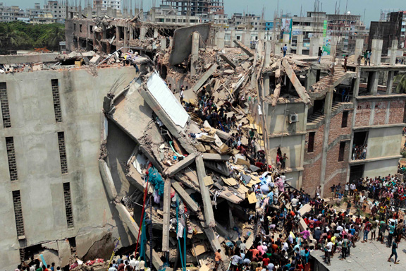
Quit a picture. Can you imagine the city after a 7+ earthquake?
Frightening.
Why not China? I was hoping...
After the 2004 Boxing Day earthquake and tsunami a Thai coworker went back home for a visit. On his return he told me the people there all blame the US for it because of all the oil drilling
Recorded human history only gives hints of the potential for an earthquake at this point in the subduction zone. On the surface there are no clear signs of the potential and extent of this fault zone because it is covered over by an alluvial plane. Studying and modeling the seismic record is the best way to approach an area like this.
Those people are standing directly under giant hanging concrete columns, shattered from their foundations. Where is their sense of self-preservation?
Johnny Cash, seismologist said it best: “And it burns, burns, burns, The Ring of Fire.”
Should we care?
If so, WHY should we care?
Pulled into a tire shop in Memphis that was right beside the railroad tracks. Across the tracks was a four story apartment building. People were throwing their trash out the window. The picture you posted reminds me of that experience.
Maybe because it’s a longshot, but because they are human beings?
I’m sure this “new” threat is caused by man made climate diddling or cow farts or whatever it is they call the scam these days.
Disclaimer: Opinions posted on Free Republic are those of the individual posters and do not necessarily represent the opinion of Free Republic or its management. All materials posted herein are protected by copyright law and the exemption for fair use of copyrighted works.