Posted on 07/01/2012 9:55:18 AM PDT by donna
During the pre-dawn hours on Sunday, July 4, 1999 thunderstorms were occurring over portions of the Dakotas. By 6 AM CDT some of the storms formed into a bow echo and began moving into the Fargo, North Dakota area with damaging winds.
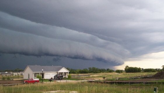
Thus would begin the "Boundary Waters - Canadian Derecho" that would last for over 22 hours, travel over 1300 miles at an average speed of almost 60 mph, and result in widespread devastation and many casualties in both Canada and the United States (Fig. 1). The following paragraphs describe what happened along the path of this long-lived international derecho.
...NORTH DAKOTA...
As the bow echo system formed over eastern North Dakota (ND) on the morning of July 4th, it quickly started to produce very severe, long-lasting winds. The storm winds reached Fargo's Hector Airport around 7:30 AM CDT. Winds in excess of 58 mph continued for 39 minutes, and a maximum gust of 91 mph was measured at 7:42 AM. Many planes at the airport were damaged or overturned, and hangers were damaged as well. In the Fargo metropolitan area, damage totaled more than $85 million (1999 U. S. dollars). Many roofs were damaged or blown off, and some buildings and garages were destroyed. Vehicles were damaged or overturned, and many trees and power poles were blown down. About 40,000 customers were without electrical power. Several people were injured.
(snip)
...MINNESOTA...
Severe wind damage continued to occur as the derecho moved across northern Minnesota (MN). The roof was blown off the public works building in Ada, and many buildings, mobile homes, and vehicles were damaged by the derecho winds and falling trees in Clay, Norman, Hubbard, and Beltrami Counties. Damage in Cass, Itasca, and Aitkin Counties exceeded 3 million (1999 U. S. dollars), and several campers were injured in the Walker-Leech Lake area. As the derecho entered St. Louis County, a wind gust of 81 mph was recorded at the Chisholm-Hibbing Airport, and the terminal building and hanger suffered damage. A semi-trailer truck was blown over on U.S. Highway 53 near Canyon, MN, just northwest of Duluth.
As the derecho raced into the Arrowhead region of northeast Minnesota during the early afternoon of July 4th, many casualties occurred despite the low population density of this heavily forested area. Because it was Independence Day weekend, many people had traveled to the Boundary Waters Canoe Area (BWCA) to enjoy canoeing and camping. Winds estimated at 80 to 100 mph moved rapidly through the area, causing serious damage to 600 square miles of forest in the Arrowhead region. Tens of millions of trees were blown down (Figs. 2 and 3). Sixty people in the BWCA were injured by falling trees, some seriously. Twenty of those injured were rescued by floatplanes flying to lakes located in the forest near the victims.
(snip)
...SUMMARY...
The very long-lived Boundary Waters-Canadian Derecho was one of farthest north "progressive" derechos to have been recorded. It traveled through a large part of the boreal forests of North America, uprooting and breaking off hundreds of square miles of trees. Two people were killed and 70 were injured. Almost all of the casualties (67) were the result of trees or tree limbs falling on the victims. Additionally, almost all of the victims were outdoors (e.g., camping, hiking, or canoeing). This includes one casualty that was not the result of a falling tree (or limb); this person's death was due to drowning after having been blown off a boat. Drownings are another cause of death most frequently associated with warm-season derechos.
Most of the damage to homes and businesses occurred in areas of higher population density such as near the beginning of the event in the Fargo, North Dakota metropolitan area, and near the end of the event over parts of south central and southeast Quebec (Fig. 1). It was these areas that contributed the most to the recorded property damage that exceeded $100 million in 1999 U.S. dollars --- and to the total of over 700,000 households and businesses that lost electrical power from the long-lived derecho.
The current Derecho:
What is a Derecho? (With Timelapse Video)
June 29, 2012
Ring of Fire Derecho (Ref + Velocity Two Panel)
http://www.youtube.com/watch?v=W3fQNLAMT4o
Why have the meteorologists in about the last 50 years decided to give all weather phenomena foreign names?
I think it started by renaming tidal waves ‘tsunamis’. Last years effort was to call dust storms ‘simoons’, which was both silly sounding and elicited a big huh? from everyone who was used to calling a dust storm a dust storm.
And they’re never satisfied. It took a few decades for people to adjust to the idea of the word ‘monsoon’ in the southwest, which comes in the first week of July bringing higher humidity and little else other than dust storms.
But now they’ve decided to downgrade ‘monsoon’ from a definite event to sort of “midsummer”. They will probably give it a different name that sounds silly. “But that is what they call it in Yemen!”, is hardly a good rationale.
Until the other day, I'd never heard of a "Derecho." Very, very interesting.
I leaned of it when I read the book “Northwest Angle” from the Cork O’Connor series written by William Kent Krueger.
The Northwest Angle is part of Minnesota - the only place in the US outside Alaska that is north of the 49th parallel. The Angle is not directly connected by land to the rest of the US.
To this location he added a Derecho. I learned all kinds of stuff.
Disclaimer: Opinions posted on Free Republic are those of the individual posters and do not necessarily represent the opinion of Free Republic or its management. All materials posted herein are protected by copyright law and the exemption for fair use of copyrighted works.