Skip to comments.
So actually, Apple isn't recording your (accurate) iPhone location ( with photo maps)
Geothought blogspot ^
| April 23, 2011
| Peter Batty
Posted on 04/24/2011 11:02:16 PM PDT by Swordmaker
So over the past couple of days there has been mass hysteria, questions in Congress, etc, over the fact that Apple is apparently recording all the locations you've been to with your iPhone without telling you, and storing it without encryption. The news was broken by my friend Pete Warden at Where 2.0 last week and has escalated rapidly since then. As someone who publishes their location anyway (you can see where I am right now by checking the right hand panel on my blog) I was less concerned about this than many, though I agree that Apple should make it clear that they are recording this information and give you the option to turn it off, plus it should be stored more securely.
However, yesterday Sean Gorman posted that he had analyzed his data, and the interesting thing is that it wasn't accurate - it showed the general areas he'd been to, but didn't reveal where he lived or where he worked. And then I also found this post by Will Clarke, followed by this one, which also conclude that whatever the data is, it isn't your accurate location (though I think Will prematurely concludes that it is cell tower locations - Sean's analysis suggests that isn't the case, though it seems it may well be related to this).
I just had a good chat on the phone with Pete about these posts, and about my findings which I'll get onto in a moment, which similarly conclude that whatever is being tracked, it isn't your accurate location. Pete said that their conclusions were similar, but also that he didn't think it was simply cell towers. I know that my iPhone knows my location much more accurately than the locations that I see in the data I've looked at. For me, as for Sean, there was no cluster of points either at my home or my office. Pete asked me if I'm on WiFi rather than 3G at home and at work, and the answer is yes, so there may be some clue there.
But the main point of these posts, and mine, is that this data does NOT indicate where you live, where you work or any exact locations you've been to. This is not reflected in most of the reporting you see about the topic.
This is an excerpt. Read more Geothought Blogspot and see the example maps.
TOPICS: Business/Economy; Computers/Internet; Conspiracy
KEYWORDS: apple; iphone
Peter Batty is VP of geospatial technology at Ubisense. He has worked in the geospatial industry for 20 years and has served as CTO for two leading companies in the industry (and two of the world's top 200 software companies), Intergraph and Smallworld (now part of GE Energy), as well as a being a founder and CTO of Ten Sails, who provided early stage funding to and later merged with Ubisense. He serves on the Advisory Board of FortiusOne. See here for a more detailed bio. You can email Peter at peter@ebatty.com, and can see videos of some of his conference presentations here.
To: Swordmaker
The iPhone data map from the author's phone showing the data stored for his "location" around his home in Denver.
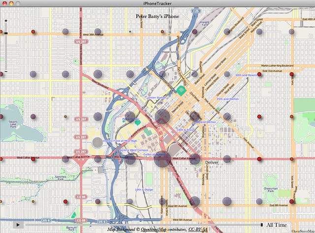
As the author comments:
"In this map of downtown Denver you see the gridding which somewhat obscures the underlying data. However, the largest dot is some way away from my home (which as I think everyone knows is above the famous Wynkoop Brewing Company), and the dots are fairly evenly spread - these certainly do not indicate where I spend most of my time downtown."
2
posted on
04/24/2011 11:09:03 PM PDT
by
Swordmaker
(This tag line is a Microsoft product "insult" free zone.)
To: ~Kim4VRWC's~; 1234; Abundy; Action-America; acoulterfan; AFreeBird; Airwinger; Aliska; altair; ...
Peter Batty, An expert on geospatial location technology weighs in on what he found when he examined the contents of the so-called secret tracking file in his personal iPhone — and it's NOT what the panicky hype and FUD spinners are claiming! Read his report and see his proof! PING!
Please, No Flame Wars, Discuss technical issues, software, and hardware.
Don't attack people!
Don't respond to the Anti-Apple Thread Trolls!
PLEASE IGNORE THEM!!!

Apple iPhone TrackingGate Ping!
If you want on or off the Mac Ping List, Freepmail me.
3
posted on
04/24/2011 11:15:49 PM PDT
by
Swordmaker
(This tag line is a Microsoft product "insult" free zone.)
To: Swordmaker
You or somebody posted another article on that. I've tested two photos, and it nails the location within a block or perhaps two.
Of course not having a phone like that, I don't have that file on my computer, so I can't map the coordinates.
4
posted on
04/24/2011 11:24:41 PM PDT
by
Aliska
To: Swordmaker
Today's follow up:
The scoop: Apple's iPhone is NOT storing your accurate location, and NOT storing history
April 24, 2011
The Summary
So in my previous two posts I discussed how the data I was seeing in my iPhone location logs was actually not very accurate, and certainly didn't reveal where I lived or worked or had stayed on my travels - beyond showing the cities I had been to, including general areas I had visited, as well as some I hadn't. There had been some discussion that the data appeared to be, in a number of cases, the location of cell towers you had been in communication with, although in some cases locations were a long way from where you had been.
The quick summary: I believe I have confirmed that Apple is not storing your location, but the (actual or estimated) location of cell towers (and WiFi access points) that are close to you, to help locate you as you move (these are not necessarily towers that you have been in communication with). In the data I have examined there is nothing that is based on the accurate location of the iPhone. For a good example, see my previous post showing the location of cell equipment in Coors Field baseball stadium, and not revealing the location of my home which is very close to there. In my opinion, if Apple was storing this data in order to know where you had been, they would be storing different, more accurate location data that they have access to.
And, importantly, they are not storing history - the only thing that can be found from the files is when you last visited a general area, not if you made repeat visits. This is especially important as it means that many of the concerns expressed about this data are simply not valid: it cannot be used to determine where you live, or work, or go to school, or who your doctor is.
Here is a report of what Al Franken said:
Sen. Al Franken, a Minnesota Democrat, said it raises “serious privacy concerns,” especially for children using the devices, because “anyone who gains access to this single file could likely determine the location of a user’s home, the businesses he frequents, the doctors he visits, the schools his children attend and the trips he has taken — over the past months or even a year.”
The only part of this that is correct is that the data will show what cities you've visited, with some indication of which parts of a city you may have visited, though nothing definite - there will be records in areas you didn't visit. And it doesn't show repeated visits to the same location, only the last one.
This is an excerpt. Read more at Geothought Blogspot and see more photos and maps demonstrating the hype.
5
posted on
04/24/2011 11:24:45 PM PDT
by
Swordmaker
(This tag line is a Microsoft product "insult" free zone.)
To: Swordmaker
it stores your general location within a margin of error in kilometers
6
posted on
04/24/2011 11:31:25 PM PDT
by
4rcane
To: All
Peter Batty sums his analysis up:
"So to summarize again, there are still some concerns with this data - it does give an approximate indication of places you've been, but not good enough to identify specific buildings or businesses. It doesn't record history - there is no way to tell if you've visited a location multiple times, you can just tell the last time you visited a general area (though there might be clues about multiple visits - for example data showing you visited a neighboring area on a different date, but nothing definitive or detailed about repeat visits). But it definitely doesn't reveal the sort of detailed information that many people have been concerned about. Posted by Peter Batty at 8:51 AM
That's pretty definitive from someone who has exhaustively examined the data and analyzed it who is an expert on geo location. We now have TWO such experts weighing in cutting through the hyperbolic FUD to tell us that this IS NOT sinister, not accurately tracking every iPhone and iPad owner every where they go and sending detailed information back to evil Apple for nefarious purposes.
7
posted on
04/24/2011 11:34:33 PM PDT
by
Swordmaker
(This tag line is a Microsoft product "insult" free zone.)
To: 4rcane; for-q-clinton
it stores your general location within a margin of error in kilometers Fifty meters to kilometers. Yes. Really accurate. Not.
8
posted on
04/24/2011 11:36:37 PM PDT
by
Swordmaker
(This tag line is a Microsoft product "insult" free zone.)
To: All
An interesting comment was made to Peter Batty from a reader and it makes sense! It was observed by Batty that when examining the DB of WIFI hotspots in his iPhone there were FAR TOO MANY in places in his city where he had
never been much less close enough to have been in contact range for his iPhone to have mapped them!
Batty commented that he had never been within the 300 feet WIFI range of many of the mapped spots that showed up in his phone's DB file! The reader said the sheer number of these WIFI hotspots suggested that the location data about these WIFI hotspots had to have been downloaded FROM Apple's centralized database rather than mapped by his iPhone, perhaps in anticipation of need for both GPS mapping purposes and photo ID location tagging reasons, after the iPhone signals the need for data for that vicinity.
That further suggested that much of the cell tower data comes from the same source... And explains why there was spurious cell tower data for areas where Batty could not account for having ever been, miles away, which could have been sent as a response to incomplete or erroneously sent location data.
9
posted on
04/25/2011 12:11:28 AM PDT
by
Swordmaker
(This tag line is a Microsoft product "insult" free zone.)
To: Swordmaker
..don't worry...be happy....the co-ordinates of your front door were taken during the last census.....
0bambi likes using Predator drones....so expect the co-ordinates to be uploaded to eliminate those pesky miscreants that are calling for the LFBC to be released.
10
posted on
04/25/2011 12:41:26 AM PDT
by
spokeshave
(Obamas approval ratings are so low, Kenyans are accusing him of being born in the USA.)
To: Swordmaker
Looking at the plot from my own iPhone, I see a lot of what Batty’s talking about. There are concentrations in areas I haven’t been to. I live east of Atlanta, and rarely venture out to the southwest part of town, but there are abundant markers there.
Also, I recently drove to Orlando, sticking to the Interstate. The map shows points several miles in either direction from the highway in rural areas, probably indicating contact with more distant cell towers in areas where they’re more sparse.
Now, if the WiFi hotspots are indeed being downloaded from Apple, the next questions would be where Apple got that database to begin with, and why. AT&T customers get free access to AT&T hotspots as part of their service, and it’s possible that a future iOS revision will allow the iPhone to automagically connect to those (probably the same for Verizon and overseas carriers, but I don’t know if those are included or how many they have).
To: Swordmaker
13
posted on
04/25/2011 1:10:09 AM PDT
by
GOP Poet
(Obama is an OLYMPIC failure.)
To: 4rcane
it stores your general location within a margin of error in kilometers I worked on this technology for Nortel back in the 90's. Without on board GPS the margin of error depends highly, although not exclusively, on the density and location of the host cells. Another large factor is the type of tower used. Different tower designs move and sway in different ways and that causes a lot of inaccuracy. In urban areas it's generally easier to locate a mobile with a fair degree of accuracy, say a couple of blocks because there is more available receive signal data to use. In rural areas where the cell density is much lower, not so much.
14
posted on
04/25/2011 5:01:55 AM PDT
by
Thermalseeker
(The theft being perpetrated by Congress and the Fed makes Bernie Maddoff look like a pickpocket.)
To: ReignOfError
Now, if the WiFi hotspots are indeed being downloaded from Apple, the next questions would be where Apple got that database to begin with, and why. As to the "where", I'd guess Google. Their mapping project was noted for recording not only location data, but also wireless access points. As for the "why", my best idea is that it has to do with location services (mapping apps, etc.) for fallback/estimation use wen 3G/Edge is unavailable or unreliable.
I.e., if Google (which powers the default mapping app in the iPhone) knows that particular wireless access points exist in certain physical locations, then by triangulating signal strength from any points your device sees (even if it can't connect to the network because it's secured) it can make a decent guess at your location.
15
posted on
04/25/2011 5:05:33 AM PDT
by
kevkrom
("Winning The Future" = WTF = What The F*** / "Kinetic Military Action" = KMA = Kiss My A**)
To: Swordmaker
16
posted on
04/25/2011 7:14:17 AM PDT
by
BunnySlippers
(I love BULL MARKETS . . .)
To: Aliska
I've tested two photos, and it nails the location within a block or perhaps two. That's geotagging, where it tags the photos with your location, so now you can organize your photos by location. It is an option that can be turned off, and the location can be stripped from photos if you want.
To: Swordmaker
How does one check for what data is stored? I tried the download indicated in the original thread the other day - it did nothing but load a map of the world that you could zoom in on to the highway level - but it never loaded any location data....
18
posted on
04/25/2011 9:27:14 PM PDT
by
TheBattman
(They exchanged the truth about God for a lie and worshiped and served the creature...)
To: Swordmaker
Nevermind - the app apparently was updated and it works now. It apparently focuses on highlighting the towers you have pinged off of. I went to Wichita Falls, TX two weeks ago - it shows several little dots in Oklahoma... though we never went to or through Oklahoma.
19
posted on
04/25/2011 9:36:56 PM PDT
by
TheBattman
(They exchanged the truth about God for a lie and worshiped and served the creature...)
Disclaimer:
Opinions posted on Free Republic are those of the individual
posters and do not necessarily represent the opinion of Free Republic or its
management. All materials posted herein are protected by copyright law and the
exemption for fair use of copyrighted works.
FreeRepublic.com is powered by software copyright 2000-2008 John Robinson