Astronomy Picture of the Day
Discover the cosmos! Each day a different image or photograph of our fascinating universe is featured, along with a brief explanation written by a professional astronomer.
2003 September 18 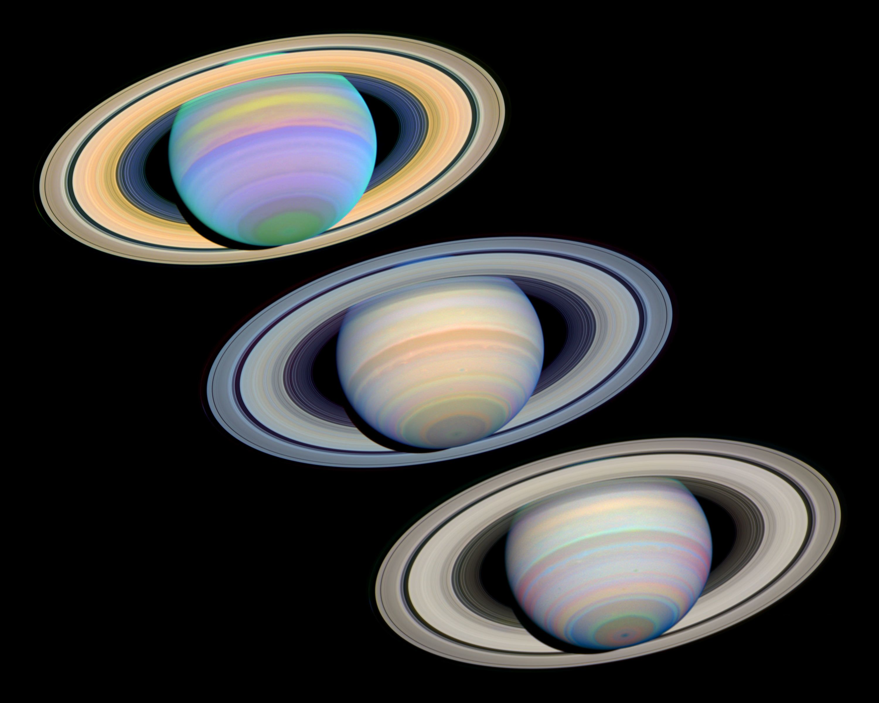
Posted on 09/18/2003 3:33:21 AM PDT by petuniasevan
Discover the cosmos! Each day a different image or photograph of our fascinating universe is featured, along with a brief explanation written by a professional astronomer.
2003 September 18
Explanation: These three views of Saturn were recorded by the Hubble Space Telescope on March 7th of this year, as the southern hemisphere of the solar system's most gorgeous planet reached its maximum 27 degree tilt toward Earth. The images used to construct the false-color pictures were made through a combination of filters covering the electromagnetic spectrum from ultraviolet (top), to visible (middle) and infrared (bottom) wavelengths highlighting different features in the Saturnian atmospheric bands and rings. Well known for its bright ring system and large, mysterious moon Titan, gas giant Saturn is also a planet with a dynamic atmosphere and high-speed winds. In fact, in the 1980s, Voyager spacecraft measured equatorial winds of over 1,000 miles per hour. Giant storm systems, comparable in size to planet Earth itself, have been seen erupting in Saturn's cloud tops.
                                     Saturn      Earth   Ratio (Saturn/Earth)
Mass (1024 kg)                      568.46       5.9736       95.159
Volume (1010 km3)                    82,713    108.321       763.59
Radius (1 bar level) (km)
    Equatorial                       60,268      6,378.1       9.449
    Polar                            54,364      6,356.8       8.552
Volumetric mean radius (km)          58,232      6,371.0       9.140
Ellipticity (Flattening)              0.09796    0.00335      29.24
Mean density (kg/m3)                    687      5,515         0.125
Gravity (eq., 1 bar) (m/s2)          10.44       9.80          1.065
Acceleration (eq., 1 bar) (m/s2)      8.96       9.78          0.916
Escape velocity (km/s)               35.5       11.19          3.172
GM (x 106 km3/s2)                    37.931      0.3986       95.16
Bond albedo                           0.342      0.306         1.12
Visual geometric albedo               0.47       0.367         1.28
Visual magnitude V(1,0)              -8.88      -3.86            -
Solar irradiance (W/m2)              14.90       1,367.6       0.011
Black-body temperature (K)           81.1      254.3           0.319
Moment of inertia (I/MR2)             0.210      0.3308        0.635
J2 (x 10-6)                      16,298.      1082.63         15.054
Number of natural satellites         30          1
Planetary ring system               Yes         No
In case you didn't know, a spacecraft is on its way to Saturn. "Cassini" carries a probe, "Huygens", that is to be dropped onto the surface of Saturn's moon Titan.
Perhaps like this:

Cassini is due to arrive at Saturn 1 July 2004. The probe will be dropped at Titan the next year.
Cassini-Huygens Mission to Saturn and Titan

I will not be updating as I have to go to work. There are live hurricane threads on FR; one of them is http://www.freerepublic.com/focus/f-news/984598/posts
The latest advisory:
WTNT33 KNHC 180839
TCPAT3
BULLETIN
HURRICANE ISABEL ADVISORY NUMBER  49
NWS TPC/NATIONAL HURRICANE CENTER MIAMI FL
5 AM EDT THU SEP 18 2003
...LARGE CATEGORY TWO ISABEL BEARING DOWN ON THE NORTH CAROLINA COAST...
A HURRICANE WARNING REMAINS IN EFFECT FROM CAPE FEAR NORTH CAROLINA TO CHINCOTEAGUE VIRGINIA...INCLUDING PAMLICO AND ALBEMARLE SOUNDS...AND THE CHESAPEAKE BAY SOUTH OF SMITH POINT. A HURRICANE WARNING MEANS THAT HURRICANE CONDITIONS ARE EXPECTED WITHIN THE WARNING AREA...GENERALLY WITHIN 24 HOURS.
ALL PREPARATIONS TO PROTECT LIFE AND PROPERTY SHOULD BE RUSHED TO COMPLETION IN THE HURRICANE WARNING AREA.
AT 5 AM EDT...0900 UTC...THE TROPICAL STORM WARNING IS EXTENDED EASTWARD FROM SANDY HOOK NEW JERSEY TO MORICHES INLET NEW YORK. A TROPICAL STORM WARNING IS NOW IN EFFECT NORTH OF CHINCOTEAGUE TO MORICHES INLET...INCLUDING DELAWARE BAY. A TROPICAL STORM WARNING REMAINS IN EFFECT SOUTH OF CAPE FEAR TO SOUTH SANTEE RIVER SOUTH CAROLINA...FOR THE CHESAPEAKE BAY FROM SMITH POINT NORTHWARD...AND FOR THE TIDAL POTOMAC.
AT 5 AM EDT...0900Z...THE CENTER OF HURRICANE ISABEL WAS LOCATED NEAR LATITUDE 33.1 NORTH...LONGITUDE 74.7 WEST OR ABOUT 155 MILES SOUTH-SOUTHEAST OF CAPE HATTERAS NORTH CAROLINA. THIS IS ALSO ABOUT 145 MILES SOUTHEAST OF CAPE LOOKOUT NORTH CAROLINA.
ISABEL IS MOVING TOWARD THE NORTHWEST NEAR 14 MPH...AND THIS GENERAL MOTION IS EXPECTED TO CONTINUE FOR THE NEXT 24 HOURS. ON THE FORECAST TRACK...THE CENTER OF ISABEL IS EXPECTED TO MAKE LANDFALL IN EASTERN NORTH CAROLINA TODAY. HOWEVER...CONDITIONS ARE DETERIORATING OVER A LARGE AREA WELL BEFORE THE CENTER REACHES THE COAST. HURRICANE CONDITIONS SHOULD BEGIN SPREADING ONTO THE COAST IN THE HURRICANE WARNING AREA LATER THIS MORNING. SUSTAINED HURRICANE-FORCE WINDS COULD ALSO EXTEND INLAND UP TO 150 MILES ALONG THE PATH OF ISABEL.
MAXIMUM SUSTAINED WINDS ARE NEAR 105 MPH...WITH HIGHER GUSTS. THIS MAKES ISABEL A CATEGORY TWO HURRICANE ON THE SAFFIR-SIMPSON HURRICANE SCALE. LITTLE CHANGE IN STRENGTH IS LIKELY PRIOR TO LANDFALL...AND WEAKENING IS EXPECTED AFTER LANDFALL.
HURRICANE FORCE WINDS EXTEND OUTWARD UP TO 115 MILES FROM THE CENTER...AND TROPICAL STORM FORCE WINDS EXTEND OUTWARD UP TO 345 MILES. NOAA BUOY 41002 LOCATED ABOUT 65 MILES SOUTHWEST OF THE CENTER RECENTLY REPORTED SUSTAINED WINDS OF 54 MPH.
ESTIMATED MINIMUM CENTRAL PRESSURE IS 957 MB...28.26 INCHES. NOAA BUOY 41002 RECENTLY REPORTED A PRESSURE OF 978.8 MB...28.90 INCHES.
STORM SURGE FLOODING OF 7 TO 11 FEET ABOVE NORMAL TIDE LEVELS... ALONG WITH EXTREMELY LARGE AND DANGEROUS BATTERING WAVES...IS EXPECTED NEAR AND TO THE NORTH OF WHERE THE CENTER CROSSES THE COAST. STORM SURGE FLOODING OF 4 TO 8 FT ABOVE NORMAL TIDE LEVELS IS EXPECTED IN CHESAPEAKE BAY AND THE TIDAL PORTIONS OF ADJACENT RIVERS.
STORM TOTAL RAINFALLS OF 6 TO 10 INCHES...WITH LOCALLY HIGHER AMOUNTS...ARE LIKELY IN ASSOCIATION WITH ISABEL.
THERE IS A THREAT OF ISOLATED TORNADOES OVER EASTERN NORTH CAROLINA AND SOUTHEASTERN VIRGINIA TODAY
REPEATING THE 5 AM EDT POSITION...33.1 N... 74.7 W. MOVEMENT TOWARD...NORTHWEST NEAR 14 MPH. MAXIMUM SUSTAINED WINDS...105 MPH. MINIMUM CENTRAL PRESSURE... 957 MB.
FOR STORM INFORMATION SPECIFIC TO YOUR AREA...PLEASE MONITOR PRODUCTS ISSUED BY YOUR LOCAL WEATHER OFFICE AND STATEMENTS FROM LOCAL EMERGENCY MANAGEMENT OFFICIALS.
AN INTERMEDIATE ADVISORY WILL BE ISSUED BY THE NATIONAL HURRICANE CENTER AT 8 AM EDT FOLLOWED BY THE NEXT COMPLETE ADVISORY AT 11 AM EDT.
FORECASTER BEVEN


Here is the main APOD pic from a mirror site:

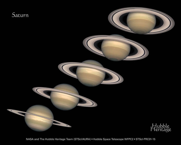
And here is the other pic from an earlier APOD, showing the changing ring tilt over Saturn's orbit:

Disclaimer: Opinions posted on Free Republic are those of the individual posters and do not necessarily represent the opinion of Free Republic or its management. All materials posted herein are protected by copyright law and the exemption for fair use of copyrighted works.