Free Republic
Browse · Search
News/Activism
Topics · Post Article

Skip to comments.

Hurricane Nate
NHC/NOAA ^ | 10/5/2017 | NHC/NOAA

Posted on 10/05/2017 8:49:41 PM PDT by NautiNurse

click here to read article


Navigation: use the links below to view more comments.
first previous 1-20 ... 161-180181-200201-220 ... 321-329 next last
To: All

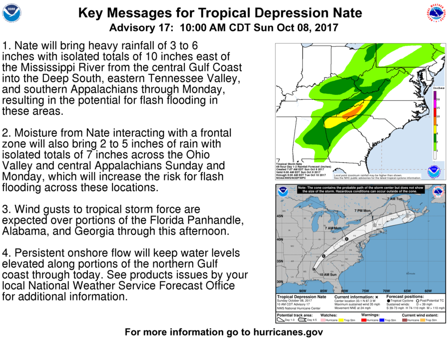
FORECAST POSITIONS AND MAX WINDS

INIT 07/1500Z 26.6N 88.4W 80 KT 90 MPH
12H 08/0000Z 29.1N 89.0W 90 KT 105 MPH
24H 08/1200Z 32.1N 88.3W 60 KT 70 MPH...INLAND
36H 09/0000Z 35.7N 85.5W 35 KT 40 MPH...INLAND
48H 09/1200Z 39.2N 80.6W 30 KT 35 MPH...INLAND
72H 10/1200Z 44.5N 67.5W 25 KT 30 MPH...POST-TROP/EXTRATROP
96H 11/1200Z...DISSIPATED

$$
Forecaster Beven


181 posted on 10/07/2017 8:05:03 AM PDT by NautiNurse (Tear down the Mexican Carrier plant and use the materials to build the wall)
[ Post Reply | Private Reply | To 179 | View Replies]

To: rodguy911

Yep, there is:

10:00 AM CDT Sat Oct 7i
Location: 26.6°N 88.4°W
Moving: NNW at 26 mph
Min pressure: 984 mb
Max sustained: 90 mph

And forecast to get up to 105 mph before landfall - and given intensity is the most difficult part of the forecast, it could even reach low-end Cat 3 - along a section of the Gulf coast that is very prone to surge.


182 posted on 10/07/2017 8:05:30 AM PDT by dirtboy
[ Post Reply | Private Reply | To 178 | View Replies]

To: dirtboy

Great shot!


183 posted on 10/07/2017 8:07:49 AM PDT by Diana in Wisconsin (I don't have 'Hobbies.' I'm developing a robust Post-Apocalyptic skill set!)
[ Post Reply | Private Reply | To 177 | View Replies]

To: All

184 posted on 10/07/2017 8:08:11 AM PDT by NautiNurse (Tear down the Mexican Carrier plant and use the materials to build the wall)
[ Post Reply | Private Reply | To 180 | View Replies]

To: dirtboy

What happened to the Cat.1?Prayers for everyone.


185 posted on 10/07/2017 8:28:25 AM PDT by fatima (Free Hugs Today :))
[ Post Reply | Private Reply | To 182 | View Replies]

To: fatima

Intensity is always the most difficult part of the forecast. Plus, Nate threaded the Yucatan Channel and did not pass over Cuba or the Yucatan, which allowed him to continue intensifying.


186 posted on 10/07/2017 8:52:10 AM PDT by dirtboy
[ Post Reply | Private Reply | To 185 | View Replies]

To: NautiNurse

187 posted on 10/07/2017 8:53:05 AM PDT by dirtboy
[ Post Reply | Private Reply | To 181 | View Replies]

To: NautiNurse

188 posted on 10/07/2017 8:54:26 AM PDT by dirtboy
[ Post Reply | Private Reply | To 181 | View Replies]

To: blam

How far above sea level are you?


189 posted on 10/07/2017 8:55:12 AM PDT by dirtboy
[ Post Reply | Private Reply | To 101 | View Replies]

To: blam

Do you live in Narleens by any chance? For whatever reason, I didn’t see much here about Narleens but it looks like it will be a direct hit.


190 posted on 10/07/2017 9:06:06 AM PDT by Jim W N
[ Post Reply | Private Reply | To 53 | View Replies]

To: NautiNurse
Water vapor image:


191 posted on 10/07/2017 9:07:18 AM PDT by dirtboy
[ Post Reply | Private Reply | To 179 | View Replies]

To: dirtboy

There’s no eye?


192 posted on 10/07/2017 9:08:42 AM PDT by Islander7 (There is no septic system so vile, so filthy, the left won't drink from to further their agenda)
[ Post Reply | Private Reply | To 188 | View Replies]

To: fatima
Prayers have been answered. This storm would be MUCH, MUCH worse if it were not SPEEDING at 23 KNOTS.

Hurricane Harvey pummeled Texas moving at 0 mph and 1 mph for DAYS. That is why Harvey was able to DUMP 50 inches of rain.

H. Nate is over very warm water with NO SHEAR.

H. Nate would be much worse if it LINGERED over the WARM waters of the GULF.

If Harvey moved at 26.5 mph (23 knots equals 26.5 mph about), the people of Houston would have been very grateful.

The downside to Nate is that reduces time to prepare...

I have warned in threads on Nate repeatedly that this storm could intensify quickly because:

1. It was going to travel through the warmest waters of the Carribean.

2. Then go into the Gulf of Mexico.

Another downside of Nate is that the Yucatan was spared allowing Nate to remain intact.

Better for the people of Mexico that this occurred.

Prayers are being answered. I just hope people are grateful for favors from God.

193 posted on 10/07/2017 9:12:13 AM PDT by topher (Traditional values -- especially family values -- which have been proven over time.)
[ Post Reply | Private Reply | To 185 | View Replies]

To: fatima
Another thing to be grateful for: No discernable EYE at this point. A better organized storm (nice eye forming) from what I have seen means it can be more powerful.

Probably true it will not read Cat 3.

Still very potent as a Cat 2...

194 posted on 10/07/2017 9:15:23 AM PDT by topher (Traditional values -- especially family values -- which have been proven over time.)
[ Post Reply | Private Reply | To 185 | View Replies]

In the first threads on this earlier this week, I made sure that Louisiana-Mississippi-Alabama-Florida were on the topics for this system.

These storms are FICKLE. One of the first two threads had Florida Panhandle as the target. The other had New Orleans as the target.

Pensacola, Florida, though may be missed, will get the BAD EASTERN side of this storm.

Always good to be on the WESTERN side.

195 posted on 10/07/2017 9:20:48 AM PDT by topher (Traditional values -- especially family values -- which have been proven over time.)
[ Post Reply | Private Reply | To 194 | View Replies]

Last note;

This storm is supposed to still be a Tropical Storm when it enters Tennessee after traveling through all of Alabama.

Beware of this. Hurricane (TS) Harvey was a TROPICAL STORM through much of the time it was dumping 50 inches of rain on Houston, and then SEVERELY flooding Beaumont/Port Arthur/Orange. It remained a TROPICAL STORM days after it made landfall.

196 posted on 10/07/2017 9:27:42 AM PDT by topher (Traditional values -- especially family values -- which have been proven over time.)
[ Post Reply | Private Reply | To 195 | View Replies]

To: topher
Thanks Topher right now I am down the shore on the East coast about 2 blocks from the ocean.This will not be near us at all but we will get the rain later. Ryan Maue‏ Verified account  @RyanMaue 1h 1 hour ago More Landfall of Hurricane Nate expected > 100 mph winds (Category 2) in next 18-hours. Eye currently forming under strong convection.

Landfall of Hurricane Nate expected > 100 mph winds (Category 2) in next 18-hours. Eye currently forming under strong convection. pic.twitter.com/GxivTpUAwl— Ryan Maue (@RyanMaue) October 7, 2017


197 posted on 10/07/2017 9:30:20 AM PDT by fatima (Free Hugs Today :))
[ Post Reply | Private Reply | To 195 | View Replies]

To: dirtboy; blam
Long Range Radar Loop Mobile AL
198 posted on 10/07/2017 9:33:47 AM PDT by NautiNurse (Tear down the Mexican Carrier plant and use the materials to build the wall)
[ Post Reply | Private Reply | To 191 | View Replies]

To: Islander7

There is a 25 nautical mile wide eye under the cloud cover, according to the Hurricane Hunter recon.


199 posted on 10/07/2017 9:35:43 AM PDT by dirtboy
[ Post Reply | Private Reply | To 192 | View Replies]

To: plain talk

Does anyone know why California, Oregon and washington States don’t get hurricanes. Seems so unfair considering they are on the water as well. Seems like the liberals get away with everything.


200 posted on 10/07/2017 9:39:47 AM PDT by napscoordinator (Trump/Hunter, jr for President/Vice President 2016)
[ Post Reply | Private Reply | To 128 | View Replies]


Navigation: use the links below to view more comments.
first previous 1-20 ... 161-180181-200201-220 ... 321-329 next last

Disclaimer: Opinions posted on Free Republic are those of the individual posters and do not necessarily represent the opinion of Free Republic or its management. All materials posted herein are protected by copyright law and the exemption for fair use of copyrighted works.

Free Republic
Browse · Search
News/Activism
Topics · Post Article

FreeRepublic, LLC, PO BOX 9771, FRESNO, CA 93794
FreeRepublic.com is powered by software copyright 2000-2008 John Robinson