
Mash images for larger or more info! All info updates automatically
Posted on 09/16/2017 5:47:46 PM PDT by NautiNurse
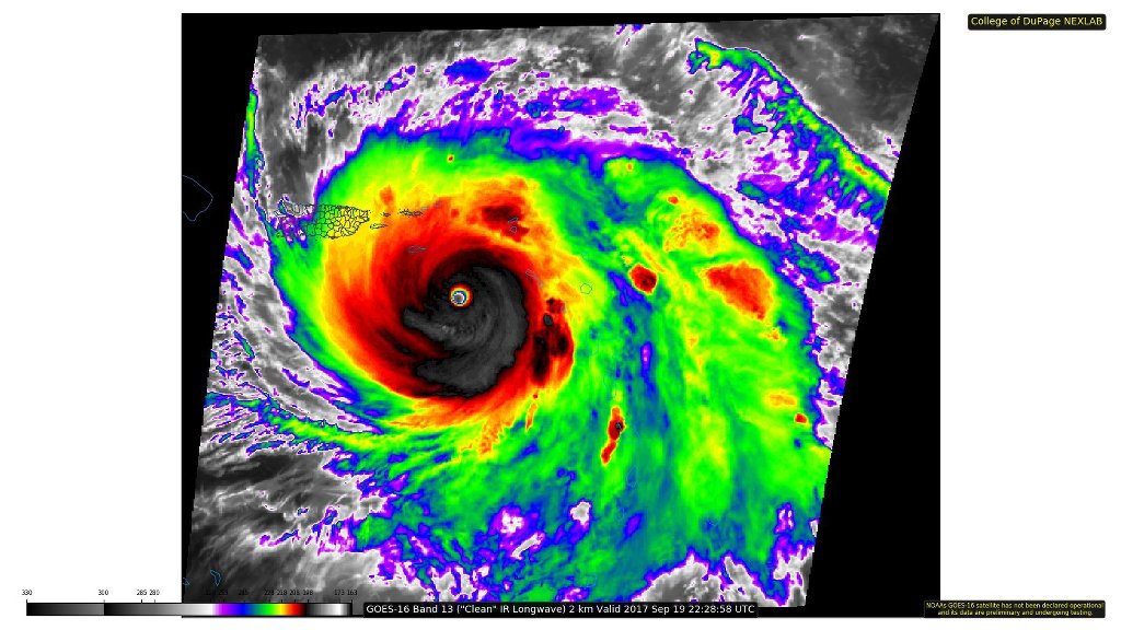
Hurricane Jose has been hanging around, waiting for attention in the wake of Hurricane Irma. Newcomer Maria threatens to impact the Caribbean Islands already devastated by Hurricane Irma, and brushed by Jose. Hurricane Jose threatens to brush or impact New England. Lee appears to be a fish storm at this time.
Mash images for larger or more info! All info updates automatically
| Jose | Maria |
 |
 |
 |
 |
> |
> |
 |
 |
| Public Advisories | Public Advisories |
| Forecast Discussions | Forecast Discussions |
Nothing new under the Sun.

Correction: 7.268.00 MHz
Product: Air Force Vortex Message (URNT12 KNHC)
Transmitted: 19th day of the month at 21:29Z
Agency: United States Air Force
Aircraft: Lockheed WC-130J Hercules with reg. number AF97-5303
Storm Number & Year: 15 in 2017
Storm Name: Maria (flight in the North Atlantic basin)
Mission Number: 5
Observation Number: 17 ( See all messages of this type for this mission. )
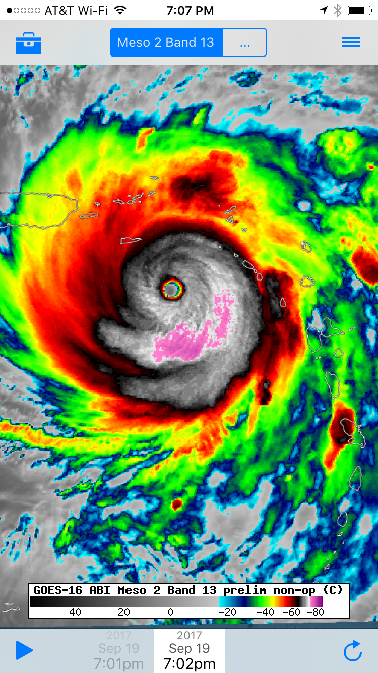
A. Time of Center Fix: 19th day of the month at 21:12:30Z
B. Center Fix Coordinates: 16°46’N 63°58’W (16.7667N 63.9667W)
B. Center Fix Location: 179 statute miles (288 km) to the SE (129°) from San Juan, Puerto Rico (U.S.).
C. Minimum Height at Standard Level: 2,356m (7,730ft) at 700mb
D. Estimated (by SFMR or visually) Maximum Surface Wind Inbound: 137kts (~ 157.7mph)
E. Location of the Estimated Maximum Surface Wind Inbound: 7 nautical miles (8 statute miles) to the NNE (21°) of center fix
F. Maximum Flight Level Wind Inbound: From 102° at 148kts (From the ESE at ~ 170.3mph)
G. Location of Maximum Flight Level Wind Inbound: 7 nautical miles (8 statute miles) to the NNE (21°) of center fix
H. Minimum Sea Level Pressure: 913mb (26.96 inHg)
I. Maximum Flight Level Temp & Pressure Altitude Outside Eye: 13°C (55°F) at a pressure alt. of 3,045m (9,990ft)
J. Maximum Flight Level Temp & Pressure Altitude Inside Eye: 21°C (70°F) at a pressure alt. of 3,040m (9,974ft)
K. Dewpoint Temp (collected at same location as temp inside eye): 12°C (54°F)
K. Sea Surface Temp (collected at same location as temp inside eye): Not Available
L. Eye Character: Closed
M. Eye Shape & Diameter: Circular with a diameter of 10 nautical miles (12 statute miles)
N. Fix Determined By: Penetration, Radar, Wind, Pressure and Temperature
N. Fix Level: 700mb
O. Navigational Fix Accuracy: 0.02 nautical miles
O. Meteorological Accuracy: 0.5 nautical miles
Remarks Section:
Maximum Flight Level Wind: 148kts (~ 170.3mph) which was observed 7 nautical miles to the NNE (21°) from the flight level center at 21:10:30Z
Dropsonde Surface Wind at Center: From 15° at 5kts (From the NNE at 6mph)
XxxxxxX -—— XxxxxxxxX
913mb As noted elsewhere on other forums this is the record low for this year.
Praying for strength and perseverance to you and your family as Maria nears Puerto Rico. Godspeed.
Thank you.
Thanks.
This page is useful — certainly not the last word by any means, but simple enough that most people can grasp the math behind the sheer (not “shear”, for those wondering) forces involved:
http://www.wikihow.com/Calculate-Wind-Load
You are absolutely correct about openings, of course, and if the steel IS in tension, there had better be plenty of it. I am more familiar with tornado damage* - with hurricanes there is of course a much greater materials’ fatigue factor to consider.
*When I was a young man, our entire brick-face home was nearly pulled free from the foundation by what was rated a high end F3 tornado. (I personally think it may have hit low end F4 briefly.) As it was, most of our roof was gone, about 1/2 the walls were down, maybe 1/4 left severely leaning (say, 45 deg.), and another 1/4 were left more upright / vertical, but were “wavy” if sighted along horizontally. Even those last 1/4 of the walls were within generally about 1/2” of the big nails holding the walls to the foundation pulling free. A neighbor had their entire garage (which was separate from the house) lifted up off the concrete pad and dumped more or less intact into a pond in the rear of their property, with no scrape or gouge marks between the pad and the pond. Another (the owner was a quality homebuilder / contractor) had his attached garage sheared off their house and simply obliterated into small pieces. A 3rd had his car lifted up out of his garage (roof gone, walls intact): It somehow landed in the yard with minimal damage. Once debris was cleared, he drove it back into the roofless garage, and into town the following day. Freaking Wizard of Oz stuff I might not believe had I not seen it myself.
Dominica Relief
@dominica_relief
7m
Operator on 2-way “...at least 95% roof damage to buildings that he could see, landslides in every direction, flooding...”
Https://mobile.twitter.com/dominica_relief?p=s
Early reports beginning to come in...sounds bad in Dominica.
Any last minute changes to your shelter plans with Maria’s increased strength?
And it’s still inceasing. 7pm intermediate advisory, wind speed increase, significant pressure drop:
700 PM AST POSITION AND INTENSITY UPDATE... ...EXTREMELY DANGEROUS CATEGORY 5 HURRICANE MARIA STILL STRENGTHENING...
7:00 PM AST Tue Sep 19
Location: 16.9°N 64.1°W
Moving: WNW at 10 mph
Min pressure: 909 mb
Max sustained: 175 mph
pressure down even more last pass 910ish now and they found an estimated 175MPH wind again
1989..Hurricane Hugo , a CAT 4 with 140 MPH winds at the time same exact path....over the Virgin Islands and the eastern tip of PR
On Zello go to Hurricane Maria...they are getting ready. So sad I am having post traumatic stress...
St. Croix is in for it I think.

On/Off Hurricane List Mash Here--> 
Let’s also keep in mind that the current models have a track near a lower 48 brush.
The tracks show this thing going across St. Croix and then a direct hit over Puerto Rico but...
Then it continues toward North Carolina and only turns NE about 50 miles off Cape Hatteras. So east coast, you know how changing models are, but you need to pay attention to planning.
Disclaimer: Opinions posted on Free Republic are those of the individual posters and do not necessarily represent the opinion of Free Republic or its management. All materials posted herein are protected by copyright law and the exemption for fair use of copyrighted works.