
Posted on 08/24/2017 8:44:29 AM PDT by NautiNurse
Potentially catastrophic Hurricane Harvey approaching Texas Gulf Coast.


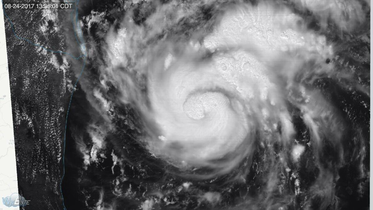
Mash image to find lots of satellite imagery links
Public Advisories
NHC Discussions
NHC Local Hurricane Statements Corpus Christi
NHC Local Hurricane Statements Galveston
Buoy Data near Harvey
We’re planning on hunkering down.....for now.
Hubby on his way home, now.
The eye wall is still somewhat disorganized. People get too impressed with sprawling hurricanes but the really bad ones tighten up with an extremely well-defined eye.
Keep away from windows once this thing gathers there....maybe you have a room with windows you can cover....and remember the generator gives off toxic fumes so vent well...I suspect you know this but thought I’d just say this....
Please be careful....this thing isn’t going to be pretty by any means...
I don’t live down there or have family there but that double bounce hit looks like a very bad mess. I hope all down there take great caution and leave for safer ground.
Hurricane Harvey Discussion Number 18
NWS National Hurricane Center Miami FL AL092017
400 PM CDT Thu Aug 24 2017
Since the issuance of the special advisory at 1800 UTC, data from a
dropsonde released by a NOAA Hurricane Hunter aircraft indicated
that Harvey’s central pressure has dropped to 976 mb. However, the
plane has not measured winds stronger than what was observed by the
previous Air Force flight (although the NOAA P3 is flying a
research mission at a nonstandard level). For now, the initial
intensity will remain 75 kt pending data from another Air Force
flight this evening.
Harvey’s initial motion estimate is 330/9 kt. A strengthening
mid-level high over the eastern Gulf of Mexico is expected to push
Harvey northwestward by tonight, and a northwest or north-northwest
motion should continue up until landfall. However, a stronger
mid-level high centered over the western United States is forecast
to cause Harvey to slow down considerably and stall near or just
inland of the Texas coast by days 3 and 4. After that time, the
track models have trended toward showing Harvey moving slowly
eastward by day 5, but it’s too early to know if the center will
remain over land or re-emerge over the northwestern Gulf of Mexico.
The track guidance is very tightly clustered for the first 36-48
hours, which covers the period of landfall, but then there is much
greater spread in the models after 48 hours when Harvey is forecast
to slow down. Such guidance is usually an indication that the
cyclone will move very little, which is reflected in the official
forecast.
Harvey remains in an environment for further strengthening.
Vertical shear is low, and the hurricane will be moving over a warm
eddy of relatively higher oceanic heat content within the next
12-24 hours. As a result, the NHC intensity forecast calls for
additional intensification at least for the next 24 hours, with
Harvey expected to attain major hurricane strength on Friday.
There may be some fluctuations in intensity up until landfall due to
the possibility of an eyewall replacement or cooling of the shallow
shelf waters of Texas, but regardless Harvey is forecast to reach
the coast as a major hurricane. The intensity forecast after 48
hours is tricky because it all depends on how far inland Harvey
moves into Texas. If it stays stalls closer to the coast, as recent
model trends have suggested, then the cyclone may be able to
maintain a higher intensity with a greater proportion of its
circulation remaining over water. For that reason, the updated NHC
intensity forecast keeps Harvey as a tropical storm on days 3
through 5, but there is greater-than-normal uncertainty in this
part of the forecast.
It is critical that users not focus on the exact forecast track
of Harvey, since cycle-to-cycle adjustment are likely. All
locations within the hurricane and storm surge warning areas should
be preparing for the possibility of major hurricane-force winds and
life-threatening storm surge.
Key Messages:
1. Harvey is expected to be a major hurricane at landfall, bringing
life-threatening storm surge, rainfall, and wind hazards to portions
of the Texas coast. Preparations to protect life and property should
be completed by tonight, as tropical-storm-force winds will first
arrive in the hurricane and storm surge warning areas on Friday.
2. A Storm Surge Warning is in effect for much of the Texas coast.
Life-threatening storm surge flooding could reach heights of 6 to 12
feet above ground level at the coast between the north entrance of
the Padre Island National Seashore and Sargent. For a depiction of
areas at risk, see the Storm Surge Watch/Warning Graphic at
hurricanes.gov.
3. Devastating and life-threatening flooding is expected across the
middle and upper Texas coast from heavy rainfall of 15 to 25 inches,
with isolated amounts as high as 35 inches, from Friday through next
Wednesday. Please refer to products from your local National Weather
Service office and the NOAA Weather Prediction Center for more
information on the flooding hazard.
4. The Potential Storm Surge Flooding Map is available on the NHC
website. This product depicts a reasonable worst-case scenario -
the amount of inundation that has a 10 percent chance of being
exceeded at each individual location. This map best represents
the flooding potential in those locations within the watch and
warning areas.
FORECAST POSITIONS AND MAX WINDS
INIT 24/2100Z 24.7N 93.9W 75 KT 85 MPH
12H 25/0600Z 25.5N 94.8W 95 KT 110 MPH
24H 25/1800Z 26.7N 96.0W 110 KT 125 MPH
36H 26/0600Z 27.8N 96.7W 105 KT 120 MPH
48H 26/1800Z 28.5N 97.1W 85 KT 100 MPH...INLAND
72H 27/1800Z 28.7N 97.2W 45 KT 50 MPH...INLAND
96H 28/1800Z 28.5N 96.5W 35 KT 40 MPH...INLAND
120H 29/1800Z 29.0N 95.0W 35 KT 40 MPH...OVER WATER
If you get strong sustained wind with very heavy rain it’s going to be driven into the house in very unusual places so keep a mop and towels handy. Tape on the windows helps reduce flexing in wind but it’s really there to keep broken glass from flying inward if it actually does break.
I think it’s because this is a slow moving Hurricane which is of the greatest concern though.....more water over long periods trees topple foundations leak and lots of mud damage....

Any hurricane has a lot of rain, but a really slow mover does dump even more rain, and it’ll chew up the beachfront worse too.
Jane..post 226 has some good information on this storm as is anticipated when it comes inland ....you might find interesting to know....
Seems to be the consensus. Storm has no steering mechanism to push it up and out for a time.
I would go west if I were there. Flooding may get quite severe.
Our generator is not a portable type....it’s permanent.
I saw them dumping more dirt and sand on the beaches ....though don’t quite understand how that would do much in a storm surge except maybe slow things down a bit....
Back thread Noa has a first ever tracking on storm surge for this storm that’s interesting to follow....
Right...was reading up on just that today....has been a concern for awhile as they tracked this baby.....would be nice if the waters cooled but that too doesn’t look to happen as they read things currently...

The predicted surge levels actually sound pretty tame to me, only North Padre is getting 10 foot surge. It’ll make a mess and damage structures, sure, but surge won’t be the big story with this one if accurate. Historic, severely damaging storm surge tends to be more in the 18 foot range to my recollection.
I would rule out north or NE as an option.
Maybe book Brownsville.
Find out what time they restock.
WOW... quite a storm!
Disclaimer: Opinions posted on Free Republic are those of the individual posters and do not necessarily represent the opinion of Free Republic or its management. All materials posted herein are protected by copyright law and the exemption for fair use of copyrighted works.
