Posted on 02/12/2017 4:26:47 PM PST by janetjanet998
Edited on 02/12/2017 9:33:58 PM PST by Admin Moderator. [history]
The Oroville Dam is the highest in the nation.
Is this just the beginning? I’m less concerned about this than about those dams that will be forced to release into overfull downstream reservoirs, rivers and levees when the heat of summer strikes.
The work you put in to this project with hopes of some brave soul sticking his neck out to tell the truth—won't be enough to overcome the faux-American, lockstep bureaucrats who run the dams. 60 years ago this type of non-serious mind in charge would be unthinkable! Now it's the norm. But thank you for this valiant effort which is spellbinding to a non-scientist who didn't know how dams are made and maintained. It's a beautiful application of engineering.
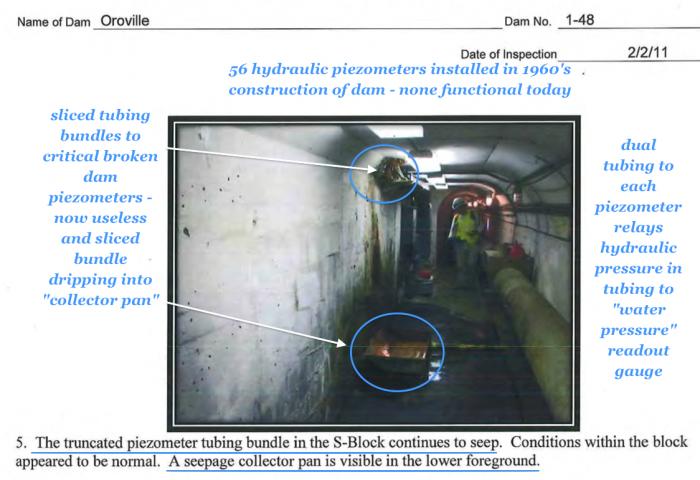
I’m not sure if this has been seen and cited, but this is a “fourth” document that seems to have since been redacted, or otherwise made ‘hard to find’...
I think that ER333 has already cited it, but it’s maybe nice to have for future reference.
main spillway to be turned back on WED,lake will be around 850 ft by then.....I assume after 5-6 days it will fall back to 835 feet and the spillway will be shutoff for the summer which will be around MAY 16th
of course they could run it below 835 at lower flows and drop below 835ish this time also
Good tidings EarthResearcher333. Thanks for your many thoughtful and well documented posts.
In regard to my post 3574, you ask:
“Why are you making these inferred assumptions? (thousands driving over & no one registered much concern about it at the time) & (This (apparently wasn’t an issue at the time)?”
Admittedly, these are just assumptions. However, I’d classify them as more “informed” assumptions than “inferred” assumptions. Either descriptor applies.
I’ve done a lot of boating in California and have been on many lakes, although I avoided Oroville, partly because I’ve always heard it was too crowded. The day use boat ramp north of the dam is 13 lanes wide with hundreds of parking spaces. If they had just 20 boat launches a day during this 3 month period in 2011 when the lake was higher than its ever been, at 2 people per boat, that translates to “thousands” of potential dam observers. I don’t have the actual traffic counts though.
Northern California is generally green in February, drys out by May, and is universally brown by August. A wet or green spot would definitely stand out in August, but not so much in February or May. I have never known fellow boaters to take notice of a green area on any dam in August, or heard of it on social media. It is my assumption that they would have taken notice of this, and records of this would have come out by now. But that is a rather speculative assumption.
If the “green spot” water is originating from the reservoir, then the flow rate into it must be a function of the reservoir level. As Ray76 pointed out, this is key to assessing where this water originates.
The DSOD report from 2/2/11 you cited says “the area ranged from damp to wet”. On that date, the lake level was about 826’ according to DWR. The lake level didn’t get down that low again until January the following year, so the same flow rate or more should have been sustained across this period.
The DSOD report from 5/18/11 you cite says “the ground remains wet” with “lush grass and weeds”. At this time, the reservoir was about 887’, 60’ higher than the February report. The green spot would have had quite a bit more head on it, but significantly greater flow was not apparently observed.
Now if we had a report from August through October 2011, that still said this area remained wet and green, then it would be reasonable to conclude the only plausible source of water would be the lake.
Another key thing to assess is how the vertical channels below the wet spot got formed.
At some point in time, this wet spot must have been flowing sufficiently to generate these multiple erosion channels, many of which (I’m assuming) would be flowing concurrently rather than sequentially. It takes a lot of flow to push a steep cobble embankment aside rather than perk back into it. That peak flow event must have been at peak lake level, if the water originated from the lake. The longest sustained peak lake level (+890’) was the summer of 2011, when (I’m assuming) no one noticed these channels being formed.
Now it could be a plausible assumption that this peak wet spot flow, associated with peak lake level, might have evaporated away when perking out on to the hot SouthWest face of the dam in the summer. However, even in the summer, it can get kind of chilly at night. I find it hard to believe that a flow rate sufficient to erode multiple channels down the face of a cobble embankment would just evaporate away through the night every night for months on end. That doesn’t seem plausible to me, but I could be wrong.
If those erosion channels were initiated by high lake levels, then why would they stop eroding as long as the lake was high? Once there is sufficient pressure and flow to push the surface materials aside, wouldn’t that process cascade until the dam collapsed? Unless that flow originated from a much more limited source, like a rain fed groundwater channel.
Upthread, a thousand or so post ago, I thought it seemed plausible that the wet spot water was originating from the reservoir. However, upon reasoning this out, it now seems more reasonable to me that this water originates from some underground channel or other rain induced source. Obviously, no one, including DWR knows what that source is at this time. It is an issue that should be investigated, and then mitigated. But I think the imminent threat of a Teton Dam style failure seems minimal, at least until the next rainy season. I’m downstream of the dam, so I do care about these things.
As noted in an early upthread posting, the channels have been somewhat of a mystery, including to DWR. The 2011 DSOD report is the first notation on their revealing it in writings.
(1) The 2011 DSOD report validates with direct information from on the ground personal observations of the presence of saturation at the "lush greening" area yet no surface waterflow in the channels. I had come to this conclusion in a different analysis. Now I have confirmation of this via direct reports.
jpal: "At some point in time, this wet spot must have been flowing sufficiently to generate these multiple erosion channels, many of which (I’m assuming) would be flowing concurrently rather than sequentially."
(2) The channels have a unique formation process. Just as DWR/DSOD discovered in a "piece" of this (their first step or "a" first step).
(3) DSOD's inspection report data (Feb & May 2011) confirms in two data points within these 4 months, there was greening & dampness in the wet area, and no greening, waterflow, or dampness below (in the channels).
(4) with (1)(2)(3) the channels become an important contrasting evidential clue to what this total effect "is" verses what "it's not".
Keep going...
Like the game of "Clue": DWR has been trying to understand the mystery of the Green Wet Area and the "Erosion Channels" formed directly below the Wet Area. Using a "fingerprint" type of analysis of exact matching small erosion channel locations from 2011 and 2015, it reveals clues (to the question of: what it "is" and what "it's not"). DSOD inspectors have noted that when the Wet Area is saturated there is no waterflow observed in the downslope erosion channels. So how have these erosion channels formed?
These special forensic side-by-side images are high resolution zoom of exact matching channel locations. The images on the left are 2011 and the right are 2015. The light colored whitish to light green dots are the Zone 3 fill of the largest rock near the dam slope surface. The Zone 3 fill Shell is noted as sands, gravels, cobbles, and boulders to 24" max (including minus of 25% in gravels). The dark areas of the image are the finer materials. The light dots and brighter areas are the larger to largest materials. Marker dots in the images reveal that the larger material is not moving, rather it more of it is being exposed over time. The zoom with non-processing (for larger rock contrasting) shows that the channels are slowly widening and slowly exposing more of the larger to largest materials. These images reveal the depth increase by the increase in exposed larger rock. Clearly there is a process that is occurring. Yet DSOD inspectors could not see water flowing in the channels when the Green Wet area was saturated.
These erosion channels are unique to the lower section of the Green Wet Area. Heavy rains, if the cause, would form channels elsewhere including above the green wet area, yet there are none (dense channels). If the "water source" to the green area were proposed to somehow transition to high flow and then somehow transition back to wet and damp with no downhill flow… theoretically this may cause erosion channels. But the strong on/off part doesn't exactly follow a typical "water source" mechanism. What one piece is: Clearly there is a removal process of the lighter materials leaving the larger rock to result in "channels". (The clue to the next part of this mystery is hidden in other particular surface section on the dam). Due to the long term side-by-side forensic imaging & the DSOD "active" moment examination, "what it's not" is it is not a on/off of sudden water flow from the Green Wet Area.

The next “clue”... What keeps the Zone 3 material “together”?
Occam’s razor indicates that these erosion channels (and by inference, the “green spot”) are not formed by reservoir water because the channels are not flowing when the reservoir head is the highest. The simplest explanation would be a rainwater fed “seepage channel”, just as the dam builders had noted during construction. If this is a deep channel with a small catchment basin, analogous to the sink hole that almost opened up under the emergency spillway, then it might normally generate low flow seepage to keep the green area wet in the winter and spring. But during intense rain, it could gather enough water to generate the visible erosion.
It would be useful to include an assessment of current 2017 photos in this green spot erosion assessment. Did the erosion channel rock pattern change this year? If not, that wound’t necessarily be conclusive.
This year had the greatest aggregate precipitation, but not necessarily the most intense. The most intense precipitation in the Sierras is during short duration thunderstorms. It is plausible the (hypothesized) catchment basin only fills during intense thunder showers, which then flows down and into the dam with enough head to erode the surface channels as the flow perks out. This could explain why the (hypothesized hilltop) catchment basin is small enough to be unnoticed, and why no one (apparently) has seen these dam erosion channels being formed, because the rain was so intense that they were seeking shelter.
All speculation? No doubt. That’s largely what this forum is all about.
A Q&D diagnostic that could be done would be to place various size and colors of stones in the erosion channels that would move or get washed away at different flow rates. That way it would be relatively easy to do a remote assessment of if and when the erosion channels have been reactivated. My speculative hypothesis is this it would be after thundershowers.
In any case, if there are existing piping channels through the dam that can sustain enough flow to erode its surface, and those channels ever merge with the reservoir water, then this could quickly develop into an uncontrollable situation. We all need to put and keep the pressure on DWR to resolve this issue before it resolves itself.
DSOD documents reveal that there is a "slope stability" issue worthy of noting in their 2015 inspection report regarding the "Green Wet Area". The context of their "slope stability" notation is in reference to the Green Wet spot. For beneath the Green Wet spot is a dense series of mysterious "erosion channels" that DSOD has investigated in 2011 (documented in their inspection report) of noting that they didn't see any waterflow in the erosion channel but the Greening area was "wet and damp". They too thought that there might be a clue to water flowing in the channels when the wet area was saturated. After all, something has to be forming these channels…

I stay way from his razor... seen too many people get cuts over the years....
To a layman like me, my starting point assumption was that the erosion channels under the green spot HAD to have been caused by flowing water on the surface. This would be very serious whether it came from a natural spring from the hillside flowing into the dam, or from a leak inside the dam.
A major problem with my thinking was that no one has ever seen flowing water on the surface through these numerous channels. The overall volume of water would have to be large to even show on the surface. If water HAD shown as a surface flow it would have been cause for an immediate loud alarm, and it certainly would have been documented. There is no record of that ever happening.
Apparently there is an alternative explanation that involves water seepage taking out some of the material, but leaving other (generally larger) material behind. That is what EarthResearcher333 has been researching, and provided evidence for on this thread. In spite of my common sense saying otherwise, he has convinced me.
A side issue I have not seen addressed is the SIZE of these channels. They are obvious in photographs, but I have never seen a picture with a person or other object that would put them in perspective. Given the size of the dam, my guess is that they are each a few feet wide, with an unknown depth (shallow relative to their width).
Another side issue I have not seen mentioned is the number of these channels, and the fact that they seem somewhat evenly spaced and approximately the same size. This is not what I would expect from a single point source. Likewise, as time went by, I would have expected a small number of channels to become dominant, with a noticeable difference between them.
My layman’s conclusion on this is that the source is relatively evenly spread out over the length of the green spot. This would be consistent with seepage along a construction related seam in the impermeable wall inside the dam, but NOT consistent with a natural spring along the side of the dam.
So... My personal conclusion is that common sense failed me - the channels were not caused by water flowing on the surface. It also seems unlikely that the water is from a point source.
If the water is from seepage along a construction related seam inside the dam, another question is how much head of water is needed to cause seepage to begin, and how long a lag exists between the seepage starting up and the water finding its way to the surface.
Regardless, the most important question is not the source of the water or whether it has ever flowed on the surface. The CRITICAL question is whether it is getting worse.
Looks like they're starting to recognize it after having their nose rubbed in it.
I look at it this way:
We have a “wet area.” An upper strata of that wet area had organics to the extent that grass grew. A lower strata did not. The lower strata, like the upper strata was still within a zone we are calling a wet area.
The lower strata, when saturated, would sometimes be also exposed to rain. The rain would repeatedly carry off the “fines”, such a fine sands and smaller grained non-organics. As it did so, the larger gravels were striated into rivulets due to the action of the small grains being carried by water pushing the larger cobbles into stripes.
Another general observation:
DWR seems to have arranged an unintentional experiment for us dam watchers to observe. Apparently they plan to open the spillway when the lake level reaches 850 feet in the next few days, and then leave the spillway closed once they have again lowered the lake.
Since the snowpack is at a record level, it seems likely that we will have much higher than normal runoff. DWR apparently “thinks” the reservoir will have enough capacity to hold this much water without using the spillway.
If the DWR is right then this approach will give them more time to work.
The “experiment” comes from the lake level once again rising to a level near its full capacity. If the head of water has an impact on seepage in the green spot we will most likely see it sometime in the next few months.
I very much hope DWR will have a credible means to actively monitor and study the green spot during this period. If they believe their own propaganda (”its just rain”), then they may not.
We have a “wet area,” [the Christy Jones Memorial Lawn and Undermined Area] An upper strata of that wet area had organics to the extent that grass grew. A lower strata did not. The lower strata, like the upper strata was still within a zone we are calling a wet area.
There...fixed it.
LOL!
Disclaimer: Opinions posted on Free Republic are those of the individual posters and do not necessarily represent the opinion of Free Republic or its management. All materials posted herein are protected by copyright law and the exemption for fair use of copyrighted works.