Posted on 10/24/2023 7:57:41 PM PDT by janetjanet998
NWS National Hurricane Center Miami FL EP182023 1000 PM CDT Tue Oct 24 2023
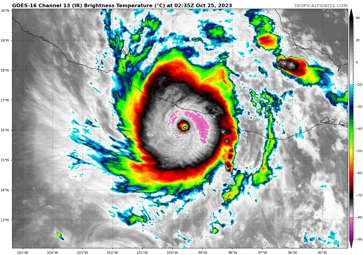
A nightmare scenario is unfolding for southern Mexico this evening with rapidly intensifying Otis approaching the coastline. Satellite images show that Otis has continued to intensify, with Dvorak Data-T estimates between 130-145 kt during the past few hours. The initial wind speed is set to 140 kt as a blend of these values, making Otis a Category 5 hurricane. Otis has explosively intensified 95 kt during the past 24 hours, a mark only exceeded in modern times by Patricia in 2015.
Otis should maintain category 5 status before the hurricane makes landfall near the area overnight or early on Wednesday. The only significant change to mention to the track forecast is that it has been shifted to the right due to a recent wobble to the east and the latest model trends, and a general north-northwest motion at about 8 kt is anticipated through landfall. Rapid weakening is anticipated after landfall, and Otis should dissipate tomorrow night over the higher terrain of Mexico.
This is an extremely serious situation for the Acapulco metropolitan area with the core of the destructive hurricane likely to come near or over that large city early on Wednesday. There are no hurricanes on record even close to this intensity for this part of Mexico.
No computer model last night at this time even had it a hurricane let alone a CAT 5
People will be caught Off guard
Only good news
It’s a small storm and the worst side (right) may go just south of the core of the city
But otherwise ouch
Please believe me, the folks in the USA are more informed, worried and aware, people in Mexico see this as small potatoes and won’t be ready.
Yikes! Tourists better get the hell out. Expect landslides.
Otis will become the first Eastern Pacific hurricane ever recorded to make landfall as a Category 5 in Mexico.
Sounds naughty!
Prayers up, for all in Otis’ path.
Yikes! Tourists better get the hell out. Expect landslides.
___
Too late storm hitting now
Eye should make landfall in a few hours
Again last night it was only supposed to be a tropical storm and go north of the city
TCPEP3
BULLETIN
Hurricane Otis Advisory Number 12
NWS National Hurricane Center Miami FL EP182023
1000 PM CDT Tue Oct 24 2023
...OTIS RAPIDLY INTENSIFIES TO A CATEGORY 5 HURRICANE...
...CATASTROPHIC DAMAGE LIKELY WHERE THE CORE OF THE HURRICANE MOVES
ONSHORE...
SUMMARY OF 1000 PM CDT...0300 UTC...INFORMATION
I wonder if the Cliff Divers are still jumping?
In a shocking turn of events, Hurricane #Otis in the Eastern Pacific has unexpectedly, explosively intensified from a tropical storm to a Category 4 hurricane in just 12 hours.
Even worse, the storm is expected to make a catastrophic landfall tonight as a Category 5 hurricane… pic.twitter.com/VNOhGzNPOy— Colin McCarthy (@US_Stormwatch) October 25, 2023
Hurricanes go the wrong way on the pacific. sizzle away.
https://search.usa.gov/search?v%3Aproject=firstgov&query=Hurricane+Otis&affiliate=nws.noaa.gov
Hurricane Otis Forecast Discussion - National Hurricane Center
www.nhc.noaa.gov/text/refresh/MIATCDEP3+shtml/242356.shtml
Hurricane Otis Forecast Discussion. 018 WTPZ43 KNHC 242356 TCDEP3 Hurricane Otis Special Discussion Number 11 NWS National Hurricane Center Miami FL ...
Hurricane Otis Forecast Advisory - National Hurricane Center
www.nhc.noaa.gov/text/refresh/MIATCMEP3+shtml/242055.shtml
hurricane otis forecast advisory. ... hurricane center
located near 15.3n 99.5w at 24/2100z position accurate within 20 nm present movement toward the ...
HURRICANE OTIS
www.nhc.noaa.gov/refresh/graphics_ep3+shtml/205759.shtml?swath
About this product: This graphic shows how the size of the storm has changed, and the areas potentially affected so far by sustained winds of tropical ...
Hurricane Otis Forecast Discussion - National Hurricane Center
www.nhc.noaa.gov/text/refresh/MIATCDEP3+shtml/221448.shtml
On this track, the center of the hurricane will make landfall within the hurricane warning area late tonight or early Wednesday. Key Messages: 1. Otis ...
HURRICANE OTIS
www.nhc.noaa.gov/refresh/graphics_ep3+shtml/235640.shtml?mltoa34
* If the storm is forecast to dissipate within 3 days, the “Full Forecast” and “3 day” graphic will be identical.
They missed a hurricane the next day,
yet they can accurately forecast temps in tenths of degrees decades later.
Uh huh sure.
I usually watch these things and heard nothing
O boy! Well it will be an experience…
A vlogger NWW116 (Andrew Heisham) on YouTube is covering live - good webcams
Lots of rickety shacks in Acapulco. And I’d be surprised if there are many tourists there due to the crime.
Too bad...we used to have fun there.
Disclaimer: Opinions posted on Free Republic are those of the individual posters and do not necessarily represent the opinion of Free Republic or its management. All materials posted herein are protected by copyright law and the exemption for fair use of copyrighted works.