Posted on 11/02/2019 8:08:49 AM PDT by null and void
By 3 minute Read
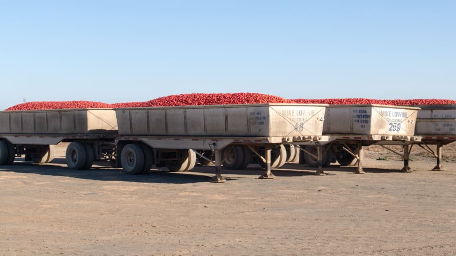
Most of our food is moved across great distances—and through many different forms of transit—before it reaches our plates.
My team at the University of Illinois just developed the first high-resolution map of the U.S. food supply chain.
Our map is a comprehensive snapshot of all food flows between counties in the U.S.—grains, fruits and vegetables, animal feed, and processed food items.
To build the map, we brought together information from eight databases, including the Freight Analysis Framework from Oak Ridge National Laboratory, which tracks where items are shipped around the country, and Port Trade data from the U.S. Census Bureau, which shows the international ports through which goods are traded.
We also released this information in a publicly available database. 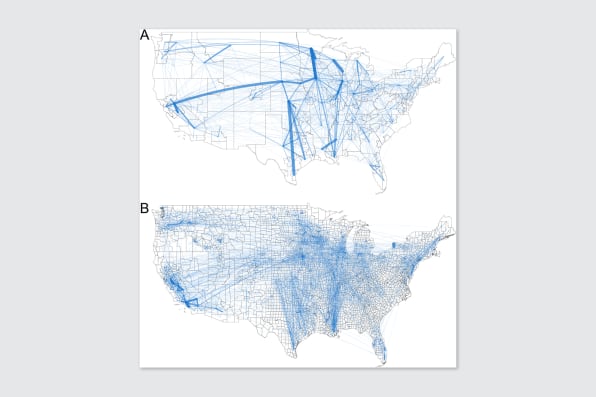
This map shows how food flows between counties in the U.S. Each line represents the transportation of all food commodities, along transit routes, such as roads or railways. [Image: Environmental Research Letters (2019)]
What does this map reveal?
1. Where your food comes from
Now, residents in each county can see how they are connected to all other counties in the country via food transfers. Overall, there are 9.5 million links between counties on our map.
All Americans, from urban to rural are connected through the food system. Consumers all rely on distant producers, agricultural processing plants, food storage like grain silos and grocery stores, and food transportation systems.
For example, the map shows how a shipment of corn starts at a farm in Illinois, travels to a grain elevator in Iowa before heading to a feedlot in Kansas, and then travels in animal products being sent to grocery stores in Chicago.
2. Where the food hubs are
At over 17 million tons of food, Los Angeles County received more food than any other county in 2012, our study year. It shipped out even more: 22 million tons.
California’s Fresno County and Stanislaus County are the next largest, respectively. In fact, many of the counties that shipped and received the most food were located in California. This is due to the several large urban centers, such as Los Angeles and San Francisco, as well as the productive Central Valley in California.
We also looked for the core counties—the places that are most central to the overall structure of the food supply network. A disruption to any of these counties may have ripple effects for the food supply chain of the entire country.
We did this by looking for counties with the largest number of connections to others, as well as those that score highly in a factor called “betweenness centrality,” a measurement of the places with the largest fraction of the shortest paths.
San Bernardino County led the list, followed again by a number of other California transit hubs. Also on the list are Maricopa County, Arizona; Shelby County, Tennessee; and Harris County, Texas.
However, our estimates are for 2012, an extreme drought year in the Cornbelt. So, in another year, the network may look different. It’s possible that counties within the Cornbelt would show up as more critical in non-drought years. This is something that we hope to dig into in future work.
3. How food travels from place to place
We also looked at how much food is transported between one county and another.
Many of the largest food transport links were within California. This indicates that there is a lot of internal food movement within the state.
One of the largest links is from Niagara County to Erie County in New York. That’s due to the flow of food through an important international overland port with Canada.
Some of the other largest links were inside the counties themselves. This is because of moving food items around for manufacturing within a county—for example, milk gets off a truck at a large depot and is then shipped to a yogurt facility, then the yogurt is moved to a grocery distribution warehouse, all within the same county.
The food supply chain relies on a complex web of interconnected infrastructure. For example, a lot of grain produced throughout the Midwest is transported to the Port of New Orleans for export. This primarily occurs via the waterways of the Ohio and Mississippi Rivers.
The infrastructure along these waterways—such as locks 52 and 53—are critical, but have not been overhauled since their construction in 1929. They represent a serious bottleneck, slowing down innumerable supply chains nationwide, including that of grain. If they were to fail entirely, then commodity transport and supply chains would be completely disrupted.
Railroads are also important for moving grain. Fresh produce, on the other hand, is often moved around the country by refrigerated truck. This is due to the need to keep fresh fruits and vegetables—relatively high value agricultural products—cool until they reach the consumer. In future work, we hope to evaluate the specific infrastructure that is critical to the U.S. food supply chain.
Megan Konar is assistant professor of civil and environmental engineering at University of Illinois at Urbana-Champaign. This post originally appeared on The Conversation.
Yeah, I went to the site and still couldn’t see the maps. I wanted to see if they were honest about my county. We get the garbage other grocers refuse. One week, chips might fill up a whole aisle. The next week, we’ll be without dairy. Welcome to VenezuTexas.
The red spot in TX is the Houston shipyard where we get imports from other countries.
+1
No, I thought you were clueless about agriculture in LA County since you seemed to express surprise that LA County could possibly ship more agricultural goods that it brings in. It was the top agricultural county in the country until the 1950s. It still has lots of farmland. At almost 5,000 sq miles the county is more than just the homeless downtown.
http://file.lacounty.gov/SDSInter/acwm/232575_CROPREPORTYEAR2014FINAL.pdf
I don’t believe in classifying endless stuff, but I would have this study classified.... Too detailed and easy for an enemy to use.
Except read this forum I suppose.
New Jersey. The garden state
the second largest food exporter in the world is holland.
How does that happen. Holland has a tiny fraction of the land in the USA.
The reason for this is that holland is the wall to wall with green houses these days. green houses produce 10 times the food that an open air one season acre of land produces.
There is another reason.
Amsterdam is the port through which the food from spain’s altimera region comes. Altimera is the place where sergi leone shot his spaghetti westerns. its a desert. but they have placed so many greenhouses there that they can be seen from space. unlike the high tech greenhouses of holland —these are mostly low tech. But there are so many of them that they produce about half of the vegetables that europe consumes. those vegetables enter through hollands main port at amsterdam.
Thus amerstdam is the second greatest food exporter in the world.
likely its food reexporting that makes LA a major exporter. the source of their food is likely mexico, the rest of latin america and asia.
If you think people could grow their own food in just the time they now use to play video games?
Not a chance, they would starve.
There is a reason over 70% of our population used to be in the food production business.
There is a reason New Jersey is called the Garden State. It’s far from entirely being refineries, slums, and suburban sprawl. With California in the grip of a leftist state government and arguably suffering the wrath of God, the need for other states to develop fruit and vegetable production is incumbent. Not to sound like a liberal, but suburban growth has taken away farmland near the major cities. Why can’t, say, northern Missouri, within a day’s drive of the Great Lakes cities and the Texas Triangle, develop a more active orchard, vineyard, and vegetable agriculture?
Fair enough!
#48 Cool!
Here are some photos.
https://imgur.com/gallery/3ONen
Since the beginning of time, people have grown their own food on their own land and didn’t starve.
And nowadays some yutes play video games hours on end, 365 days a year...plenty of time to grow a garden.
Disclaimer: Opinions posted on Free Republic are those of the individual posters and do not necessarily represent the opinion of Free Republic or its management. All materials posted herein are protected by copyright law and the exemption for fair use of copyrighted works.