Skip to comments.
Images suggest N.Korea building ballistic subs
NHK - TV Japanese national TV network ^
| NHK - TV Japanese national TV network
Posted on 09/19/2019 10:14:20 PM PDT by AmericanInTokyo
US researchers say satellite images suggest North Korea may be preparing to deploy a ballistic missile-capable submarine.
Researchers at the Middlebury Institute of International Studies and satellite operator Planet Labs have told NHK that they have analyzed images of a shipyard in the eastern port city of Sinpo.
On September 3 at least 13 pillar-like objects could be seen along a quay, with some vehicles moving around.
Images taken on September 12 show the construction of a large structure straddling the quay and the water.
The most recent images from Thursday, show the structure covering almost the entire quay.
The researchers say the structure is now about 100 meters long, which is much longer than what is used to build North Korea's conventional submarines.
They say Pyongyang may be preparing to launch a new submarine capable of carrying ballistic missiles.
Senior Research Associate David Schmerler says the structure could be used for the maintenance and development of submarines, and drive the country's submarine-launched ballistic missile program.
TOPICS: Foreign Affairs; Front Page News; Government; News/Current Events
KEYWORDS: communists; kimjongun; nkorea; northkorea; sinpo; slbm; untrustworthy
Navigation: use the links below to view more comments.
first previous 1-20, 21-30 last
To: AmericanInTokyo
21
posted on
09/20/2019 7:14:50 AM PDT
by
wastedyears
(The left would kill every single one of us and our families if they knew they could get away with it)
To: KC_Lion
22
posted on
09/20/2019 12:04:52 PM PDT
by
Army Air Corps
(Four Fried Chickens and a Coke)
To: TXnMA
I've read reports that the vertical launch tube is in the aft end of the sail, but that doesn't sound too practical to me...
The Soviet Navy's Golf class subs were configured that way.
23
posted on
09/20/2019 12:15:09 PM PDT
by
Army Air Corps
(Four Fried Chickens and a Coke)
To: 2ndDivisionVet
Agreed. I’d also suspect that all they’re doing is just assembling something that was provided to them by China, Russia, Germany, or maybe even the Netherlands.
24
posted on
09/20/2019 1:42:12 PM PDT
by
MeganC
(There is nothing feminine about feminism.)
To: AmericanInTokyo
It would be a logical next step.
25
posted on
09/21/2019 4:13:22 PM PDT
by
Crucial
To: AmericanInTokyo; free_life; Widget Jr; Army Air Corps; TigerLikesRooster
I hadn't planned on going to this trouble, but as a counterpoise to
free_life's "contribution", here's some solid intel re Nork submarines and their bases at
Sinpo:

As I mentioned earlier, at coordinates
Latitude: 40.025417°
Longitude: 40.025417°
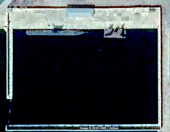
DPRK's lone "Gorae"-class SSB is docked in its own pen at Sinpo:
~~~~~~~~~~~
The main Nork submarine base is on the island immediately offshore from Sinpo city.
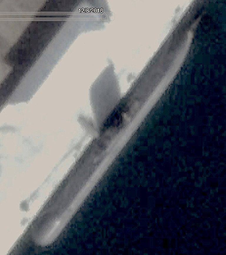
The colors in the graphic above are wrong. Operational Romeos (at top in poster, above) are equipped with a dark gray anechoic coating. Romeo refits -- including adding the anechoic coating -- are done in the drydock on the island, at
Lat: 39.997814°
Lon: 128.200215°
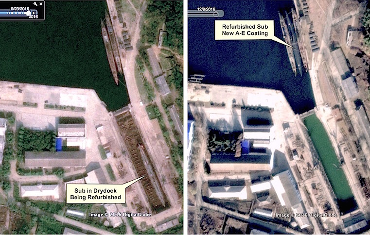
At left, a
Romeo is in the drydock, being refurbished,, while two more are moored, awaiting refit. At right, the drydock is flooded, and the refurbished
Romeo, with its new
dark gray anechoic coating, is moored between two other
Romeos. (Note the three mini-subs now moored at middle left...)
To the northwest of the drydock, there is a large cove, with several submarine mooring sites.
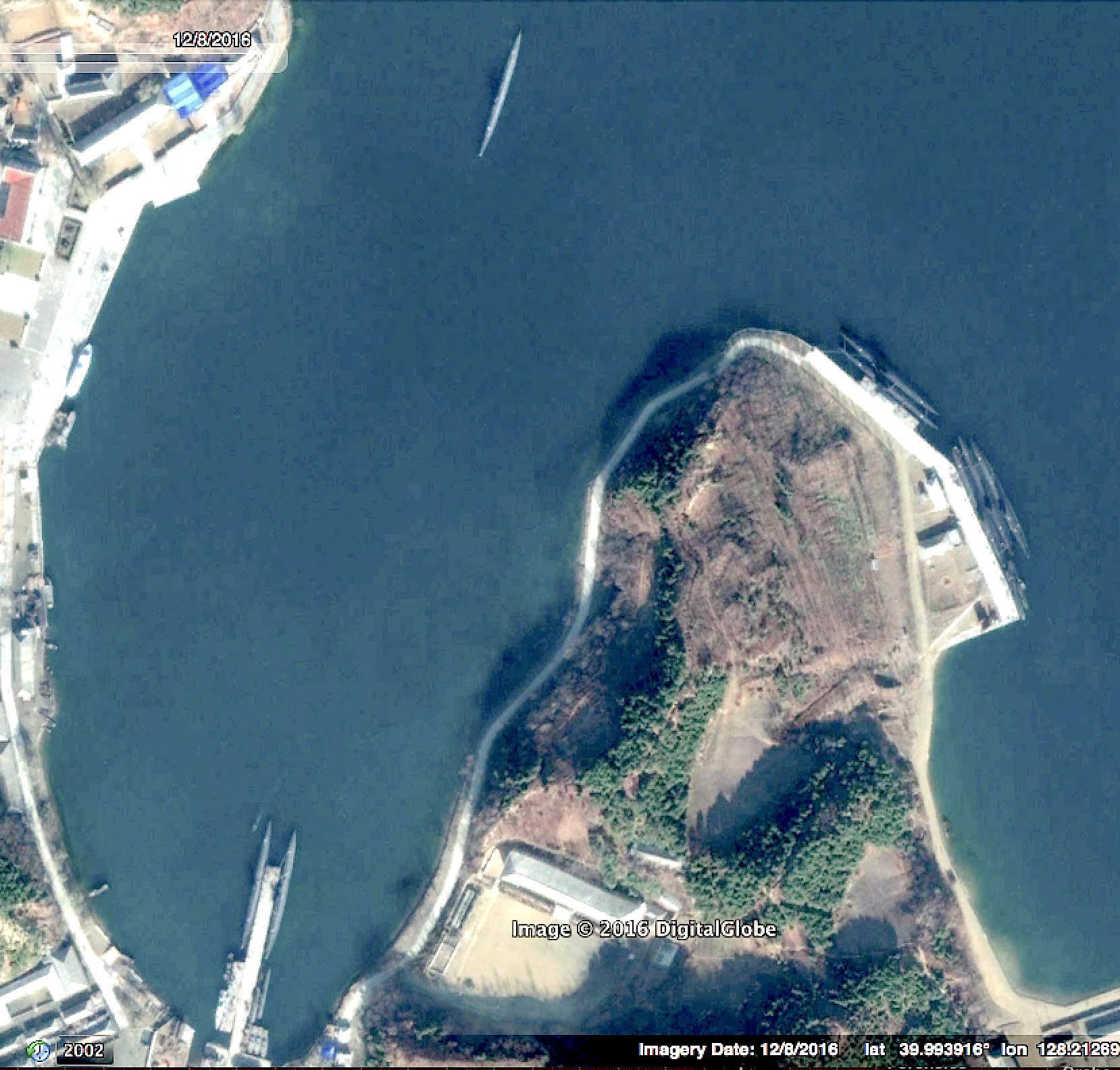
At lower left (Lat: 39.993408°, Long: 128.210340°) there is a pier that usually has several Romeos and, possibly mini-subs, moored alongside.
At middle right, (Lat: 39.996114°, Long: 128.214940°) there is a dock that usually has at least five Romeos moored alongside.
At top center in this photo, there is a Romeo, returning from patrol.
~~~~~~~~~~~~~
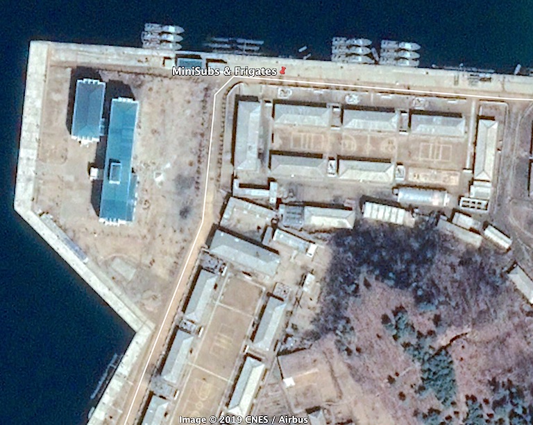
To the northeast (upper right) of this photo, at Lat: 40.000053°, Lon: 128.218490°, there s a dock complex where several minisubs and patrol boats -- plus the occasional frigate -- are usually docked:
Occasionally re-visiting the coordinates provided above, plus using Google Earth's "Time Slider" (clock icon on menu bar) can provide interesting intel re the activities of DPRK's submarine fleet.
TXnMA

26
posted on
09/21/2019 10:45:49 PM PDT
by
TXnMA
(Occam's Razor says that most conspiracist "brain farts" are simply indefensible...)
To: 2ndDivisionVet; AmericanInTokyo
"North Korea can’t build their own subway cars but you expect me to believe that they’re constructing one of the most complex machines on Earth?" For a different (illustrated) view, see # 26...
TXnMA
27
posted on
09/21/2019 10:53:58 PM PDT
by
TXnMA
(Occam's Razor says that most conspiracist "brain farts" are simply indefensible...)
To: TXnMA
Thanks! I keep track of the Russian Navy’s facilities via Google Earth, and, now, I can keep tabs on the DPRK’s naval facilities.
28
posted on
09/22/2019 10:37:49 AM PDT
by
Army Air Corps
(Four Fried Chickens and a Coke)
To: Army Air Corps; John Robinson; KitJ
"Thanks! I keep track of the Russian Navy’s facilities via Google Earth, and, now, I can keep tabs on the DPRK’s naval facilities." ~~~~~~~~~~~~
You're welcome!
RE http://www.freerepublic.com/focus/f-news/3779961/posts?page=26#26:
I haven't yet figured out how to share .KML files via FR - have you?
That would be a huge improvement:
- FR wouldn't have to use bandwidth sharing all those images.
- I wouldn't have to go through the image processing, FTPing, etc. -- and use up bandwidth by hosting them on my own server.
- You'd have clickable KML "Placemark" files that, when clicked, would "drop you right in on" exactly the Google Earth view I'm observing.
- You automatically would have files in your G-E "KML Catalog" that would allow you to review those same locations (across time) whenever you wanted to...
- And -- each "Placemark 'push-pin" file would only be <5Kb -- total!
~~~~~~~~~~~~
For example, the 1,749 byte (un-compressed) KML file for a close-up view of the USS Pueblo --
docked in the middle of Pyongyang as a propaganda attraction -- looks like this...
~~~~~~~~~~~~
<?xml version="1.0" encoding="UTF-8"?>
<kml xmlns="http://www.opengis.net/kml/2.2" xmlns:gx="http://www.google.com/kml/ext/2.2" xmlns:kml="http://www.opengis.net/kml/2.2" xmlns:atom="http://www.w3.org/2005/Atom">
<Document>
	<name>KmlFile
	<StyleMap id="m_ylw-pushpin170">
		<Pair>
			<key>normal
			<styleUrl>#s_ylw-pushpin022
		</Pair>
		<Pair>
			<key>highlight
			<styleUrl>#s_ylw-pushpin_hl04
		</Pair>
	</StyleMap>
	<Style id="s_ylw-pushpin022">
		<IconStyle>
			<scale>1.1
			<Icon>
				<href>http://maps.google.com/mapfiles/kml/pushpin/ylw-pushpin.png
			</Icon>
			<hotSpot x="20" y="2" xunits="pixels" yunits="pixels"/>
		</IconStyle>
	</Style>
	<Style id="s_ylw-pushpin_hl04">
		<IconStyle>
			<scale>1.3
			<Icon>
				<href>http://maps.google.com/mapfiles/kml/pushpin/ylw-pushpin.png
			</Icon>
			<hotSpot x="20" y="2" xunits="pixels" yunits="pixels"/>
		</IconStyle>
	</Style>
	<Placemark>
		<name>USS Pueblo
		<LookAt>
			<gx:TimeStamp>2017-04-23

			<gx:ViewerOptions>
				<gx:option name="historicalimagery">
				<gx:option enabled="0" name="sunlight">
				<gx:option enabled="0" name="streetview">
			</gx:ViewerOptions>
			<longitude>125.7397300505579
			<latitude>39.04048652047991
			<altitude>0
			<heading>-3.662677217177532e-05
			<tilt>0
			<range>133.9595895479009
			<gx:altitudeMode>relativeToSeaFloor
		</LookAt>
		<styleUrl>#m_ylw-pushpin170
		<Point>
			<gx:drawOrder>1
			<coordinates>125.73973,39.040487,0
		</Point>
	</Placemark>
</Document>
</kml>
...and, when clicked on, produces a view like this:

~~~~~~~~~
John, I do this all the time with my archeological clients via e-mail.
Do you see any way we could exchange these little files via FR?
Many thanks!
TXnMA
29
posted on
09/22/2019 1:23:45 PM PDT
by
TXnMA
(Occam's Razor says that most conspiracist "brain farts" are simply indefensible...)
To: TXnMA
30
posted on
09/22/2019 4:11:32 PM PDT
by
AmericanInTokyo
(North Korea threads on FreeTrumpublic used to be pretty good back in the day when we were realists)
Navigation: use the links below to view more comments.
first previous 1-20, 21-30 last
Disclaimer:
Opinions posted on Free Republic are those of the individual
posters and do not necessarily represent the opinion of Free Republic or its
management. All materials posted herein are protected by copyright law and the
exemption for fair use of copyrighted works.
FreeRepublic.com is powered by software copyright 2000-2008 John Robinson