Posted on 10/05/2016 11:26:21 AM PDT by PJ-Comix
000
WTNT34 KNHC 051741
TCPAT4
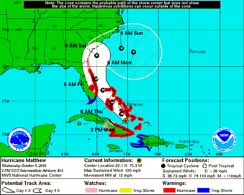
BULLETIN HURRICANE MATTHEW INTERMEDIATE ADVISORY NUMBER 30A NWS NATIONAL HURRICANE CENTER MIAMI FL AL142016 200 PM EDT WED OCT 05 2016
...SEVERE HURRICANE MATTHEW BEARING DOWN ON THE BAHAMAS AND AIMING TOWARD FLORIDA...
SUMMARY OF 200 PM EDT...1800 UTC...INFORMATION ---------------------------------------------- LOCATION...22.1N 75.3W ABOUT 70 MI...115 KM NNE OF CABO LUCRECIA CUBA ABOUT 70 MI...115 KM S OF LONG ISLAND BAHAMAS MAXIMUM SUSTAINED WINDS...120 MPH...195 KM/H PRESENT MOVEMENT...NW OR 325 DEGREES AT 12 MPH...19 KM/H MINIMUM CENTRAL PRESSURE...963 MB...28.44 INCHES
WATCHES AND WARNINGS -------------------- CHANGES WITH THIS ADVISORY:
The Government of the Bahamas has discontinued the Tropical Storm Warning for the Turks and Caicos Islands.
SUMMARY OF WATCHES AND WARNINGS IN EFFECT:
A Hurricane Warning is in effect for... * Cuban provinces of Guantanamo, Santiago de Cuba, Holguin, Granma, and Las Tunas * Southeastern Bahamas, including the Inaguas, Mayaguana, Acklins, Crooked Island, Long Cay, and Ragged Island * Central Bahamas, including Long Island, Exuma, Rum Cay, San Salvador, and Cat Island * Northwestern Bahamas, including the Abacos, Andros Island, Berry Islands, Bimini, Eleuthera, Grand Bahama Island, and New Providence * North of Golden Beach to the Flagler/Volusia county line * Lake Okeechobee
A Hurricane Watch is in effect for... * Cuban province of Camaguey * North of the Flagler/Volusia county line to Fernandina Beach
A Tropical Storm Warning is in effect for... * Haiti * Chokoloskee to Golden Beach * Florida Keys from Seven Mile Bridge eastward * Florida Bay
Interests elsewhere in the Florida Peninsula and the Florida Keys should monitor the progress of Matthew.
The Hurricane Watch and Hurricane Warning for Cuba will likely be discontinued later today.
For storm information specific to your area in the United States, including possible inland watches and warnings, please monitor products issued by your local National Weather Service forecast office. For storm information specific to your area outside the United States, please monitor products issued by your national meteorological service.
DISCUSSION AND 48-HOUR OUTLOOK ------------------------------ At 200 PM EDT (1800 UTC), the eye of Hurricane Matthew was located near latitude 22.1 North, longitude 75.3 West. Matthew is moving toward the northwest near 12 mph (19 km/h), and this motion is expected to continue during the next 24 to 48 hours. On this track, Matthew will be moving across the Bahamas today and tomorrow, and is expected to be very near the east coast of Florida by Thursday evening.
Maximum sustained winds are near 120 mph (195 km/h) with higher gusts. Matthew is a category 3 hurricane on the Saffir-Simpson Hurricane Wind Scale. Some strengthening is forecast during the next couple of days, and Matthew is expected to remain at category 3 or stronger while it moves through the Bahamas and approaches the east coast of Florida.
Hurricane-force winds extend outward up to 45 miles (75 km) from the center and tropical-storm-force winds extend outward up to 175 miles (280 km).
The minimum central pressure reported by an Air Force Hurricane Hunter plane was 963 mb (28.44 inches).
HAZARDS AFFECTING LAND ---------------------- WIND: Hurricane conditions will continue to gradually diminish over portions of eastern Cuba today. These conditions will continue over the southeastern Bahamas, and will spread over the central Bahamas later today and the northwestern Bahamas tonight.
Hurricane conditions are expected to first reach the hurricane warning area in Florida by late Thursday and will spread northward Thursday night and Friday. Tropical storm conditions are first expected in Florida by early Thursday.
RAINFALL: Matthew is expected to produce total rainfall amounts in the following areas:
Southern Haiti and southwestern Dominican Republic...15 to 25 inches, isolated 40 inches Eastern Cuba and northwestern Haiti...8 to 12 inches, isolated 20 inches Eastern Jamaica...additional 1 to 2 inches, isolated storm totals 12 inches The Bahamas...8 to 12 inches, isolated 15 inches Turks and Caicos Islands...2 to 5 inches, isolated 8 inches Northeastern Haiti and the Northern Dominican Republic...1 to 3 inches, isolated 5 inches Coastal east-central Florida....4 to 7 inches, isolated 10 inches Florida Keys....1 to 3 inches, isolated 5 inches
Life-threatening flash floods and mudslides are likely in southern and northwestern Haiti, the southwestern Dominican Republic, and eastern Cuba.
STORM SURGE: The combination of a dangerous storm surge and large and destructive waves could raise water levels by as much as the following amounts above normal tide levels...
Northern Coast of Cuba east of Camaguey...4 to 6 feet The Bahamas...10 to 15 feet
The water could reach the following heights above ground if the peak surge occurs at the time of high tide...
North Palm Beach to the Flagler/Volusia county line...3 to 5 ft
Surge-related flooding depends on the relative timing of the surge and the tidal cycle, and can vary greatly over short distances. Large waves generated by Matthew will cause water rises to occur well in advance of and well away from the track of the center.
The combination of a dangerous storm surge and the tide will cause normally dry areas near the coast to be flooded by rising waters moving inland from the shoreline. There is a danger of life-threatening inundation during the next 36 hours along the Florida east coast from North Palm Beach to the Flagler/Volusia county line. There is the possibility of life-threatening inundation during the next 48 hours from north of the Flagler/Volusia county line to Fernandina Beach. For a depiction of areas at risk, please see the Prototype National Weather Service Storm Surge Watch/Warning Graphic. For information specific to your area, please see products issued by your local National Weather Service forecast office.
The Prototype Storm Surge Watch/Warning Graphic is a depiction of areas that would qualify for inclusion under a storm surge watch or warning currently under development by the National Weather Service and planned for operational use in 2017. The Prototype Graphic is available at hurricanes.gov.
SURF: Swells generated by Matthew will continue to affect portions of the coasts of Hispaniola, eastern Cuba, and the Bahamas during the next few days, and will spread northward along the east coast of Florida and the southeast U.S. coast tonight and Thursday. These swells are likely to cause life-threatening surf and rip current conditions. Please consult products from your local weather office.
NEXT ADVISORY ------------- Next complete advisory at 500 PM EDT.
$$ Forecaster Avila
God Bless and God Speed to those in the affect areas.
The very latest models apparently show this hurricane very shortly to take a sharp right turn towards the east and head out into the ocean away from land.
I think the will get no closer than 50 miles from Broward but counties further norther might have a closer brush. Fortunately the east side of this hurricane is the “weak” side.
Rush just said it has shifted West?
That is what I had just heard.
Spaghetti models are all over the place. The 5pm update may be verry different.
http://www.sfwmd.gov/portal/page/portal/xweb%20weather/hurricane%20model%20plots
One of those strands shows it going right thru me. Another one shows it following the ‘92 Hurricane Andrew path. Most show it going about 50 miles east of Ft. Lauderdale.
I’ll bet if they increased the price to $75 you’d be able to get a tank.
I got into an argument with eastforker a few weeks ago about the economic intelligence of raising prices during catastrophes, like a hurricane.
My contention, and that of many economists is that if prices are increased in the danger zones, people will not hoard.
I’d guess that many people loaded up their propane tanks to levels far beyond what they’ll need for a couple days of power loss leaving folks like you with nothing.
Had they raised the price to $75, the hoarders would realize that a tank, or a half tank will last them through the situation rather than getting all three tanks topped off.
Same with gasoline. Kick the price to $8 a gallon, most people will buy 4-5 gallons, enough to get them to their evacuation safe area where they can top off and the gas station tanks can be refilled.
Most gas stations get refilled at least daily. If there was no price increase, the first to get the gas would fill up, leaving the rest to weather the storm and maybe die.
When Ike hit the Texas coast I lived there without power for 2 weeks. my late wife and I weathered through the storm. She was on an oxygen machine. Thank goodness your policy was not in effect. A few days before the storm hit, I was able to buy enough gasoline to power my generator and have power to operate her machine, I would have never been able to do that at your ridiculous idea of $8 a gallon.
It’s always the ones who don’t take the TIME necessary to prepare way before everyone reaches the panic stage who complain the loudest that someone else had the foresight to do so.
Reminds me of that Twilight Zone episode, "The Shelter."
The very latest models apparently show this hurricane very shortly to take a sharp right turn towards the east and head out into the ocean away from land.
Not until it gets to the carolinas. Still looks like it will scrape the East Coast of FL with the eye just off shore.
Well it has shifted to the west as has been predicted all along. But the long range is
for it to stay along the east coast of Florida and eventual turn back east. Some
even show a poetential loop 6 or more days out but that is way to far out to be accurate.
If this hurricane makes landfall somewhere along the east coast of FL it will be the first
October hurricane to do so since Hurricane King in 1950.
Is it possible for this hurricane to stay in the cone veering back out into the Atlantic, then continue due west to hit the central Florida coast again?
Who knows what it’s going to do if that circle begins. You’d think it would head on
to the north. What is needed is a good front from the west to push it on out to the atlantic.
You were smart, and in your situation, need to think ahead. My “ridiculous idea” as you call it is to help those less prescient.
Did you read the article I sent you?
Something like that happened here about 12 years ago.
Disclaimer: Opinions posted on Free Republic are those of the individual posters and do not necessarily represent the opinion of Free Republic or its management. All materials posted herein are protected by copyright law and the exemption for fair use of copyrighted works.