Posted on 09/08/2015 3:52:48 PM PDT by Stand Watch Listen
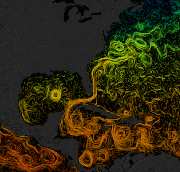
For folks who got super-excited when Google Earth came out, here’s another 3-D model of the world with similarly awesome potential. It’s called the Science on a Sphere Explorer, and it lets you view tons of animated planetary data, from the age of the sea floor to the airborne migration of CO2 to hurricane tracks dating back to 1950.
Science on a Sphere is a NOAA tool that projects different layers on a huge ball, creating a virtual earth you can walk around in museums and classrooms. It’s now available as a desktop program for Windows and Mac, so you can probe natural (and unnatural) phenomena from home in popping, 1920x1080 resolution. Be warned it’s a huge download that eats up to 15 gigs of hard-drive space, though those willing to be patient will reap fantastic rewards.
Here are a few of the ways you can explore the planet. Note you can rotate the screen to find and zoom in on any spot on earth. This is the basic Blue Marble view with real-time clouds—peep all those hurricanes in the Pacific:………………………………………”
(Excerpt) Read more at govexec.com ...
is this good data or the global warming scrubbed data?
Top gif is so cool!!!
Is it on fire?
You get to pick! But it's not totally your choice. The difference is, Google can't fool other people into giving away your money, but NOAA can fool other people into giving away your freedom and your life.
Preachin' to the choir!
The Bermuda Triangle is easy to see in the bottom picture.
Thanks for the post.
A Desk Top model.
Is that for a Flat Earth?
Sweet! Thanks!
Disclaimer: Opinions posted on Free Republic are those of the individual posters and do not necessarily represent the opinion of Free Republic or its management. All materials posted herein are protected by copyright law and the exemption for fair use of copyrighted works.