
Posted on 04/28/2014 4:51:07 PM PDT by tcrlaf
Tornado passed just south of Downtown, and the Airport. Currently over Brandon. At least one other also active in the area.
SEVERE WEATHER STATEMENT NATIONAL WEATHER SERVICE JACKSON MS 634 PM CDT MON APR 28 2014
MSC049-121-290015- /O.CON.KJAN.TO.W.0052.000000T0000Z-140429T0015Z/ RANKIN MS-HINDS MS- 634 PM CDT MON APR 28 2014
...A TORNADO WARNING REMAINS IN EFFECT FOR EXTREME EAST CENTRAL HINDS AND CENTRAL RANKIN COUNTIES UNTIL 715 PM CDT...
AT 634 PM CDT...A CONFIRMED LARGE AND EXTREMELY DANGEROUS TORNADO WAS LOCATED NEAR RICHLAND...AND MOVING EAST AT 35 MPH.
THIS IS A PARTICULARLY DANGEROUS SITUATION.
HAZARD...DAMAGING TORNADO.
SOURCE...RADAR CONFIRMED TORNADO.
IMPACT...YOU ARE IN A LIFE THREATENING SITUATION. FLYING DEBRIS WILL BE DEADLY TO THOSE CAUGHT WITHOUT SHELTER. MOBILE HOMES WILL BE DESTROYED. CONSIDERABLE DAMAGE TO HOMES...BUSINESSES AND VEHICLES IS LIKELY AND COMPLETE DESTRUCTION POSSIBLE.
THE TORNADO WILL BE NEAR... PEARL AND FLOWOOD AROUND 640 PM CDT. BRANDON AROUND 650 PM CDT. PELAHATCHIE AROUND 710 PM CDT.
PRECAUTIONARY/PREPAREDNESS ACTIONS...
TO REPEAT...A LARGE...EXTREMELY DANGEROUS AND POTENTIALLY DEADLY TORNADO IS ON THE GROUND.
Weather channel:
Heavy damage reported in Richland, Jackson suburb.
Weather Channel’s Dave Malkot:
A tornado just missed the National Weather Service station in Jackson, MS 1 minute ago. Everyone is reporting in OK.
Four confirmed dead in Winston County, Miss., 16WAPTNews in Jackson, Miss., is reporting.
https://twitter.com/Kingfish1935
https://twitter.com/WLBT_DKenney/status/460909119029792768/photo/1
Pic is of the Winston County hospital that got a direct hit. Windows blown, walls down, cars flipped and stacked in the parking lot.
NWS Jackson MS
The tornado passed south of our office. Radar also still spinning (fingers-crossed). We are in good shape and fully operational.
Prayers for all in the south enduring this weather. Keeping family and friends in prayer
I would have been in free-wheel by now.
Whew, springtime north of the Gulf is a bitch.
Its headed for Atlanta. We have battened down the hatches. Hope it loses steam on the way here.
North AL and Southern TN have seen tornado after tornado today and it is not over. A newsman said 3 were killed near Athens. Another warning over in west AL. One was Marion County and I thnk the newsman said Winston County was the other one but i could be wrong..Now, flood warnings are posted. He said earlier some areas are getting 2-4” an hour. This reminds me of the 1974 and 1989 storms. The storms seem to be forming in west AL and moving east. The weather coverage has been on since 3. Some storms are forming so quickly that there s no time or warnings.
This is one humungous powerful storm It’s been raining for two days from Mississippi to N. Mn,
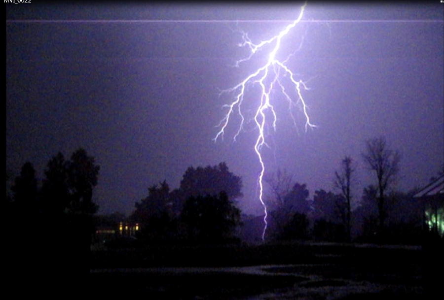
Wow. Great shot.
I got several lightning bolts on video but that was the most impressive one. We hope for NO repeat performances this evening but it looks like things are starting to fire up in the western part of the state. It’s worse in the deep south but they say southern TN could still take a hit.
I’d say a lot of us are praying for nothing worse than thunderstorms today.
Disclaimer: Opinions posted on Free Republic are those of the individual posters and do not necessarily represent the opinion of Free Republic or its management. All materials posted herein are protected by copyright law and the exemption for fair use of copyrighted works.