Skip to comments.
Officials Say Missing Malaysia Airlines Plane "Ended in the Southern Indian Ocean"
ABC ^
| 3/24/14
| Colleen Curry
Posted on 03/24/2014 7:47:49 AM PDT by TangledUpInBlue
click here to read article
Navigation: use the links below to view more comments.
first previous 1-20 ... 41-60, 61-80, 81-100, 101-120 last
To: Yosemitest
The Malaysian military has already admitted that they painted it at 2:15 on a northwest heading to waypoint IGREX.
And that is just 4 minutes after its 2:11 satellite ping that calculated it at that same point — shaking the Malaysians out of their malaise of denial while others have not.
To: TangledUpInBlue; a fool in paradise
We oughta have a thread dedicated to all the weasel excuses from the proponents of the silly theories. Fun for sadists!
102
posted on
03/24/2014 11:24:24 AM PDT
by
Revolting cat!
(Badwhereas things are wrong! Ice cream is delicious! We reserve the right to serve refuse to anyone!)
To: Uncle Chip
Thank you for noticing that "INCONVENIENT FACT".
103
posted on
03/24/2014 11:24:36 AM PDT
by
Yosemitest
(It's Simple ! Fight, ... or Die !)
To: Yosemitest
and what would that be????
To: chopperman
>>I wonder if Inmarsat checked for a Dopler shift to detect the direction of the plane.<<
According to the Wall Street Journal article I read, they did use the Doppler Effect. That’s how they calculated a separate data stream from the pings.
Apparently the ping return time gave them the distance from the satellite at each ping (1:11, 2:11......8:11) from which the generated the arcs indicating possible positions at the last ping at 8:11.
Then they looked at the frequency shift of the pings themselves and derived information on how fast the plane was going relative to the satellite. The frequency changes would be due to the Doppler Effect.
(The Doppler Effect is the phenomenon where the frequency of a constant sound source changes depending upon whether it’s approaching or departing. Think of how a train whistle changes in pitch as it comes at you and then goes past.)
If the plane was going abreast of the satellite on a concentric circle the ping frequency would be unchanged. If it was approaching it would be a higher frequency, and if departing a lower frequency. If it was departing at an angle it would be lower but not as low as if it were going directly away from the satellite.
They would still have to make some assumptions about the plane’s airspeed, and possibly its altitude, but if the frequency didn’t shift between several pings they could probably calculate that the plane was on a more or less straight route during that time, as opposed to circling, for example.
Combine that with the fact that they would have arcs for each hour and they could probably come up with decent estimates as to the plane’s actual location along the hourly arcs. They seem to have settled on the South Indian Ocean, but to do that (as opposed to going North) they’d have to have additional information as to it’s initial direction before it started flying on a constant heading.
I’m assuming it did finally assume a constant heading because of the tracks provided by Inmarsat. They would derive that from an unchanging frequency of the hourly pings. The two tracks they provided probably assumed a range of air speed of the plane, high and low end.
It would be interesting to learn how they decided on the southern option, as opposed to the northern one, as their second data stream wouldn’t sort that out.
105
posted on
03/24/2014 11:28:17 AM PDT
by
Norseman
(Defund the Left-Completely!)
To: Yosemitest
BTW FYI:
The latest calculations were based on a new analysis of the satellite-operator’s original data, relying on minute changes in the frequency of the electronic “pings”—or attempts to link up with satellites—received from the plane during its more than six-hour flight after dropping off radar, according to Tim Farrar, a satellite industry consultant.
Inmarsat was able to correlate two streams of data to form a more precise picture of where the Boeing 777 may have ended up, Mr. Farrar said. The initial data stream focused on the timing of the “pings” from the plane, he said, revealing distance from the satellite. The later stream focused on frequency changes involving the “Doppler effect,” he said, revealing the plane’s speed.
The Doppler effect has to do with changes in the frequency of a moving source of waves relative to an observer.
“It shows there is a lot more information hidden in what appears to be simple satellite data,” Mr. Farrar said. The latest analysis also indicated “there is a higher likelihood of the plane ending up in certain parts” of the southern arc.
http://www.freerepublic.com/focus/f-news/3136787/posts
To: Revolting cat!
Oh, nobody needs to eat any crow for my sake. A lot of people have gotten tipsy on conspiracy cocktail over the last bit and I just hope they’re sobering up a little. The last verifiable communication of any kind at with this airplane indicated something along these very lines occurred. There was no hard evidence to indicate otherwise. There was conjecture, opinion, and, wild imaginations conjuring up scenarios to the contrary but not hard evidence. Who? Why? How? We don’t know yet but the “where” was starting to firm up.
As for those saying they won’t believe it until wreckage is discovered and displayed I wouldn’t hold my breath. There may not be enough of this thing left on the surface to fill a gallon Ziploc bag.
107
posted on
03/24/2014 11:36:18 AM PDT
by
FAA
To: Uncle Chip
You didn't click on the
"To 101" below my comment, to read the comment I was responding to, to find out ?
108
posted on
03/24/2014 11:39:29 AM PDT
by
Yosemitest
(It's Simple ! Fight, ... or Die !)
To: Yosemitest
You didn't click on the "To 101" below my comment, to read the comment I was responding to, to find out ? I sure did but your comment is unclear and nonspecific --
To what "Inconvenient Fact" are you referring in post 101?
To: Uncle Chip
Thanks for the link, and after reading more on the
"Doppler effect" and reading all of the linked article you provided, I sill
don"t buy it.
The math just doesn't add up,
and I'd want to know more about Prime Minister Najib Razak, and the other reasons WHY he might make such a statement.
Does he actually believe what he said ?
Who stands to gain by his dropping of the search for MH370?
No, I don't buy it at all.
110
posted on
03/24/2014 11:48:29 AM PDT
by
Yosemitest
(It's Simple ! Fight, ... or Die !)
To: Uncle Chip
The FACT that:
The Malaysian military has ALREADY ADMITTED that they painted it at 2:15 ON A NORTHWEST HEADING to waypoint IGREX.
And that is just 4 minutes AFTER its 2:11 satellite pingthat calculated it at that same point
—SHAKING the Malaysians OUT of their malaise OF DENIAL
Does that make it any easier for you ?
Their last OBSERVED "Direction of travel" was
NORTHWEST BOUND .
How simpler can it get?
111
posted on
03/24/2014 11:57:58 AM PDT
by
Yosemitest
(It's Simple ! Fight, ... or Die !)
To: Yosemitest
Their last OBSERVED "Direction of travel" was NORTHWEST BOUND . How simpler can it get?The operative word there being "was" --
It never made it to IGREX but turned before it got there.
And Doppler showed it to have turned south [toward the satellite] -- not north [away from the satellite].
To: Norseman
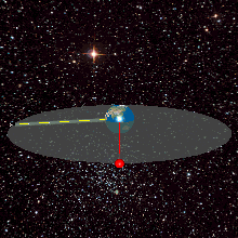
“The red lines (arcs) don’t indicate the path of the plane. They indicate the possible locations of the plane at 8:11, when the last ping was received (anywhere along the arc at that particular time, 8:11)”
I understand. That’s my point. I don’t know exactly. Just looking at the map I would guess each of the arcs are over a 1000 miles long. In other words....a big ass damn guess. Heck I could do that and I don’t even OWN a satellite!
113
posted on
03/24/2014 12:16:02 PM PDT
by
saleman
To: Uncle Chip
IF you believe them about the "Doppler Effect" and the "transmission" getting stronger through those "handshakes".
But I don't buy that.
114
posted on
03/24/2014 2:58:57 PM PDT
by
Yosemitest
(It's Simple ! Fight, ... or Die !)
To: Revolting cat!
So was this simply wrong-way corigan (pilot error) or malicious intent from the pilot(s) turning off communications, nothing unusual in last report?
115
posted on
03/24/2014 3:26:45 PM PDT
by
a fool in paradise
(The Texas judge's decision was to pave the way for same sex divorce for two Massachusetts women.)
To: saleman
116
posted on
03/24/2014 3:28:59 PM PDT
by
Yosemitest
(It's Simple ! Fight, ... or Die !)
To: TangledUpInBlue
I think it had to do with different satellites and the time that different pings reached them in impossible fractions of seconds. Then some math applied to determine what that meant in terms of satellite positions.
I read this someplace and now I can’t find it. If I’m wrong, I’m very sorry.
117
posted on
03/24/2014 3:33:02 PM PDT
by
xzins
( Retired Army Chaplain and Proud of It! Those who truly support our troops pray for victory!)
To: Yosemitest
IF you believe them about the "Doppler Effect"
Doppler has a better reputation and is better known than the General's unnamed covert nonexistent sources.
To: Uncle Chip
Says WHO ?
Better safe than sorry.¯br> I believe the military sources.
If they were serious about finding the wreckage and floating debris, they'd send the Predator UAVs out over the search area, with their 30-hours loiter over target time.
119
posted on
03/24/2014 4:32:34 PM PDT
by
Yosemitest
(It's Simple ! Fight, ... or Die !)
To: TangledUpInBlue
Yeah and they got another 50 people inflight as well.
120
posted on
03/24/2014 8:06:01 PM PDT
by
Jaded
(Really? Seriously?)
Navigation: use the links below to view more comments.
first previous 1-20 ... 41-60, 61-80, 81-100, 101-120 last
Disclaimer:
Opinions posted on Free Republic are those of the individual
posters and do not necessarily represent the opinion of Free Republic or its
management. All materials posted herein are protected by copyright law and the
exemption for fair use of copyrighted works.
FreeRepublic.com is powered by software copyright 2000-2008 John Robinson
 "Telecommunications satellites, as well as other types of satellites, maintain a geosynchronous orbit known as the Clarke orbit.