Free Republic
Browse · Search
News/Activism
Topics · Post Article

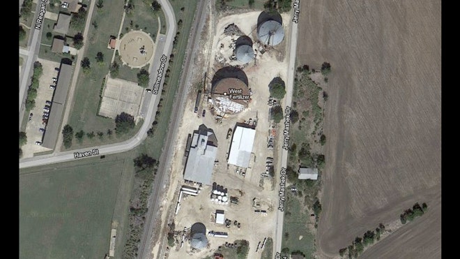
Go to google maps for West Texas, look just to the east of mile marker 354 you’ll see a school facility and foot ball field. Then look north across the street about 500 ft and that is the West Fertilizer Plant. Put Google Maps on Satellite and you’ll see the tanks, etc.

Lots of residential buildings in that area.

https://maps.google.com/maps?oe=utf-8&client=firefox-a&q=west+texas&ie=UTF-8&hq=&hnear=0x864f7566cf0ca5c7:0xfb25f7a61ca24545,West,+TX&gl=us&ei=0WZvUZrvG_K24AO3_oB4&ved=0CKsBELYD


88 posted on 04/17/2013 8:28:20 PM PDT by deport
[ Post Reply | Private Reply | To 1 | View Replies ]


To: deport

99 posted on 04/17/2013 8:35:53 PM PDT by deport
[ Post Reply | Private Reply | To 88 | View Replies ]

Free Republic
Browse · Search
News/Activism
Topics · Post Article


FreeRepublic, LLC, PO BOX 9771, FRESNO, CA 93794
FreeRepublic.com is powered by software copyright 2000-2008 John Robinson