Free Republic
Browse · Search
News/Activism
Topics · Post Article

To: Stonewall Jackson

La Moure County grounding was due to the the nav team plotting GPS fixes that were in WGS-84 datum on a paper chart that used a local datum so positions were off. Lots of lessons learned messages from that one.

26 posted on 01/30/2013 10:03:01 PM PST by GATOR NAVY
[ Post Reply | Private Reply | To 25 | View Replies ]


To: GATOR NAVY
Kind of like the Honda Point Disaster back in 1923, when the navigator of the lead destroyer failed to realize that a massive earthquake a week earlier had caused severe current fluctuations in the area. The fourteen ships of DESRON 11 turned and charged full speed onto the rocks at Honda Point instead of into the Santa Barbara Channel.

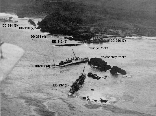
Seven destroyers were lost, two were damaged, and twenty-three sailors died in the fiasco.


27 posted on 01/30/2013 10:42:30 PM PST by Stonewall Jackson (Molon Labe!)
[ Post Reply | Private Reply | To 26 | View Replies ]

Free Republic
Browse · Search
News/Activism
Topics · Post Article


FreeRepublic, LLC, PO BOX 9771, FRESNO, CA 93794
FreeRepublic.com is powered by software copyright 2000-2008 John Robinson