Skip to comments.
Feds to solicit public's voice to develop use plan for NPR-A
The Anchorage Daily News ^
| June 18th, 2005
| Associated Press
Posted on 06/18/2005 9:20:05 AM PDT by thackney
FAIRBANKS -- A federal agency is developing a use plan for a section of the National Petroleum Reserve-Alaska.
The plan covers 9.2 million acres in the southwest portion of the 23 million-acre reserve, which encompasses most of the western half of Alaska's North Slope.
The Bureau of Land Management has opened a "scoping" period in which members of the public can identify issues and suggest how the land should be used.
A public meeting will be held Aug. 10 in Fairbanks. Meetings also will be held in 13 Northwest Alaska villages and in Anchorage between July 18 and Aug. 11. The planning process will continue through late 2009.
Over the past decade, the BLM completed plans for and sold oil leases in the northwest and northeast planning areas of the reserve. The plans drew protests and lawsuits from environmental groups who said the agency gave too little consideration to wildlife and too much to oil and gas development.
The oil and gas potential in the new planning area is lower than in the northern areas, the BLM said in a planning newsletter.
In contrast to the flat wetlands and lakes that cover most of the northeast and northwest areas, the southern section contains relatively dry uplands rising to the foothills and mountain peaks of the Brooks Range. The Colville River's headwaters lie in the center of the area.
"The south plan area includes important surface values that the BLM wants to protect," according to the newsletter. "Much of the western two-thirds of the area comprises the calving grounds for the Western Arctic Caribou Herd."
Two dozen villages hunt caribou from the herd, it noted. Congress has mandated protection already for the Utukok uplands in the central region. The Colville River also is partially covered by a special use area.
(Excerpt) Read more at adn.com ...
TOPICS: News/Current Events; US: Alaska
KEYWORDS: alaska; crudeoil; npra; oil
As of early 2003:
Created in 1923 by President Harding, the petroleum reserve has been specifically designated by Congress for energy production. In fact, the petroleum reserve has a history of lease sales, exploration and drilling activity. More than 20,000 miles of seismic data has been acquired within its 23-million-acres, and 12 wells have been drilled since 1999. Since the latest NPRA lease sale, seismic testing and exploration drilling has complied with stringent local, state and federal requirements.
1
posted on
06/18/2005 9:20:05 AM PDT
by
thackney
To: thackney
So what is their question...or did I miss it. If they are saying they don't need it for oil exploration, then leave it alone.
2
posted on
06/18/2005 9:24:36 AM PDT
by
marty60
To: marty60
Since when does the BLM get to decide if "they" need the oil? That land belongs to Americans and it was specifically set aside for energy development.
From the U.S. Geological Survey 2002 Petroleum Resource Assessment of the National Petroleum Reserve in Alaska (NPRA):
A new USGS assessment concludes that NPRA holds signicantly greater petroleum resources than previously estimated. Technically recoverable, undiscovered oil beneath the Federal part of NPRA likely ranges between 5.9 and 13.2 billion barrels, with a mean (expected) value of 9.3 billion barrels. An estimated 1.3 to 5.6 billion barrels of those technically recoverable oil resources is economically recoverable at market prices of $22 to $30 per barrel. Technically recoverable, undiscovered nonassociated natural gas for the same area likely ranges between 39.1 and 83.2 trillion cubic feet, with a mean (expected) value of 59.7 trillion cubic feet. The economic viability of this gas will depend on the availability of a natural-gas pipeline for transport to market.
http://geopubs.wr.usgs.gov/fact-sheet/fs045-02/
3
posted on
06/18/2005 9:58:24 AM PDT
by
thackney
(life is fragile, handle with prayer)
To: thackney
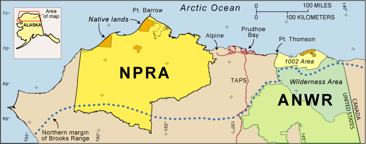
Map of northern Alaska showing locations and relative sizes of the National Petroleum Reserve in Alaska (NPRA) and the Arctic National Wildlife Refuge (ANWR). ANWR’s 1002 Area was evaluated for petroleum potential by the USGS in 1998. The Trans-Alaska Pipeline System (TAPS) and “feeder” pipelines extending east and west of Prudhoe Bay show the extent of existing petroleum infrastructure. Locations of the Alpine and Prudhoe Bay oil fields and the Point Thomson gas and oil accumulation also are shown.
4
posted on
06/18/2005 9:59:41 AM PDT
by
thackney
(life is fragile, handle with prayer)
To: thackney
In other words they are bending over for the crazies. If it is committed to oil exploration THAT is what it should be used for. anyway, it will HAVE to be used, with the very real possibility of Islamofascist using OIL as a weapon against us.
5
posted on
06/18/2005 10:02:10 AM PDT
by
marty60
To: thackney
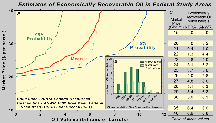
Figure 7. Summary of the 2002 U.S. Geological Survey (USGS) estimate of economically recoverable oil that may occur beneath the Federal part of NPRA. A , Graph relating market price to the volume of oil estimated to be profi tably recoverable. The three curves are based on estimates of technically recoverable oil volumes at the mean (expected) value, and at the 95% (F95) and 5% (F05) probabilities. The 95% probability level means that there is a 19 in 20 chance that the amount economically recoverable will be at least as large as the amount shown; the 5% probability level means that there is a 1 in 20 chance that the amount economically recoverable will be at least as large as the amount shown. Included are the costs of fi nding, developing, producing, and transporting oil to market (West Coast of the lower-48 States) based on a 12% after-tax return on investment, all calculated in constant 2001 dollars. The chart is read as follows: At a market price of $25 per barrel, there is a 95% probability of at least 1.6 billion barrels of economically recoverable oil and a 5% probability of at least 6.2 billion barrels. The mean or expected value is at least 3.7 billion barrels of economically recoverable oil. So that estimates of economically recoverable oil for the NPRA can be compared with those for the ANWR 1002 Area, the graph shows the mean curve (dashed line) from the 1998 USGS assessment of ANWR Federal lands, which was calculated in constant 1996 dollars. B , Histograms showing the expected (mean) numbers of oil accumulations estimated to exist in various size categories of technically recoverable oil resources in the 2002 USGS assessment of NPRA (dark green) and in the 1998 USGS assessment of ANWR (light green). Note that each size class is twice as big as the next smaller size class. The ANWR area is estimated to contain more accumulations in the largest two size classes shown, whereas the NPRA area is estimated to contain more accumulations in all the smaller size classes. C , Table of economically recoverable oil resources estimated to occur in the Federal parts of NPRA and ANWR assessment areas at various market prices. Values are based on the mean curves shown in A . NPRA results are calculated in constant 2001 dollars, whereas ANWR results are calculated in constant 1996 dollars.
------------------------------
Keep this chart in mind when you hear people claiming it is not worth developing based on data a few years old. A few years ago these studies did not even cosider the possibility of oil even close to Fridays close of $55.87.

6
posted on
06/18/2005 10:06:11 AM PDT
by
thackney
(life is fragile, handle with prayer)
To: thackney
I suggest they set aside a large area for caribou breeding complete with beds, booze, music, and cigarettes. We needs them caribous to be happy. Oil is a luxury, happy caribou are a necessity.
7
posted on
06/18/2005 9:48:39 PM PDT
by
Mind-numbed Robot
(Not all that needs to be done needs to be done by the government.)
To: Mind-numbed Robot
Caribou love drilling.
Over four decades of development on the North Slope have shown that caribou can co-exist with development. The Central Arctic Herd, which calves in the Prudhoe Bay and Kuparuk oil fields, has increased from 3,000 animals to more than 23,400 animals. Facilities in the Coastal Plain area would be designed to protect this important species and their habitat.


8
posted on
06/19/2005 7:44:05 AM PDT
by
thackney
(life is fragile, handle with prayer)
Disclaimer:
Opinions posted on Free Republic are those of the individual
posters and do not necessarily represent the opinion of Free Republic or its
management. All materials posted herein are protected by copyright law and the
exemption for fair use of copyrighted works.
FreeRepublic.com is powered by software copyright 2000-2008 John Robinson