
Posted on 08/24/2005 2:49:15 AM PDT by STARWISE

Excerpt:
Hurricane History-NOAA:Hurricane Andrew 1992
The most destructive United States hurricane of record started modestly as a tropical wave that emerged from the west coast of Africa on August 14. The wave spawned a tropical depression on August 16, which became Tropical Storm Andrew the next day. Further development was slow, as the west-northwestward moving Andrew encountered an unfavorable upper-level trough.
Indeed, the storm almost dissipated on August 20 due to vertical wind shear. By August 21, Andrew was midway between Bermuda and Puerto Rico and turning westward into a more favorable environment. Rapid strengthening occurred, with Andrew reaching hurricane strength on the 22nd and Category 4 status on the 23rd. After briefly weakening over the Bahamas, Andrew regained Category 4 status as it blasted its way across south Florida on August 24.
The hurricane continued westward into the Gulf of Mexico where it gradually turned northward. This motion brought Andrew to the central Louisiana coast on August 26 as a Category 3 hurricane. Andrew then turned northeastward, eventually merging with a frontal system over the Mid-Atlantic states on August 28.
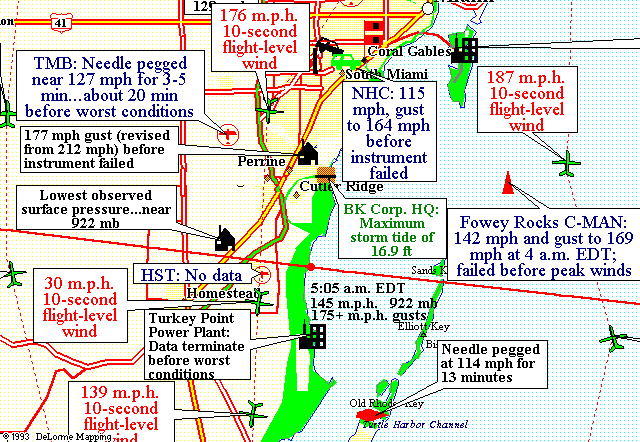
Reports from private barometers helped establish that Andrew's central pressure at landfall in Homestead, Florida was 27.23 inches, which makes it the third most intense hurricane of record to hit the United States. Andrew's peak winds in south Florida were not directly measured due to destruction of the measuring instruments. An automated station at Fowey Rocks reported 142 mph sustained winds with gusts to 169 mph (measured 144 ft above the ground), and higher values may have occurred after the station was damaged and stopped reporting.
The National Hurricane Center had a peak gust of 164 mph (measured 130 ft above the ground), while a 177 mph gust was measured at a private home. Additionally, Berwick, LA reported 96 mph sustained winds with gusts to 120 mph.
Andrew produced a 17 ft storm surge near the landfall point in Florida, while storm tides of at least 8 ft inundated portions of the Louisiana coast. Andrew also produced a killer tornado in southeastern Louisiana.
Andrew is responsible for 23 deaths in the United States and three more in the Bahamas. The hurricane caused $26.5 billion in damage in the United States, of which $1 billion occurred in Louisiana and the rest in south Florida. The vast majority of the damage in Florida was due to the winds. Damage in the Bahamas was estimated at $250 million.
=========================================================
"1992 -- The eye of Hurricane Andrew crossed Homestead Air Force Base shortly before dawn. The 16.9 foot storm surge on the coast was a record for southeast Florida. Central pressure was 27.23". Wind gusts to 164 mph damaged over 125,000 homes."
" “Andrew was a small and ferocious hurricane that brought unprecedented economic devastation along a path through the northwestern Bahamas, the southern Florida peninsula, and south-central Louisiana. Damage in the United States is estimated to be near 25 billion, ((SINCE REVISED TO $30B), making Andrew the most expensive natural disaster in U.S. history.
"The tropical cyclone struck southern Dade County, Florida, especially hard, with violent winds and storm surges characteristic of a category 4 hurricane on the Saffir/Simpson Hurricane Scale, and with a central pressure of 922 mb made it the third lowest this century for a hurricane at landfall in the United States.”


Satellite View - Off the Coast


Some Statistics:
*Winds est. 140-160+ mph – after approx. a year, damage assessments and surviving instrumentation were scrutinized, it was revealed to be a Cat. 5. Note: the 177 and 187mph gusts on the area map above
*Homestead Air Force Base was said to have been built to endure 200mph winds, yet it was destroyed, including all communications and weather instrumentation
"The military suffered too. Homestead Air Force Base was wiped out by Hurricane Andrew. The three fighter squadrons normally stationed there were moved to bases in South Carolina and Georgia. During his reelection campaign, President Bush promised to rebuild and reopen Homestead AFB. After Bill Clinton's victory, the base was closed by Defense Secretary Les Aspin. The closing caused a total economic loss to the community of 430 million dollars a year.”
*160,000+ people in South Florida made homeless
*86,000 lost jobs
*Est. 30% of the population of Homestead, FL never returned after Andrew
*A reported 23-25 people died from the storm with est. 25 indirect deaths, but I will personally never believe that’s all that died. There were hundreds of undocumented aliens who worked in the farm fields, and were housed in trailer villages east of US #1 .. the area closest to the coast.
There were rumors of refrigerated trucks with bodies from friends who knew policemen, yet that was always officially denied
I hadn’t seen this before, and though it definitely conveys some theories that sound wacky to me, and there are outright lies (like what time the storm hit, for one) it does get into issue of the Hurricane Andrew deaths in detailed and graphic fashion. WOW .. this is wild .. I would love to know if any others who lived in South Dade County, FL during Andrew knew if there was any truth to these rumors about the deaths and trucks full of bodies ..definitely needs more research.
Excerpt:
”The injuries of those who survived were mind-boggling. I had a broken jaw with eight teeth knocked out. Huge shards of glass impaled my body so deeply, they were impossible to remove without the aid of a scalpel. My head injuries were so severe that they permanently affected my eyesight.
”But I was only one amongst thousands of severely injured victims who struggled to survive the aftermath. For ten long days we were roped off from the outside world by United States military forces, leaving us stranded with no food, no water, no medical supplies, no shelter. Suffering from severe shell-shock, we waited and waited for rescue teams to arrive, but that just never happened. None of the injured in the roped-off areas was ever rescued from the devastation. It was the worst gut-wrenching betrayal I have ever experienced. I saw grown men lying on the ground in the foetal position, moaning and groaning pathetically as they tried to hug and rock themselves. My son was amongst them.
”Don't get me wrong. United States military forces were indeed present in the roped-off areas within hours of Andrew ending. But they were not there to help survivors. The National Guard along with the Coast Guard, the Army, FEMA (the Federal Emergency Management Agency), Metro Dade Police, state police and local police removed dead bodies and body parts as quickly as possible during those first ten days of the aftermath. Horrified survivors watched as both uniformed and civilian- clothed men searched the rubble and filled body bags, which they then stacked in military vehicles or huge refrigerator trucks normally used to transport food, only to drive off and leave the stranded injured to fend for themselves.”
*******************************************************************
Turkey Point Nuclear Power Plant


Winds from Hurricane Andrew tipped a 30-foot (9-meter) rental truck upside-down atop a building in south Miami.
Winds at landfall 165mph gusts to 180mph,10 mile wide eye,16.9ft storm surge
Highest unofficial gust 178mph
Briefly hit winds of 170mph just east of Eleuthera island (recon)
Relief & assistance
• Free meals seved within 10 days 1.7 million
• Supplied by the military within 1 week:
98 helicopters,1,300 vehicles,1,333 tents enough to house 27,000 people,30 portable kitchens,100,000 blankets,38,500 cots
• 65 million dollars spent by red cross
• 7,000 national guard troops
• 22,000 U.S Military Troops,the largest U.S military operation ever in this country
• Many local grocers as well as fast food restaurants donated food
• Likes brothers donated 100,000 hot dogs
• Tropicana sent 3,200 cases of juice & 6 water tankers
• President Bush announces 300 million dollars of aid for Fema assistance
• Help poured in from all over the country from small towns to large corporations
• People from Broward & Palm Bch Counties convoyed help & donations to the needy.
Psyop in Support of Hurricane Andrew
*********************************************************************
August 24, 1992
By the time Andrew smashed into the southeast coast of Florida near 5:00 a.m. EDT, August 24, 1992, it had sustained winds of 165 mph (speed estimate was increased by NOAA in 2002 from the 1992 estimate of 145 mph) and a minimum central pressure of 922 millibars. Andrew was only the third Category 5 (sustained wind speeds greater than 155 mph) hurricane on record to strike the continental United States. The other two category 5 storms were the “Florida Keys 1935 Hurricane,” and Hurricane Camille in 1969. Moving quickly through south Florida, Andrew left a legacy of death and destruction in its wake.
Twenty-three deaths are directly attributed to the storm. More than 135,000 single family and mobile homes were destroyed or damaged, 160,000 people were left homeless and 86,000 lost their jobs. Total damage caused by Hurricane Andrew was estimated near $25 billion (1992 dollars).((LATER REVISED TO $30 BILLION)
The eye of the storm made landfall over Elliott Key, in southern Miami/Dade County. It was also a compact, fast-moving storm. According to Max Mayfield, director of NOAA’s National Hurricane Center in Miami, both were mitigating factors. “Despite the terrible loss of life and destruction, the disaster could have been worse if the eye of the hurricane made landfall 20 miles to the north. That would have been devastating for downtown Miami and we could have seen a much higher death toll. Had it been bigger and slower, with more rain, we might also have seen even more destruction.”
Leaving Florida behind, Andrew moved across the Gulf of Mexico and made a second landfall on the coast of Louisiana. An additional eight lives were lost in Louisiana, more than 21,000 homes were destroyed or damaged and the total loss there exceeded $1 billion.
NOAA-10 Year Anniversary of Hurricane Andrew

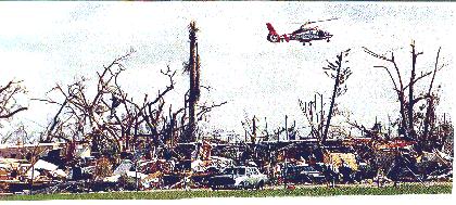
An aerial photo of a mobile home community in Homestead after Hurricane Andrew (I lived on a street that had 3 mobile home communities. This could well have been my area, because this is what it looked like across the street from my area and when you walked the streets of those trailer communities. Sheet metal lay and pierced everything in sight .. it was a constant danger when salvaging. I had several run-ins, and had to go to the medical tent for a tetanus shot).

Mobile Home Pieces in Trees- Debris from a demolished mobile home park scattered through a denuded fruit orchard along Silver Palm Drive. Mobile homes are inherently fragile and unstable in high wind, no matter how well tied down. They can be deadly not only for their occupants, but for people downwind who may be hit by their remains. Mobile homes simply should not be allowed to exist near hurricane-prone stretches of coastline

A retail store in the Cutler Ridge Mall north of Homestead

Hurricane Andrew - Boat stack storage facility destroyed by wind This structure was built with steel beams Boat damage total from Andrew approached $500 million
Some Pictures of the Aftermath (not mine)
After the Storm: Hurricane Andrew 10 years later
Today is August 24, 2005, 13 years after a terrifying and mega life-altering weather event, and the closest I've ever come to death: Hurricane Andrew. Right about now, 5:30am est, the storm was still fierce, and we were experiencing heart-stopping fear. If you lived in South Florida … and especially in deep South Dade County as I did .. it was a surreal, horrifying, disorienting and devastating storm, and one in which the seconds, minutes and hours preparing for and experiencing it .. and the days, weeks, sights, stench, months and years afterward will forever be seared in your mind and your soul.
I was working in South Miami, FL and worked late that Friday night. I lived about 10 mins. from Homestead Air Force Base in a one-story, 2-bdr. townhome in the Naranja Lakes complex. and I loved it.
I stayed up late watching the tube, and didn’t arise until about 11 a.m Saturday morning. I leisurely got some breakfast, and took it and the newspaper out to my serene lakeside deck. US#1 was just across the lake, but under my huge spreading poinciana tree and with the ducks, fish and turtles, it was a little piece of heaven and so peaceful.
Around noon, I came in and turned on CNN, and there was this huge menace out in the Atlantic .. a red ball of fury looming .. and it wasn’t that far offshore. My attitude and mode changed abruptly to more anxious.
I called one of my best friends. If anyone could be said to be as tough and fearless, it’s her. She’d had a tough life, a lot of ups and downs, and worked like a dog to make a good life for herself and her daughter. She wasn't scared of anyone or anything .. period.
When I called her that Saturday around noon and asked her if she had seen the storm, her voice was completely disquieting. She said, "Oh yeah, we're going to Orlando .. this one is BAD .. you're welcome to come with us." I was stunned nearly speechless .. of all people I expected to hear quaking about a storm. I was truly shocked .. I had an immediate attitude adjustment and total deliverance from my relaxing Saturday reverie in that second.
I said "No .. I haven't even thought about leaving .... do you really think we're gonna get it?" She was frim .. “We’re getting ready now .. I’m leaving.. this one's too big.” We hung up, and my head spun with disjointed thoughts, dizzy with the cacaphony of worry, confusion, chores and todo's darting in and out of my brain.
I realized I'd have to evacuate due to my location (there was an official evacuation order anyway by Sunday), and called my friends out in the rural Redlands and asked if I could stay with them out west from me in the grove and farmland area. As it turned out, my friend was visiting relatives for a week, but her husband said fine. So, I would clear everything that could be a dangerous missile from the front and back yards and deck, bring everything in, and then I'd take my pet bird and valuables, etc. and go.
I swung into gear, and for the rest of the day and until Sunday afternoon, I confiscated every rock, plant, tool, piece of furniture, stick, pot that could be a dangerous flying object. I had paths in my townhouse, squirreling through the mass of objects. I could barely squeeze by the ironing board filled with plants, and shimmy around the ladder and boxes of tools, etc. in my bedroom. I was going to make sure I did everything I was supposed to do.
That night, I watched half of Billy Crystal's "City Slickers" I had rented at the Blockbuster's around the corner, and then was too antsy to watch the rest. I got a few days of clothes, important papers, etc. together for my departure. The next morning, I went to church, and came back to resume my checklist of outdoor object recon, and gathered some canned goods, bird food, my portable smoker/bbq and got my bird into a travel cage. By the time I felt comfortable I had done all I could do, I packed the car. But I put off leaving as late as I could .. I was feeling dread. It was about 7pm, and a light rain was falling. On the way, I stopped by Blockbuster and put the video in the return drawer.
*********************************************************
I got out to my friends' house, a tiny 900 sq.ft. Spanish stucco house that had been moved into their 5-acre grove years earlier. Typical older S.FL Spanish-style old house: barrel tile roof, crank out windows, no screens, and deteriorated, since their new big ranch was being built about 100 yds behind this house. Sonny greeted me with their 3 dogs. He helped me unload my car, and we decided I'd park my car in the garage of the new house. Even though there were no garage doors, it was at least under cover and I was confident in the construction.
I was surprised that there were no boards up at the windows .. no preparations done to the house. Sonny is a very handy Mr. Fixit type. We got my stuff settled, had some coffee, watched TV and had the radio on with Brian Norcross, the hero and calm guide across the airwaves to the frightened thousands. My friend, his wife, called, and we talked a couple of times with her. The last call was around 4am, and things by then were really ugly . . in the middle of the call, the power and phone line were gone. We were in the pitch dark, and I took my flashlight and stuffed the bird in the guest room closet under a pile of clothes, and went back to the living room. By that time, the wind was ferocious, actually sounded like a horn section .. blowing, blaring, honking .. penetrating every crack and crevice in the window and door frames.
When they talk about a train roaring, it's true .. a vicious, deafening, menacing roar. We're were in an avocado and mango grove, and the fruit and the ceramic roof tiles on the new house were missiles, and started breaking through the back windows. That permitted the rain to blow in furiously and totally horizontally like sharp needles. We were getting soaked, and it was a cold rain.
At one point in the chaos, I saw a piece of wood about 6' long laying against the back kitchen wall, and I suggested we nail it over at least one window to block some of the incoming. Sonny's a slight man, but he's very wiry and strong. It took all the strength we both could muster to fight this force and hold up each end to nail the wood in place.
By this time, we were dripping from the rain and shivering cold, and as the fury intensified, we realized we had to move more into the middle of the house.. away from what was coming in the windows. We straddled the wall between the eating area and first bedroom, but then the bedroom windows were penetrated, and rain was spewing in there .. curtains whipping around, bedding and clothes in the closet getting soaked, door swinging wildly.
Our last refuge in this tiny house was a couple of feet in, outside the closed bathroom door in front of the linen closet door and across from the tiny guest bedroom where I would end up staying, and praying the bathroom and guestroom doors on the north and west side would hold. All 5 of us huddled there in one glob, squeezed in tight away from the flailing bedroom door, and not one sound was uttered ..for 30-40 mins., even by the 3 dogs. That’s always amazed me… that we never spoke, and the dogs never growled or barked. I never heard one peep from my parrot the whole time. We were like petrified statues ... until I heard what sounded like breathing. I told Sonny to shine his flashlight on the ceiling above us. That caused us to gasp .... the little crawl space door to the attic was heaving .. like lungs .. inhaling, exhaling.
We kept waiting for the eye .. and I decided that when the eye came, I'd grab my purse, the bird, and we'd take the dogs and run to my old car in the garage and ride it out there. Sonny became agitated .. jumping out of his skin with fear. It started to quiet down noticeably, and daylight had started dawning gray, so he'd run to the back door and look out and yell --"Ok, it's calm .. let's go." I'd grab the bird and purse and get there and see things still flying through the air. "No, .. when it's the eye, it's dead calm .. we can't go." He did that twice more, each time more antsy to get out of the house, and I had to almost slap him... he was nearly apoplectic.
Finally, things just gradually quieted more and more .. the sun was out and it was over...it was probably about 7 am. I realized afterward, that we never did get the eye. Andrew was so compact and tightly wound that the eye missed our area.
We looked out, and the new house survived, minus some of the roof tiles that had flown into our place, and thank God .. my car looked fine in the garage. Everything was soaked: the floor, carpet, carpet padding, furniture, clothes .. and we were emotionally spent, weak and really in dazed shock. I took the sofa and Sonny flopped in the guest room. The letdown from all the adrenaline was huge .. I was as limp as a dishrag .. and just collapsed in a coma-like sleep of relief.
I awoke about 4 hours later, and really got a good look at the mess inside. When Sonny woke up, we started pulling up carpet, padding, sweeping up the broken glass, and started dragging out the wet clothes to dry on the trees. Sonny started boarding up the busted back windows (which I sure wish he had done before). We talked to some neighbors and heard that miraculously there was a pay phone working at the main intersection about a mile away. I told Sonny I had to call my family. So, for the first time in my life, I hitchhiked and got a ride. The damage was everywhere and astounding. There was a line of about 20 people .. all subdued, numb.. and we all quietly waited our turn, and made a really short call so as not to keep the next person waiting.
I let my Mom know I was OK and told her to call the family and then caught a ride part way back and walked the rest. As I walked up the back stairs to the kitchen, I looked up and got the answer to the heaving lungs. From the left side of the house, about 2 ft. above the back door, was a deep fissure about 12 ft. long split into the stucco just under the roof, 3 ft. from the end of house. Had the fury lasted much longer, there's no doubt it would've finished lifting the roof off.
I don't remember much of that first night, except there was no power, there were mosquitoes, and the flashlight in bed with me.
The next day, I couldn't stand not knowing the condition of my house and was anxious to go. Sonny thought it was dangerous for me to do there alone, but I had to see it. I knew my car was fine,and I wasn't going to risk getting a flat tire with all the debris.. So, I hitchhiked with 2 guys in a truck who took me halfway there to a major intersection. I couldn't believe my eyes .. I was transported to a bizarro world. I knew this intersection like the back of my hand, and I couldn't recognize anything. The landscape had been totally rearranged. We had passed a dead horse in the road, power poles down, roads blocked and new detours made through yards and groves, greenhouse cloth hung and draped eerily between tall pines .. like sick Halloween decorations. I walked about 1/2 mi. when I saw a Dade Cty. van coming toward me. I motioned him over and asked if he'd be so kind as to drive me to my place, which he did.
When I got near my townhouse, I could see the sheet metal pieces and fragments laying everywhere and piercing everything in the area from the trailer parks across the street.
I couldn't believe my eyes: mine was the middle unit of a 7-unit lakeside bldg. The 3 units connected to mine to the east were just crumbs .. all there was left was particles of possessions of 3 homes on slabs and strewn around. Roof trusses and truss ribs were lying everywhere. There was one elderly couple in my court who never left. I was shocked they had stayed and survived at ground zero of the storm. She was sweeping water out the front door, and I asked her if she'd come in to my unit with me, 'cause I was scared to see the damage alone. She did and it was awful. So my unit was the first one with a wall standing on the east side... my INTERIOR wall. In the ensuing months, it became obvious that these units, which had been built in the early 70’s, were built with criminal negligence. The concrete I-beams weren’t even tied down to the foundations. I looked out across the lake to the shopping center .. it was decimated, along with Blockbuster .. and my dutifully returned video was among the ruins.
Reports afterward claimed that my development had the record for having the most people die in one place. Many were retired and refused to leave their “their stuff,” and the concrete beams crushed them as they crashed to the ground.

The name of the contractor was Judah Construction– and if he had been in business at the time of Hurricane Andrew, I feel fairly confident that criminal charges would’ve been brought against him, if one of the residents didn't get to him him first. The bldg. inspectors who approved this shoddy work should've been hung.
Naranja Lakes, (there had been approximately 1300 units built around 4 lakes.)

A home in Naranja Lakes in which four adults survived They took refuge in an interior closet
After Andrew, the condominium association had to be dissolved so that the master insurance policy could be redeemed to pay the owners for the value of their structures … the first time in history that was done at the time. But then since there was no association, there was no governing authority to monitor the group's actions and the alleged fraud, corruption and irregularities that occurred in the years afterward and prior to the whole property being cleared for sale in one lump parcel to a developer.

Concrete block stucco construction survived the winds - I believe this is the area where I was able to rent a room for a couple of months, until a dry and stable place was found. These homes were bunkers ..poured concrete, even the roofs and they were untouched .. and only 5 mins. from my place. They had been built in the 50's and 60's for snowbirds. This is one sure way to survive hurricanes and tornadoes in Florida.
One of my neighbors was checking his unit, and I asked him to help me kick in my office door .. something was blocking the door. He kicked it in and the back wall was without some of the concrete blocks ..open to the outside. The roof was splayed open between the roof truss ribs and there was the sky. The same in my bedroom and kitchen. All my carefully removed items from the outside were so many missiles inside instead ... and everything was strewn and soaked everywhere and dripping with white glop. Within a couple of days, we got rain, so now there was water pouring on my stuff, making life, salvaging and spirits even more raw and miserable. Good lesson: NEVER put in popcorn ceilings.
I stayed with my friends for about a month. There wasn't any FEMA, Red Cross or Salvation Army for days and days. The reports were true .. people were without water, power, food, clothes, medical care and shelter. People were genuinely at risk, and the government and emergency folks just didn't respond at all like they do now. It was August in FL, brutal temps and humidity, mosquitoes, roaches foraging in the gunk, bugs .. pure hell every day for months. They sure did learn after Andrew.
My friend's boss brought out a generator, and that made a huge difference, but we were on our own. We cleared out the canned good cupboard for meals, and rationed the generator for morning coffee and quick hot water showers. After about a week, when I was salvaging, wonderfully kind people started driving up randomly in cars or pickups out of the goodness of their hearts, with bread and food and supplies. They were angels. But no law enforcement showed up way down south in the country for well over a week, and it was awful .. so scary. Every day, my job was salvaging anything that survived. I was thankful for my disorganization when I found two boxes of family pictures intact and dry in a closet. The looting was getting more open and frightening .. people were toting guns.
It was a bad scene, and the Dade County Emergency Director, Kate Hale, finally couldn’t take it anymore, and pleaded for help:
”Three days passed between Andrew's assault and the arrival of federal help. Kate Hale, the Dade County emergency director, went on live national television on 27 August with tears in her eyes and castigated the federal government. Some of her comments were:
"Enough is enough. Quit playing like a bunch of kids. Where in the Hell is the cavalry? For God's sakes, where are they? We are going to have more casualties, because we are going to have more people dehydrated. People without water. People without food. Babies without formula. If we do not get more food into the south end of Dade County in a very short period of time, we are going to have more casualties!
We have a catastrophic disaster. We are essentially the walking wounded. We have appealed through the State to the Federal Government. We've had a lot of people down here for press conferences, but Dade County is on its own. Dade County is being caught in the middle of something and we are being victimized. Quit playing like a bunch of kids and get us aid! Sort out your political games afterward!
We are all about ready to drop, and the reinforcements are not getting in fast enough. We need better National Guard down here...President Bush was down here. I'd like him to follow up on the commitments he made.
At the time of the speech, three days after the storm, 250,000 Florida residents were struggling to survive without food, water and shelter. The nationwide uproar reached Washington DC and President Bush immediately ordered 30,000 troops to the disaster area. Lieutenant General Samuel Ebbeson (a former deputy of General Schwarzkopf during the Persian Gulf War) was placed in charge of the military relief effort.“
PSYOP IN SUPPORT OF HURRICANE ANDREW RECOVERY OPERATIONS
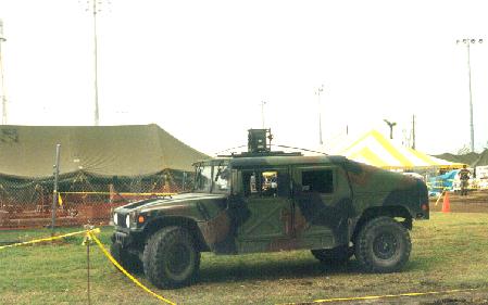
The arrival of the National Guard, the 10th Mountain Div. and the 82nd Airborne in a couple of weeks finally was a godsend. They saved us, fed us, directed traffic, supplied us with necessities, put up tent cities, instituted curfews and finally restored a semblance of order and sanity. Thank God for them ... utter chaos and anarchy had broken out, people were strained beyond their patience. Then the other service agencies arrived with more support, and the skies were soon black with news choppers and military choppers, ferrying supplies.
The aid that eventually made it down to us was incredible and was there for months and months because it was desperately needed. There were still people in FEMA trailers 18 mos. later. The generosity and help of our Florida neighbors, the awesome military troops, national and local companies, church groups, utility crews, and relief and service agencies sure was mightily appreciated.
A former Viet Nam pilot among the great military there,looking down on my neighborhood, said it was worse than Viet Nam .. and it was exactly where the bomb went off. People were in in food lines, phone lines, and mail lines from 3-5 months plus.


Hurricane Andrew - Long lines waiting for ice ration following Andrew Following major disasters, refrigeration assumes a high priority
After the streets were relatively free from debris, I felt fairly safe using my car to go to salvage .. which I did for about 6 months, helping friends as well.. that was my daily job. I still got flat tires anyway. What was so very disorienting and upsetting for months was having all the anchors in my life .. my things .. my red dress, favorite earrings, hair curlers, serving dishes, a certain necklace .. everything that was part of my life .. strewn, buried, hard to find and away from me and subject to theft … it’s was agonizing. It sounds silly and I do believe that life and people come before things, but the order of your things and knowledge of where they are and their safety had more impact and affect than I ever knew.
What happened in the next 6-12 months made living there intolerable for me. All the construction people, opportunists, addicts and wackos made a beeline for the area for the insurance and rebuilding $$, along with the decent and earnest workers, but there were no places to live. They made pup tent communes or lived like nomads, bathing in canals, urinating in public, hanging around at the one open supermarket that was able to open, when they weren't working, and collecting daily pay when they did. Then at night, they'd spend it all at the bar or on drugs and menace the neighborhoods. 3 times, there were drunks unconscious in the backyard. The last straw was a 4am knock on the door by a gun-toting creature looking for a cigarette. He was also met with a gun, and walked away but shot at the roof as he left.
I relocated to the west coast almost 2 years after Andrew to start all over again..I couldn't take the crime and living like a prisoner any longer, and the west coast had been fairly untouched. The experience left me with terrible anxiety attacks that lasted for years. It was 6 months before I could drive alone again without panic attacks, and I had loved driving before Andrew .. never gave it a thought. To this day, I cannot stand high winds .. I become unglued .. very pacey and agitated .. there definitely is PTSS. In the traumatic days and months, little moments during the storm time were forgotten until years later, popping into my head like one of those turtles that swam in my lake.
After Andrew, the whole South Dade area took on a wild west and tense atmosphere, and the complexion, landscape and mood of the area changed drastically.
One of the saddest things was the people you'd see regularly at the cleaners or the gas station or hardware store were just gone. You didn't know them by name, they were just fixtures and familiar faces in your life .. and they were gone .. to places unknown .. never to be seen by you again or know what happened to them.
All those who decided to stay right after were frustrated, depressed and weary, and there was gobs of insurance and emergency funds floating around and an abundance of vultures all too willing to victimize very vulnerable people and compound the misery. BTW, the worst name you could call someone was “roofer” ... that was a curse word.
The sights and mostly the stench .. they just wore you down, and then dealing with paperwork and bureaucracies ..life just got depressing and infurating at times, and tempers got very short. Deep South Dade was a beautifully lush, botanical paradise .. palms, tall pines and oaks .. and those were just bent or cut down to ugly sticks or just gone. The countryside looked sad .. just pitiful, and it brought you down more. There were increased divorces and suicides afterward .. the stress just tore people and couples apart.
My unit was robbed ultimately. I had left some serving pieces and small appliances in my undamaged utility room. There were locked steel security doors and windows on my unit, but someone actually got in through a hole in the roof and had passed items down to someone out front on the grass before they got scared off, which I found when I arrived to get some platters for Thanksgiving dinner. After all the hell, that just broke my heart...as trivial as it was, in light of everything else .. it was an invasion I bitterly resented.
 The Holiday Inn along the Turnpike in south Dade County. Almost every window, and a few doors, were blown out; and much of the main roof sign was gone. It took two direct eyewall hits sandwiched around a short period inside the northern part of the eye -- and remained largely intact. Despite the ugly superficial damage, this steel-reinforced concrete edifice stayed structurally sound, and soon reopened for business.

Royal palm impaled by a 1X4 board just north of Homestead, looking N. This was near the inner edge of the eyewall. The board was somehow aligned almost perfectly in 120+ kt flow, with the vertical axis of the palm, and at exactly the right time, to cause this oddity. Another view of the same thing is shown in (I saw several penetrated trees like this)
*******************************
"The damage survey showed the peak winds in both the front and back eyewalls to be at nearly right angles to the circular isobars. Thus a transient associated with convection that might cause increased inflow into the convective cells would cause the air to cool and parcels to be forced downward in much the same manner as a down burst, which would enhance the inward acceleration.
It is thus hypothesized that periodic surges of surface super-gradient flow penetrated into the clear eye producing several momentary wind transients, the strongest of which occurred over Naranja Lakes. These periodic transients appear to be associated with eyewall supercell convection that was triggered at the coast by enhance frictional convergence as the eyewall moved across the shoreline. Analysis of the Tampa radar data showed that 7 convective cells were triggered at the coast line about every 12 minutes and lasted about 10 minutes as they traveled around the eyewall, reaching peak reflectivities in the southwest quadrant. Each eyewall cell appears to have a had a wind transient associated with it, with the one passing over Naranja Lakes being the strongest."
*******************************************************
I'm so grateful to God we survived .. I know several people who ended up in their bathtub under a mattress, with nothing but sky above. I've never returned to S. FL, after living there for over 25 years, though I've been invited back for visits with friends, and have no desire to go back .. too many scars and nauseating memories. Dealing with last year's hurricanes on the west coast, lying in the dark under a mattress in the hallway, listening to the wind's fury overhead and praying the roof would hold .. well, that finally put the final nail in the coffin of living in Florida for me. "Get out" were the words reverberating in my head non-stop for days .. like Morse code from God, and I was out of there and on my way north in a month. I'll be dealing with winter, snow and bitter cold, something I'd sworn for years I'd never do again, but I will now gladly deal with that over hurricanes anytime. It’s been enough for 3 lifetimes. I now say that God is the director, and I'm just trying to learn my lines.
I'm sure those who suffered through Ivan, Charley, Jeanne and Frances experienced the same emotional ups and downs and physical strain of it all as I did with Andrew. Thankfully, the lesson was learned with Andrew about getting aid and supplies in quickly in such disasters. I don't think there will be the extreme suffering and crime that we experienced in future disasters. I pray there won't be.
There's so much I didn't find out about that time for years later, you just stay in a state of shock, without electricity for months, and you're totally shut off from the world outside, and even what's happening in the next town. You're focused on necessities and the next task at hand for months and months. There's much I still don't know about that time that I keep learning. I'm wondering how many other FReepers there are who survived Andrew in South Dade .. I hope you'll chime in. I'll never forget it nor that God is good. I get involuntary internal jitters every time a new storm starts brewing in the Atlantic or Gulf, and I have so much empathy for the folks dealing with the current volatile hurricane season, and pray these monsters just stay away. I don't say never anymore ... at least not with much conviction.
Hard to believe it's been 13 years. You have pulled together lots of interesting info here.
BTW Andrew was a catergory 4 when it hit. Still, it was one for the record books.
The NHC upgraded Andrew to Cat 5 at landfall several years ago, based on re-examination of data and damage.
http://www.nhc.noaa.gov/1992andrew.html
Andrew was a small and ferocious Cape Verde hurricane that wrought unprecedented economic devastation along a path through the northwestern Bahamas, the southern Florida peninsula, and south-central Louisiana. Damage in the United States is estimated to be near 25 billion, making Andrew the most expensive natural disaster in U.S. history1. The tropical cyclone struck southern Dade County, Florida, especially hard, with violent winds and storm surges characteristic of a category 4 hurricane on the Saffir/Simpson Hurricane Scale, and with a central pressure (922 mb) that is the third lowest this century for a hurricane at landfall in the United States. In Dade County alone, the forces of Andrew resulted in 15 deaths and up to one-quarter million people left temporarily homeless. An additional 25 lives were lost in Dade County from the indirect effects of Andrew2. The direct loss of life seems remarkably low considering the destruction caused by this hurricane.
a. Synoptic History
Satellite pictures and upper-air data indicate that Hurricane Andrew formed from a tropical wave that crossed from the west coast of Africa to the tropical North Atlantic Ocean on 14 August 1992. The wave moved westward at about 20 kt, steered by a swift and deep easterly current on the south side of an area of high pressure. The wave passed to the south of the Cape Verde Islands on the following day. At that point, meteorologists at the National Hurricane Center (NHC) Tropical Satellite Analysis and Forecast (TSAF) unit and the Synoptic Analysis Branch (SAB) of the National Environmental Satellite Data and Information Service (NESDIS) found the wave sufficiently well-organized to begin classifying the intensity of the system using the Dvorak (1984) analysis technique.
Convection subsequently became more focused in a region of cyclonic cloud rotation. Narrow spiral-shaped bands of clouds developed around the center of rotation on 16 August. At 1800 UTC on the 16th (UTC precedes EDT by four hours), both the TSAF unit and SAB calculated a Dvorak T-number of 2.0 and the "best track" (Table 1 and Fig. 1 [85K GIF]) shows that the transition from tropical wave to tropical depression took place at that time.
The depression was initially embedded in an environment of easterly vertical wind shear. By midday on the 17th, however, the shear diminished. The depression grew stronger and, at 1200 UTC 17 August, it became Andrew, the first Atlantic tropical storm of the 1992 hurricane season. The tropical cyclone continued moving rapidly on a heading which turned from west to west-northwest. This course was in the general direction of the Lesser Antilles.
Between the 17th and 20th of August, the tropical storm passed south of the center of the high pressure area over the eastern Atlantic. Steering currents carried Andrew closer to a strong upper-level low pressure system centered about 500 n mi to the east-southeast of Bermuda and to a trough that extended southward from the low for a few hundred miles. These currents gradually changed and Andrew decelerated on a course which became northwesterly. This change in heading spared the Lesser Antilles from an encounter with Andrew. The change in track also brought the tropical storm into an environment of strong southwesterly vertical wind shear and quite high surface pressures to its north. Although the estimated maximum wind speed of Andrew varied little then, a rather remarkable evolution occurred.
Satellite images suggest that Andrew produced deep convection only sporadically for several days, mainly in several bursts of about 12 hours duration. Also, the deep convection did not persist. Instead, it was stripped away from the low-level circulation by the strong southwesterly flow at upper levels. Air Force Reserve unit reconnaissance aircraft investigated Andrew and, on the 20th, found that the cyclone had degenerated to the extent that only a diffuse low-level circulation center remained. Andrew's central pressure rose considerably (Fig. 2 [87K GIF]). Nevertheless, the flight-level data indicated that Andrew retained a vigorous circulation aloft. Wind speeds near 70 kt were measured at an altitude of 1500 ft near a convective band lying to the northeast of the low-level center. Hence, Andrew is estimated on 20 August to have been a tropical storm with 40 kt surface winds and an astonishingly high central pressure of 1015 mb (Figs. 2 and 3 [87K GIF]).
Significant changes in the large-scale environment near and downstream from Andrew began by 21 August. Satellite imagery in the water vapor channel indicated that the low aloft to the east-southeast of Bermuda weakened and split. The bulk of the low opened into a trough which retreated northward. That evolution decreased the vertical wind shear over Andrew. The remainder of the low dropped southward to a position just southwest of Andrew where its circulation enhanced the upper-level outflow over the tropical storm. At the same time, a strong and deep high pressure cell formed near the U.S. southeast coast. A ridge built eastward from the high into the southwestern Atlantic with its axis lying just north of Andrew. The associated steering flow over the tropical storm became easterly. Andrew turned toward the west, accelerated to near 16 kt, and quickly intensified.
Andrew reached hurricane strength on the morning of 22 August, thereby becoming the first Atlantic hurricane to form from a tropical wave in nearly two years. An eye formed that morning and the rate of strengthening increased. Just 36 hours later, Andrew reached the borderline between a category 4 and 5 hurricane and was at its peak intensity (Table 1). From 0000 UTC on the 21st (when Andrew had a barely perceptible low-level center) to 1800 UTC on the 23rd the central pressure had fallen by 92 mb, down to 922 mb. A fall of 72 mb occurred during the last 36 hours of that period and qualifies as rapid deepening (Holliday and Thompson, 1979).
The region of high pressure held steady and drove Andrew nearly due west for two and a half days beginning on the 22nd. Andrew was a category 4 hurricane when its eye passed over northern Eleuthera Island in the Bahamas late on the 23rd and then over the southern Berry Islands in the Bahamas early on the 24th. After leaving the Bahamas, Andrew continued moving westward toward southeast Florida.
Andrew weakened when it passed over the western portion of the Great Bahama Bank and the pressure rose to 941 mb. However, the hurricane rapidly reintensified during the last few hours preceding landfall when it moved over the Straits of Florida. During that period, radar, aircraft and satellite data showed a decreasing eye diameter and strengthening "eyewall" convection. Aircraft and inland surface data Fig. 4 [121K GIF]) suggest that the deepening trend continued up to and slightly inland of the coast. For example, the eye temperature measured by the reconnaissance aircraft was at least 1-2C warmer at 1010 UTC (an hour after the eye made landfall) than it was in the last "fix" about 15 n mi offshore at 0804 UTC. These measurements suggest that the convection in the eyewall, and the associated vertical circulation in the eye and eyewall, became more vigorous as the storm moved onshore. The radar data indicated that the convection in the northern eyewall became enhanced with some strong convective elements rotating around the eyewall in a counter-clockwise fashion as the storm made landfall. Numerical models suggest that some enhancement of convection can occur at landfall due to increased boundary-layer convergence in the eyewall region. That situation appeared to have occurred in Andrew. The enhanced convection in the north eyewall probably resulted in strong subsidence in the eye on the inside edge of the north eyewall. This likely contributed to a displacement of the lowest surface pressure to the north of the geometric center of the "radar eye" (cf., Fig. 4 and 6 [107K JPEG]). It is estimated that the central pressure was 922 mb at landfall near Homestead AFB, Florida at 0905 UTC (5:05 A.M. EDT) 24 August (Fig. 4).
The maximum sustained surface wind speed (1-min average at 10 meters [about 33 ft] elevation) during landfall over Florida is estimated at 125 kt (about 145 mph), with gusts at that elevation to at least 150 kt (about 175 mph). The sustained wind speed corresponds to a category 4 hurricane on the Saffir/Simpson Hurricane Scale. It should be noted that these wind speeds are what is estimated to have occurred within the (primarily northern) eyewall in an open environment such as at an airport, at the standard 10-meter height. The wind experienced at other inland sites was subject to complex interactions of the airflow with trees, buildings, and other obstacles in its path. These obstructions create a turbulent, frictional drag that generally reduces the wind speed. However, they can also produce brief, local accelerations of the wind immediately adjacent to the structures. Hence, the wind speed experienced at a given location, such as at a house in the core region of the hurricane, can vary significantly around the structure, and cannot be specified with certainty. The landfall intensity is discussed further in Section b.
Andrew moved nearly due westward when over land and crossed the extreme southern portion of the Florida peninsula in about four hours. Although the hurricane weakened about one category on the Saffir/Simpson Hurricane Scale during the transit over land, and the pressure rose to about 950 mb, Andrew was still a major hurricane when its eyewall passed over the extreme southwestern Florida coast.
The first of two cycles of modest intensification commenced when the eye reached the Gulf of Mexico. Also, the hurricane continued to move at a relatively fast pace while its track gradually turned toward the west-northwest.
When Andrew reached the north-central Gulf of Mexico, the high pressure system to its northeast weakened and a strong mid-latitude trough approached the area from the northwest. Steering currents began to change. Andrew turned toward the northwest and its forward speed decreased to about 8 kt. The hurricane struck a sparsely populated section of the south-central Louisiana coast with category 3 intensity at about 0830 UTC on the 26th. The landfall location is about 20 n mi west-southwest of Morgan City.
Andrew weakened rapidly after landfall, to tropical storm strength in about 10 hours and to depression status 12 hours later. During this weakening phase, the cyclone moved northward and then accelerated northeastward. Andrew and its remnants continued to produce heavy rain that locally exceeded 10 inches near its track (Table 2b). By midday on the 28th, Andrew had begun to merge with a frontal system over the mid-Atlantic states.
b. Meteorological Statistics
The best track intensities were obtained from the data presented in Figs. 2, 3, 4, and 5 (95K GIF). The first two of those figures show the curves of Andrew's central pressure and maximum sustained one-minute wind speed, respectively, versus time, along with the observations on which they were based. The figures contain relevant surface observations and intensity estimates derived from analyses of satellite images performed by the TSAF unit, SAB and the Air Force Global Weather Central (USAF in figures). The aircraft data came from reconnaissance flights by the U.S. Air Force Reserve 815th Weather Reconnaissance Squadron based at Keesler AFB, Mississippi. Additional data were collected aboard a NOAA aircraft.
Table 2 lists a selection of surface observations. The anemometer at Harbour Island, near the northern end of Eleuthera Island in the Bahamas, measured a wind speed of 120 kt for an unknown period shortly after 2100 UTC on the 23rd. That wind speed was the maximum that could be registered by the instrument.
Neither of the two conventional measures of hurricane intensity, central barometric pressure and maximum sustained wind speed, were observed at official surface weather stations in close proximity to Andrew at landfall in Florida. Homestead Air Force Base and Tamiami Airport discontinued routine meteorological observations prior to receiving direct hits from the hurricane. Miami International Airport was the next closest station, but it was outside of the eyewall by about 5 nautical miles when Andrew's center passed to the south of that airport.
To supplement the official information, requests for data were made to the public through the local media. Remarkably, more than 100 quantitative observations were received (see Figs. 4 and 5). Many of the reports came from observers who vigilantly took readings through frightening conditions including, in several instances, the moment when their instruments and even their homes were destroyed.
Some of the unofficial observations were dismissed as unrealistic. Others were rendered suspect or eliminated during follow-up inquiries or analyses. The remainder, however, revealed a physically consistent and reasonable pattern.
1. Minimum pressure over Florida
The final offshore "fix" by the reconnaissance aircraft came at 0804 UTC and placed the center of the hurricane only about 15 nautical miles, or roughly one hour of travel time, from the mainland. A dropsonde indicated a pressure of 932 mb at that time. The pressure had been falling at the rate of about 2 mb per hour, but the increasing interaction with land was expected to at least partially offset, if not reverse, that trend. Hence, a landfall pressure within a few millibars of 932 mb seemed reasonable.
Shortly after Andrew's passage, however, reports of minimum pressures below 930 mb were received from the vicinity of Homestead, Florida (Fig. 4). Several of the barometers displaying the lowest pressures were subsequently tested in a pressure chamber and calibrated by the Aircraft Operations Center (AOC) of NOAA. Two key observations came from a Mrs. Hall and Mr. Martens, sister and brother. They rode out the storm in residences about one-quarter mile apart. Mrs. Hall's home was built by her father and grandfather in 1945 to be hurricane-proof. Although some of the windows broke, the 22-inch thick concrete and coral rock walls held steady, allowing her to observe her barometer in relative safety. The AOC tests indicate that the minimum pressure at her home was near 921 mb. The barometer at her brother's home was judged a little more reliable and the reading there was adjusted to 923 mb. Based on the observations and an eastward extrapolation of the pressure pattern to the coastline, Andrew's minimum pressure at landfall is estimated to be 922 mb. This suggests that the trajectory of the dropsonde deployed from the aircraft did not intersect the lowest pressure within the eye.
In the United States, this century, only the Labor Day (Keys') Storm in 1935 [103K GIF] (892 mb) and Hurricane Camille in 1969 [122K GIF] (909 mb) had lower landfall central pressures than Andrew (Hebert et al. 1992).
2. Maximum wind speed over Florida
The strongest winds associated with Andrew on 24 August likely occurred in the hurricane's northern eyewall. The relatively limited number of observations in that area greatly complicates the task of establishing Andrew's maximum sustained wind speed and peak gust at landfall in Florida. While a universally accepted value for Andrew's wind speed at landfall may prove elusive, there is considerable evidence supporting an estimate of about 125 kt for the maximum sustained wind speed, with gusts to at least 150 kt (Fig. 5).
The strongest reported sustained wind near the surface occurred at the Fowey Rocks weather station at 0800 UTC (Fig. 5). The station sits about 11 n mi east of the shoreline and, at that time, was within the northwest part of Andrew's eyewall. The 0800 UTC data included a two-minute wind of 123 kt with a gust to 147 kt at a platform height of about 130 ft. The U.S. National Data Buoy Center used a boundary-layer model to convert the sustained wind to a two-minute wind of 108 kt at 33 ft elevation. The peak one-minute wind during that two-minute period at Fowey Rocks might have been slightly higher than 108 kt.
It is unlikely that this point observation was so fortuitously situated that it represents a sampling of the absolute strongest wind. The Fowey Rocks log (not shown) indicates that the wind speed increased through 0800 UTC. Unfortunately, Fowey Rocks then ceased transmitting data, presumably because even stronger winds disabled the instrumentation. (A subsequent visual inspection indicated that the mast supporting the anemometer had become bent 90 degrees from vertical.) Radar reflectivity data suggests that the most intense portion of Andrew's eyewall had not reached Fowey Rocks by 0800 UTC and that the wind speed could have continued to increase there for another 15 to 30 minutes. A similar conclusion can be reached from the pressure analysis in Fig. 4 which indicates that the pressure at Fowey Rocks probably fell by about another 20 mb from the 0800 UTC mark of 968 mb.
Reconnaissance aircraft provided wind data at a flight level of about 10,000 ft. The maximum wind speed along 10 seconds of flight track (often used by the NHC to represent a one-minute wind speed at flight level) on the last pass prior to landfall was 162 kt, with a spot wind speed of 170 kt observed. The 162 kt wind occurred at 0810 UTC in the eyewall region about 10 n mi to the north of the center of the eye. Like the observation from Fowey Rocks, the aircraft provided a series of "point" observations (i.e., no lateral extent). Somewhat higher wind speeds probably occurred elsewhere in the northern eyewall, a little to the left and/or to the right of the flight track. A wind speed at 10,000 ft is usually reduced to obtain a surface wind estimate. Based on past operational procedures, the 162 kt flight-level wind is compatible with maximum sustained surface winds of 125 kt.
One of the most important wind speed reports came from Tamiami Airport, located about 9 n mi west of the shoreline. As mentioned earlier, routine weather observations ended at the airport before the full force of Andrew's (northern) eyewall winds arrived. However, the official weather observer there, Mr. Scott Morrison, remained on-station and continued to watch the wind speed dial. Mr. Morrison notes that around 0845 UTC (0445 EDT) the wind speed indicator "pegged" at a position a little beyond the dial's highest marking of 100 kt, at a point that he estimates corresponds to about 110 kt. (Subsequent tests of the wind speed dials observed at the airport indicate that the needles peg at about 105 kt and 108 kt, respectively). He recounts that the needle was essentially fixed at that spot for three to five minutes, and then fell back to 0 when the anemometer failed. Mr. Morrison's observations have been closely corroborated by two other people. He has also noted that the weather conditions deteriorated even further after that time and were at their worst about 30 minutes later. This information suggests that, in all likelihood, the maximum sustained wind speed at Tamiami Airport significantly exceeded 105 kt.
A number of the wind speeds reported by the public could not be substantiated and are therefore excluded from Fig. 5. The reliability of some of the others suffer from problems that include non-standard averaging periods and instrument exposures, and equipment failures prior to the arrival of the strongest winds.
The only measurement of a sustained wind in the southern eyewall came from an anemometer on the mast of an anchored sailboat (see Fig. 5). For at least 13 minutes the anemometer there showed 99 kt, which was the maximum that the readout could display. A small downward adjustment of the speed should probably be applied because the instrument was sitting 17 m above the surface rather than at the standard height of 10 m. On the other hand, the highest one-minute wind speed during that 13-minute period could have been quite a bit stronger than 99 kt. Again, there may have been stronger winds elsewhere in the southern eyewall. For a westward-moving hurricane the wind speed in the northern eyewall usually exceeds the wind speed in the southern eyewall by about twice the forward speed of the hurricane (Dunn and Miller 1964). In the case of Andrew, that difference is about 32 kt, and suggests a maximum sustained wind stronger than 130 kt.
Several indirect measures of the sustained wind speed are of interest. First, a standard empirical relationship between central pressure and wind speed (Kraft 1961) applied to 922 mb yields around 135 kt. Second, the Dvorak technique classification performed by the NHC Tropical Satellite Analysis and Forecast unit using a 0900 UTC satellite image gives 127 kt. Also, an analysis of the pressure pattern in Fig. 4 gives a maximum gradient wind of around 140 kt.
The strongest gust reported from near the surface occurred in the northern eyewall a little more than a mile from the shoreline at the home of Mr. Randy Fairbank. He observed a gust of 184 kt moments before portions of a windward wall failed, preventing further observation. The hurricane also destroyed the anemometer. To evaluate the accuracy of the instrument, three anemometers of the type used by Mr. Fairbank were tested in a wind tunnel at Virginia Polytechnic Institute and State University. Although the turbulent nature of the hurricane winds could not be replicated, the results of the wind tunnel tests suggest that the gust Mr. Fairbank observed was less than 184 kt and probably near 154 kt. Of course, stronger gusts may have occurred there at a later time, or at another site. Damage at that location was significantly less than the damage to similar structures located about 2 miles south of this neighborhood, implying even stronger winds than observed at this location.
Strong winds also occurred outside of the eyewall, especially in association with convective bands (Fig. 6). A peak gust to 139 kt was observed at a home near the northern end of Dade County (Fig. 5) on an anemometer of the brand used by Mr. Fairbank. Applying the reduction suggested by the wind tunnel tests to 139 kt yields an estimate close to the 115 kt peak gust (a five-second average) registered on a National Ocean Survey anemometer located not far to the east, at the coast.
3. Storm surge
During the afternoon of 23 August, Andrew crossed over the north end of the island of Eleuthera in the Bahamas and generated significant storm surge flooding. Two high water marks were recorded and referenced to mean sea level. The first mark of 16 ft was recorded in a house in the town of Little Bogue. The second mark of 23 ft was recorded in a damaged house in the town of The Current several miles west of Lower Bogue. Since this structure was located near the shoreline it suggests that battering waves riding on top of the storm surge helped to create this very high water mark.
During the morning hour of 24 August, Andrew generated storm surge along shorelines of southern Florida (Fig. 7) (103K GIF). On the southeast Florida coast, peak storm surge arrived near the time of high astronomical tide. The height of the storm tide (the sum of the storm surge and astronomical tide, referenced to mean sea level) ranged from 4 to 6 ft in northern Biscayne bay increasing to a maximum value of 16.9 ft at the Burger King International Headquarters, located on the western shoreline in the center of the bay, and decreasing to 4 to 5 ft in southern Biscayne Bay. The observed storm tide values on the Florida southwest coast ranged from 4 to 5 ft near Flamingo to 6 to 7 ft near Goodland.
Storm tides in Louisiana were at least 8 ft (Table 2a) and caused flooding from Lake Borgne westward through Vermillion Bay.
4. Tornadoes
There have been no confirmed reports of tornadoes associated with Andrew over the Bahamas or Florida. Funnel sightings, some unconfirmed, were reported in the Florida counties of Glades, Collier and Highlands, where Andrew crossed in daylight. In Louisiana, one tornado occurred in the city of Laplace several hours prior to Andrew's landfall. That tornado killed 2 people and injured 32 others. Tornadoes in the Ascension, Iberville, Baton Rouge, Pointe Coupee, and Avoyelles parishes of Louisiana reportedly did not result in casualties. Numerous reports of funnel clouds were received by officials in Mississippi and tornadoes were suspected to have caused damage in several Mississippi counties. In Alabama, the occurrence of two damaging tornadoes has been confirmed over the mainland while another tornado may have hit Dauphin Island. As Andrew and its remnants moved northeastward over the eastern states, it continued to produce severe weather. For example, several damaging tornadoes in Georgia late on 27 August were attributed to Andrew.
5. Rainfall
Andrew dropped sufficient rain to cause local floods even though the hurricane was relatively small and generally moved rather fast. Rainfall totals in excess of seven inches were recorded in southeast Florida, Louisiana, and Mississippi (Table 2b). Rainfall amounts near five inches occurred in several neighboring states. Hammond, Louisiana reported the highest total, 11.92 inches.
c. Casualty and Damage Statistics
Table 3 lists a count of casualties and damages associated with Andrew. The number of deaths directly attributed to Andrew is 26. The additional indirect loss of life brought the death toll to 65 (see footnote 2). A combination of good hurricane preparedness and evacuation programs likely helped minimize the loss of life. Nevertheless, the fact that no lives were lost in the United States due to storm surge is viewed as a fortunate aberration.
Table 3a reveals that more than one-half of the fatalities were indirect. Many of the indirect deaths occurred during the "recovery phase" following Andrew's passage.
Damage is estimated at $25 billion. Andrew's impact on southern Dade County, Florida was extreme from the Kendall district southward through Homestead and Florida City, to near Key Largo (Table 3b). Andrew reportedly destroyed 25,524 homes and damaged 101,241 others. The Dade County Grand Jury reported that ninety percent of all mobile homes in south Dade County were totally destroyed. In Homestead, more than 99% (1167 of 1176) of all mobile homes were completely destroyed. The Miami Herald reported $0.5 billion in losses to boats in southeast Florida.
The most devasted areas correspond closely in location to the regions overspread by Andrew's eyewall and its accompanying core of destructive winds and, near the coastline, decimating storm surges. Flight-level data about an hour prior to landfall places the radius of maximum wind at 11 n mi (in the northern eyewall at 10,000 ft altitude). The radius of maximum wind at the surface was likely a little less than 11 n mi. (Figure 6) displays a radar reflectivity pattern (similar to rainfall intensity) about 30 minutes prior to landfall, superimposed on a map of southern Florida, from which it can be seen that the average diameter of the "radar" eye was about 11 n mi at landfall.)
The damage to Louisiana is estimated at $1 billion.
Damage in the Bahamas has been estimated at $0.25 billion.
Andrew whipped up powerful seas which extensively damaged many offshore structures, including the artificial reef system of southeast Florida. For example, the Belzona Barge is a 215 ft, 350-ton barge that, prior to Andrew, was sitting in 68 ft of water on the ocean floor. One thousand tons of concrete from the old Card Sound bridge lay on the deck. The hurricane moved the barge 700 ft to the west (50-100 tons of concrete remain on deck) and removed several large sections of steel plate sidings.
Damage in the Gulf of Mexico is preliminarily estimated at $0.5 billion. Ocean Oil reported the following in the Gulf of Mexico: 13 toppled platforms, five leaning platforms, 21 toppled satellites, 23 leaning satellites, 104 incidents of structural damage, seven incidents of pollution, two fires, and five drilling wells blown off location.
Hurricanes are notoriously capricious. Andrew was a compact system. A little larger system, or one making landfall just a few nautical miles further to the north, would have been catastrophic for heavily populated, highly commercialized and no less vulnerable areas to the north. That area includes downtown Miami, Miami Beach, Key Biscayne and Fort Lauderdale. Andrew also left the highly vulnerable New Orleans region relatively unscathed.
d. Forecast and Warning Critique
Track forecast errors by the NHC and by the suite of track prediction models are given in Table 4. On average, the NHC errors were about 30% smaller than the current 10-year average. The most significant changes in Andrew's track and intensity (see Fig. 1, Table 1) were generally well anticipated (noted in NHC's Tropical Cyclone Discussions) and the forecast tracks generally lie close to the best track. However, the rate of Andrew's westward acceleration over the southwestern Atlantic was greater than initially forecast. In addition, the NHC forecast a rate of strengthening that was less than what occurred during Andrew's period of rapid deepening.
Several of the dynamic track models had stellar performances during this hurricane. The Aviation Model and a tracking routine that follows a simulated hurricane vortex (AVNO) performed especially well. However, this was the first storm for which AVNO output was available to NHC forecasters. Hence, its operational reliability was not established. The GFDL and QLM models also had small errors. It should be pointed out, however, that the NHC works on a six-hourly forecast cycle and that the models mentioned above are run just once per 12 hours. Moreover, the output from these models becomes available to forecasters no earlier than the following six-hour forecast cycle.
Historically, the NHC90 statistical-dynamical model has been the most accurate of NHC's track guidance models. The NHC90 errors were rather large during Andrew. Because the NHC90 uses output from the Aviation Model it is possible that the recent changes in the latter model may be responsible for the NHC90's degraded performance.
Table 5 lists a chronology of watches and warnings issued by the National Hurricane Center and the Government of the Bahamas. The associated lead times (based on landfall of the eye) are given in Table 6.
Massive evacuations were ordered in Florida and Louisiana as the likelihood of Andrew making landfall in those regions increased (Table 7). About 55,000 people left the Florida Keys. Evacuations were ordered for 517,000 people in Dade County, 300,000 in Broward County, 315,000 in Palm Beach County and 15,000 in St. Lucie County. For counties further west in Florida, evacuation totals exceeding one thousand people are Collier (25,000), Glades (4,000) and Lee (2,500).
It is estimated that 1,250,000 people evacuated from parishes in southeastern and south-central Louisiana.
About 250,000 people evacuated from Orange and Jefferson Counties in Texas.
The winds in Hurricane Andrew wreaked tremendous structural damage, particularly in southern Dade County. Notwithstanding, the loss of life in Hurricane Andrew, while very unfortunate, was far less than has previously occurred in hurricanes of comparable strength. Historical data suggests that storm surge is the greatest threat to life. Some lives were likely saved by the evacuation along the coastline of southeast Florida. The relatively small loss of life there serves as testimony to the success and importance of coordinated programs of hurricane preparedness.
Sorry, I stand corrected then.
Ping to my Andrew thread.
Ahh, sweet memories....of the most fearful night of my life!
Ditto! Where were you?
Perrine...right off of 152d street (plan called Mangowood).
I remember that area .. did you lose your home? I hope not.
I lived in Doral (west of Miami Airport) from 1999-2002. Never thankfully had to experience a hurricane like Andrew, although my nabe was turned into a lake by Irene, and several "tropical storms" while I lived there. It was kind of odd haveing to walk to my car wearing knee-high waterproof boots in order to get to work on occassion.
South of the Falls Mall has always been a "no mans land" to me. When I lived there, I very rarely ventured north of Hialeah or south of Dadeland.
The demographics of Homestead changed dramatically after Andrew .. and I think, now that they have the NASCAR track there, it's just starting to regenerate and come back strong. My friends tell me the place is booming with new developments and shopping centers. Problem: most of the development seems to be EAST of US l.
Did you ever hear about the trucks full of bodies?
What's amazed me in addition to the creeping suburban sprawl in southern Dade County has been the building of million dollar condos on Biscayne Boulevard, aka Hooker heaven.
Still had walls..but every window was blown in (including 6 sliding glass windows in the back of the house) and we lost some of the roof. Moved to Key West four months after Andrew.
LOL...I hated to go North of Dadeland. Spent most of my time between Cutler Ridge and Key Biscane.
Yep, as well as the AIDS infected monkeys that were on the loose. In all seriousness, there were (non-infected) monkeys who did escape from Monkey Jungle. Even better were the tropical birds who escaped from Parrot Jungle and can still be seen flying around town.
Disclaimer: Opinions posted on Free Republic are those of the individual posters and do not necessarily represent the opinion of Free Republic or its management. All materials posted herein are protected by copyright law and the exemption for fair use of copyrighted works.