The shot on the right is rather amazing.
If they haven't been excavated or even physically explored, how does the writer know these are "ceremonial sites"?
Didn’t know the Mayans had computers. Learn something new every day
I like the one where an acedemic decides to try to locate an item he believes is the staff of Moses. He works from his office chasing this thing all around the world...and when he finally tracks it down it is in a museum literally across the street from where he’d been working.

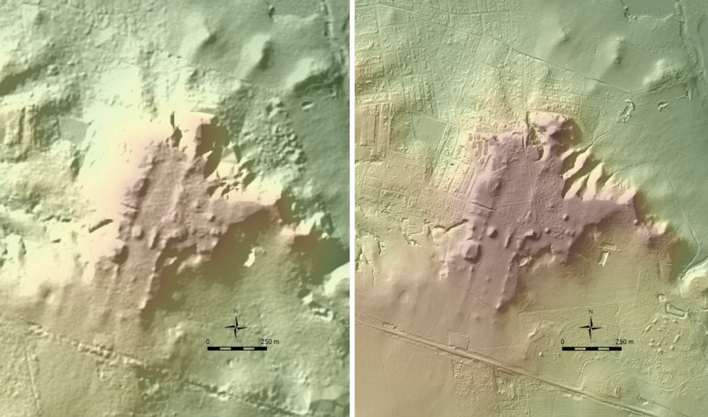
Map of the city of Tikal, in northern Guatemala, which has been restored over the course of a century.

Picture of Temple I and Temple II (see map)
The "gravestone" like objects are "stele", which have carved images and text written by the Maya. To create a hard, flat surface on which to build their temples, they created a concrete slab of ground limestone. In Tikal, they had also built large artificial lakes, lined with this limestone concrete. 
He’d better not try to use that as a source on Wikipedia. Maps apparently ain’t kosher, nor is “original research.” What a joke.
Among many others here is one my best finds so far, it is of an undocumented Pueblo in North America hidden in plain sight next to a known Pueblo. I'm sure the local indigenous elders know about it, but I have yet to find any reference or documentation for it.

But when discussing South America the sheer amount of land that was once cultivated is just incredible, much of it very remote and in places that are almost inaccessible. There are faint remains of cultivated land all over South America to the point that it greatly argues against the current population estimates. I am figuring by about four times more from what I have archived over the years. And there are of course obvious traces. But what I have estimated myself in this search is that there had to have been an incredible population to require this sheer amount of acreage, it is in the millions of total acres. Some examples of very faint remains and some of more obvious remains all in places very remote and impractical by today's standards. These would have only come about because of sheer necessity for more production and increased population because of where they are located, they were running out of room and had to expand into areas that were very impractical.


Give a Mayan a computer and there's no telling what he can do.
Nat Geo did a special that included this guy, unless I am mistaken.
Apparently this is ~ artnet.com ~ stumbling into the 21st century. These LIDAR imaging studies have been on TV repeatedly the past six or seven years.
I am anxious to see LIDAR scans of the Andes north and east of Cuzco, Peru. LIDAR technology can penetrate the foliage cover in the mountainous area and intersect dangerous exploration expeditions. Inca roads could emerge and perhaps large pre-Spanish settlements ... settlements perhaps similar to Machu Picchu.

“Rustic” Incan {{?}} ruins, structures with niches in the walls, that had long ago been three sided "Masma" style, in the selva alta of Mameria (photo: G. Deyermenjian).
Gregory Deyermenjian, Director, New England Chapter of The Explorers Club.
![]()