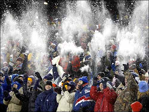
Patriots fans tossed snow in glee at Gillette Stadium after Tedy Bruschi's late interception and touchdown iced a victory over the Dolphins.
Posted on 01/22/2005 4:04:20 AM PST by SamAdams76
I thought the name Sam Adams was a representation of the "Sons of Liberty"? Oh well, I guess I am behind the times! ;)

The tractor is fueled, the fridge is full, we have a stack of DVDs to watch. We're set!
Ah, that's the life!
Hmmmmm... possible correction to my earlier report that Trenton, NJ was due for 6-10 inches. That was according to weather.com, but weather underground (wunderground.com) is predicting a -total- accumulation in my county of 12-16 inches. That's more like it!
Qwinn
Not many though. Don't move here for the politics! Nice geography, clearly 4 seasons, taxes are real high (one of the worst business climates in the USA). But still, we like it here.
It's seven below zero, cold for here, and we're supposed to get a typical snowstorm of 4-7 inches.
Family is all over Michigan, besides, sick as it sounds, I love our weather here! And nothing is as sweet as a fresh pan fried Michigan bluegil, except, maybe a pan fried Michigan Walleye!
-1 here on the shoreline of Southeastern CT. Last night our local weather dude, Jeff Fox, predicted 24-30 inches with the possibility of thunderstorms. He referred to it as a snow hurricane with winds over 60 miles an hour. Preparations underway here.
Used to live in Northern NJ. Yep, Nor'easters can produce mighty heavy snowfalls.
In GA now. A balmy 45 degress this AM Will have a high of 60. Regretfully it's going to go to the 20's tonight.
Stay safe, and have some good brandy.
Oh, one other important point to report, specific to NJ but I bet it's the same over a pretty large area:
The ground is COLD. I mean seriously, seriously cold - I've rarely seen it like this. Over 48 hours ago, we had a light dusting of snow - I don't think it could've been over half an inch total when it was done... but it's still around! It's amazing to me how long that little bit of snow has lasted on the ground. Add to that that we're not expected to get temperatures any higher than 25 degrees or so until at least Tuesday, I don't expect a single snowflake to melt for several days minimum. Expect those 6-7 feet tall banks of plowed snow along the roadsides for a few days.
Qwinn
Brunswick is at -16 and expecting 10 to 14 inches of the white stuff.
I used to keep a boat at the harbor in Waukegan - really nice harbor with great facilities. Couldn't get anything in the City with a dock. But Waukegan was great. Sold that boat and now own a classic wooden racing sailboat circa 1920 in Maine. Believe it or not, I spend more time in Maine sailing than I did in Waukegan sailing. The drive to and from Waukegan on the weekends was just too much - this was before they took out the first toll plaza on the north side and it would literally take me 5 hours to get home on a Sunday. Now, I just take the first three weeks of August off and spend them in Maine and get more sailing in than I ever did with the boat up in Waukegan. Go figure.
Hope you stay warm, sweets!
...however a sleeping bag on my back porch would probably feel better than -11 degrees!!!
Seriously, God bless you all and take all precautions....
The last time I was in anything 'close' to a frozen tundra was Chicago in December 2000.
Ended up waiting at O'Hare 10 hours to fly outta there--watched them de-ice my plane....
...I was 'this close' to kissing the tarmac when I arrived at my very steamy, humid, hot town here in Florida :))
AREA FORECAST DISCUSSION
NATIONAL WEATHER SERVICE MOUNT HOLLY NJ
415 AM EST SAT JAN 22 2005
.SHORT TERM (TODAY THROUGH SUNDAY)...
MODELS CONTINUE TO HANDLE SYSTEM WELL WITH NORTH SHORT WAVE DROPPING SOUTH RAPIDLY AND EVENTUALLY MERGING WITH THE SHORT WAVE OUT OF THE PACIFIC NW. EXTREMELY LOW TEMPS AND DPTS WILL BE SLOW TO RISE AS CLOUDS WILL SPREAD OVER FA BEFORE OR SHORTLY AFTER SUN RISE. SNOW WILL SPREAD IN RAPIDLY AND SPREAD ACROSS ENTIRE AREA. HEAVIEST SNOWS WILL BE LATE AFTERNOON INTO EARLY TONIGHT WITH RATES OF 1 TO 2 INCHES PER HOUR. AS ENERGY TRANSFERS OFF THE COAST AND THE SYSTEM DEEPENS WINDS WILL PICK UP AND DRIFTING AND BLOWING WILL ENTER THE MIX. SPEAKING OF MIX...STILL EXPECT SOME RAIN MIXING ALONG THE IMMEDIATE COAST FROM ATLANTIC COUNTY SOUTH. SNOW WILL END SUNDAY MORNING WITH DRIFTING AND BLOWING CONTINUING. TOTAL AMOUNTS OVER ARE GENERALLY 10 TO 18 INCHES.
EASTERN MONMOUTH NJ-COASTAL OCEAN NJ-
425 AM EST SAT JAN 22 2005
...WINTER STORM WARNING IN EFFECT TODAY INTO SUNDAY...
...COASTAL FLOOD WATCH FOR SUNDAY MORNING...
...STORM WARNING...
.TODAY...A CHANCE OF SNOW THIS MORNING...THEN SNOW THIS AFTERNOON. SNOW ACCUMULATION OF 6 TO 10 INCHES. WINDY WITH HIGHS AROUND 30. NORTHEAST WINDS 10 TO 15 MPH...BECOMING EAST 15 TO 25 MPH THIS AFTERNOON. WIND CHILL VALUES 1 BELOW TO 18 ABOVE ZERO.
.TONIGHT...SNOW. TOTAL SNOW ACCUMULATION OF 8 TO 12 INCHES. VERY WINDY WITH LOWS AROUND 20. EAST WINDS 15 TO 25 MPH...INCREASING TO NORTH 30 TO 40 MPH WITH GUSTS UP TO 50 MPH AFTER MIDNIGHT. LOWEST WIND CHILL READINGS 3 BELOW TO 12 ABOVE ZERO AFTER MIDNIGHT.
.SUNDAY...CLOUDY. A CHANCE OF SNOW IN THE MORNING. AREAS OF
BLOWING SNOW. STRONG WINDS WITH HIGHS IN THE MID 20S. NORTH WINDS 30 TO 35 MPH WITH GUSTS UP TO 45 MPH. CHANCE OF SNOW
50 PERCENT. WIND CHILL VALUES 5 BELOW TO 12 ABOVE ZERO.
.SUNDAY NIGHT...MOSTLY CLOUDY IN THE EVENING...THEN BECOMING
PARTLY CLOUDY. WINDY WITH LOWS AROUND 10 ABOVE. NORTHWEST WINDS 20 TO 30 MPH WITH GUSTS UP TO 40 MPH...DECREASING TO 10 TO 20 MPH WITH GUSTS UP TO 30 MPH AFTER MIDNIGHT. WIND CHILL VALUES 3 BELOW TO 7 ABOVE ZERO.
Ping. Brrrrrr.....
A few flurries are coming down here in York, PA, but the brunt is still just east of Pittsburgh.
I'm heading out in a few minutes to my 20ac garden center & nursery, down near the Md line, stock the cat up with plenty of wet/dry food and water, and will leave there after 2pm, when it's supposed to be heavily snowing.
I already have made arrangements to p/u 2 of my employees on Sunday morning, to bring in so we can begin plowing and digging the complex, out.
I'm getting too old for this crap.
Oh I love snowmobiling. You guys have a wonderful day up in the north woods. Too cool!
Just broke down and bought an OTA HD receiver, am pulling in a nice Fox signal, getting a really nice HD picture. Can't wait to see what the game looks like in HD. It'll be interesting to see how the Falcons do in the snow/cold. It doesn't bode well for our warm weather dome team to be playing a cold weather open-air team in these condidions.
For some reason, I can't get CBS in HD (for the late game). I think I'm going to go to Fry's later and get the super-duper antenna, to see if that solves the problem.
Oh, and I guess I'll have to look for some news today, to see all the DOOOOOOMED! northeasterners getting snowed in / digging out, in HD.
Hi...SamAdams76 and All FReepers in the path of this massive Storm.
I couldn't sleep all night, the Arthritis is bothering me as the Barometric pressure and temperatures drop.
OY VEY!...It's really COLD here -1 with the Wind Chill, and No White Flufy Stuff yet.
The air is very heavy and the Birds aren't chirping as usual, they know that something Bad is coming.
Will keep you posted as the day....weekend progresses as long as we have Electricity / Power that is.
PRAYING for Everyone to Stay Warm and Safe.
GOD Bless.
PS: Please PRAY for our: State Troopers, Policemen, Firemen and EMS Rescue personnel, Hospitals and their Staff...all who are in the path of this Storm...May GOD Bless and Keep them Safe.
Amen ~ and ~ Amen.
Disclaimer: Opinions posted on Free Republic are those of the individual posters and do not necessarily represent the opinion of Free Republic or its management. All materials posted herein are protected by copyright law and the exemption for fair use of copyrighted works.