Skip to comments.
La Niña is expected to continue through the Northern Hemisphere spring 2008.
NOAA Climate Prediction Center ^
| 7 February 2008
| Climate Prediction Center Internet Team
Posted on 02/08/2008 3:25:36 AM PST by justa-hairyape
EL NIÑO/SOUTHERN OSCILLATION (ENSO)
DIAGNOSTIC DISCUSSION
issued by
CLIMATE PREDICTION CENTER/NCEP
7 February 2008
Synopsis: La Niña is expected to continue through the Northern Hemisphere spring 2008.
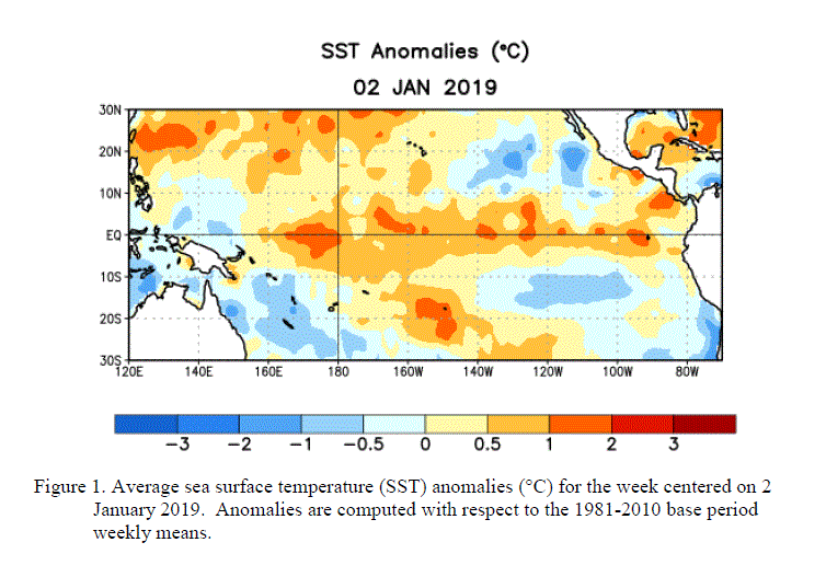
Current atmospheric and oceanic conditions indicate that La Niña has continued to strengthen in
the tropical Pacific. By the end of January 2008, equatorial SST anomalies were more than 2.0°C
below average across parts of the central and east-central equatorial Pacific.

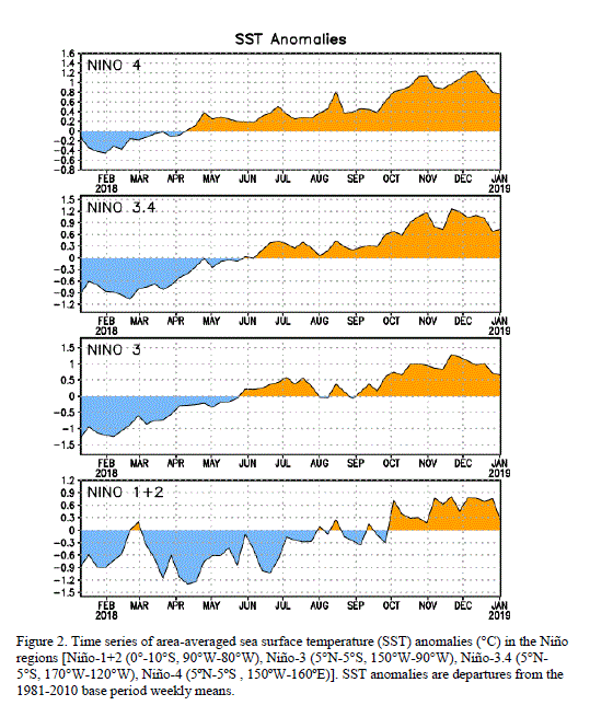
Other than the far eastern Niño-1+2 region, the magnitude of the cold anomalies in the Niño region
indices increased during the past month with the latest weekly values near -1.5°C.

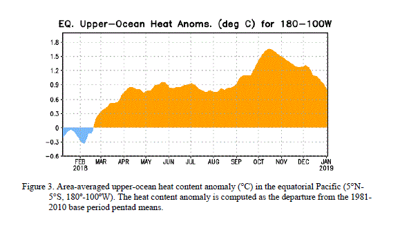
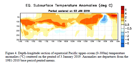
The upper-ocean heat content (average temperatures in the upper 300m of the oceans) also decreased
further during January (figure 3), and negative subsurface anomalies between -2°C to -5°C expanded
westward towards the Date Line (figure 4).


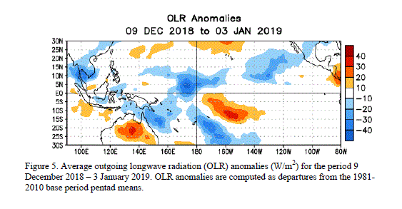
Consistent with these oceanic conditions, stronger-than-average low-level easterly and upper-level
westerly winds persisted across the central equatorial Pacific, convection remained suppressed
throughout the central equatorial Pacific, and enhanced convection covered the far western Pacific.
Collectively, these oceanic and atmospheric conditions are similar to those accompanying the last
strong La Niña episode in 1998-2000.
The recent dynamical and statistical SST forecasts for the Niño 3.4 region indicate a moderate-to-strong
La Niña through the rest of the Northern Hemisphere winter, with the likely continuation of a weaker
La Niña through April-May-June.

Thereafter, there is considerable spread in the models, with approximately one-half indicating La Niña
could continue well into the Northern Hemisphere summer. Current atmospheric and oceanic conditions
and recent trends are consistent with the likely continuation of La Niña through the Northern
Hemisphere spring 2008.
Expected La Niña impacts during February-April include a continuation of above-average precipitation
over Indonesia and below-average precipitation over the central equatorial Pacific. For the contiguous
United States, potential impacts include above-average precipitation in the Northern Rockies, the
Pacific Northwest, and the Ohio and Tennessee Valleys. Below-average precipitation is expected across
the South, particularly in the southeastern states.
This discussion is a consolidated effort of NOAA and its funded institutions. Oceanic and atmospheric
conditions are updated weekly on the Climate Prediction Center web site
(El Niño/La Niña Current Conditions and Expert Discussions).
Forecasts for the evolution of El Niño/La Niña are updated monthly in the Forecast Forum
section of CPC's Climate Diagnostics Bulletin. The next ENSO Diagnostics
Discussion is scheduled for 6 March 2008. To receive an e-mail notification when
the monthly ENSO Diagnostic Discussions are released, please send an e-mail message to:
ncep.list.enso-update@noaa.gov.
Climate Prediction Center
National Centers for Environmental Prediction
NOAA/National Weather Service
Camp Springs, MD 20746-4304
TOPICS: News/Current Events; Technical
KEYWORDS: agw; cold; globalcooling; globalwarming; lanina; noaa; weather
Navigation: use the links below to view more comments.
first 1-20, 21-40, 41-60, 61-80, 81-93 next last
This is a very important and timely prediction report from the NOAA. It was difficult to read in the format it was released on the internet. Thought I would post it here with figures embedded and open up some discussion. NOAA predictions are that the La Niña colder tropical Pacific will continue through at least the spring. If you look at the predictions however, most predict that this event will continue to September and beyond. What are the implications for experiencing an extended La Niña during a low sunspot solar cycle period ? Also, anyone have any ideas what will happen with an extended La Niña after our historic 2007/2008 winter ?
To: Beowulf; Defendingliberty; WL-law; Normandy; TenthAmendmentChampion
To: justa-hairyape
I predict higher than average denial among the Man-Made Global Warming crowd.
3
posted on
02/08/2008 3:29:29 AM PST
by
SubMareener
(Become a monthly donor! Free FreeRepublic.com from Quarterly FReepathons!)
To: SubMareener
I predict higher than average denial among the Man-Made Global Warming crowd. That is a safe prediction. Okay. We will give you that one.
To: justa-hairyape; Killing Time; Beowulf; Mr. Peabody; RW_Whacko; honolulugal; SideoutFred; ...


Data check
5
posted on
02/08/2008 3:32:52 AM PST
by
xcamel
(Two-hand-voting now in play - One on lever, other holding nose.)
To: justa-hairyape
I just hope it means a quiet 2008 hurricane season.
6
posted on
02/08/2008 3:35:08 AM PST
by
catfish1957
(Hey McLame, you can fool some of the people some of the time, but you a'int fooling any Freepers)
To: justa-hairyape
Well, I didn’t really move north in the hope that tropical temps and accompanying increased property values would soon follow...
Indeed, everything is occurring in a manner I have predicted for a few years now, based on a personal theory of a 34-year (+/-1) cycle. If I’m right, we have been in a cooling trend since about 1995 which will bottom out with the winter of 2012-13 (if you remember 1978-79, you know what I’m talking about, and it’s Not Scottish).
By 2015 I would expect to see the “next Ice Age” scare stories begin to reappear. Too late, however, as we will already be on the next upward slope.
7
posted on
02/08/2008 3:35:34 AM PST
by
ExGeeEye
(NIE or no NIE, I've been waiting since 11/04/79 to do something about Iran.)
To: justa-hairyape
In regards to figure 1, can someone explain why we have been seeing lots of moisture forming southeast of Hawaii this winter. This moisture tends to ends up traveling over Mexico and up into Texas/Southeast ? From what I have read La Nina is supposed to develop less cloud formation in the tropics and more in the Mid-Northern Pacific ?
To: justa-hairyape
Punxsytawny Phil and I predict there will be weather through the end of the year. Or maybe not.
prisoner6
9
posted on
02/08/2008 3:40:01 AM PST
by
prisoner6
(Right Wing Nuts hold the country together as the loose screws of the Left fall out.)
To: ExGeeEye
By 2015 I would expect to see the “next Ice Age” scare stories begin to reappear. Too late, however, as we will already be on the next upward slope. So I guess we could call that prediction a micro-Ice Age centered on 2012-2013 ? Let us hope such a cooling event will indeed be short. Gee, I sure wish I could afford 30 year old Scotch.
To: justa-hairyape
Weather happens. It’s been happening a lot this winter and I’m sick of it.
11
posted on
02/08/2008 3:46:13 AM PST
by
Past Your Eyes
(Bill Clinton: Life Member of the Liars' Club.)
To: catfish1957
I just hope it means a quiet 2008 hurricane season. That is a tough one. Everyone was thinking that warmer Atlantic water means more Hurricanes, but we recently saw a new report stating the opposite. The low sunspot cycle seems to be producing more water droplets in the atmosphere (new cosmic ray theory). Reference the numerous blizzards around the Northern Hemipshere. Does that mean more moisture for Hurricanes ? The Atlantic Ocean temps seem to be remaining mild and they have been keeping the southwest US and Europe relatively mild this winter. Tough prediction to make.
To: justa-hairyape
oops - they have been keeping the southwest US - should read - they have been keeping the southeast US
To: justa-hairyape
...a micro-Ice Age centered on 2012-2013...Nothing so drastic; just a cold-weather cycle.
Like the one that delayed the Normandy landings in 1944, and closed O'Hare in 1978.
34 years apart.
I'm trying to find an old post of mine that lays out my entire reasoning (so my lazy fingers don't have to retype the whole thing). Stand by...
14
posted on
02/08/2008 4:00:06 AM PST
by
ExGeeEye
(NIE or no NIE, I've been waiting since 11/04/79 to do something about Iran.)
To: justa-hairyape
Oh Boo Hoo, Oh Boo Hoo Hoo!!!!!!!!
15
posted on
02/08/2008 4:12:32 AM PST
by
Waco
To: justa-hairyape
Found it; I originally posted it a year and four days ago!
Somewhere, years ago, I read of an approximate 34-year sun cycle. It's like the sun has a pulse, my source (since forgotten) read. It has a point of high output, and a point of low output, and the extremes are about 17 years apart. My thought was well, that's interesting, lets run some numbers from recent history.
I remember the vicious winter of 1978-79. O'Hare was closed for days (at a time? or several times?). There were so many snow days at my school that there was talk of lengthening the school year (they planned for a few snow days, but they were used up quickly). It was plain nasty (if, like me, you abominate winter weather from the get-go and regard every snowflake as a personal affront-- OK, not quite that bad).
OK, I thought, let's say that was a low period in the sun's output. Let's look forward and back 17 years each way and see what we see.
17 years before was 1961, three years before I was born, so I had to ask around. To give people a reference point, I brought up the start of the Kennedy Administration. Almost uniformly, people told me it was a gorgeous year weatherwise, the sun shone brilliantly upon Inauguration Day, etc. etc.
Seventeen years the other way, 1995, I moved to Texas. I was expecting hot, and got it. However, those around me were complaining that it was unusually hot had had been getting noticeably hotter over the past couple of years. That summer, the alternator in my newish car gave up the ghost, and when I had it replaced, I was informed that they'd had a lot of those, in various makes and models, that year and it seemed to be due to the heat. I wouldn't have thought so given the temps to be found in an engine compartment, but deferred to the wisdom of the tech.
So...let's look some more.
34 years before 1978 (our benchmark for cold weather) was 1944. The summer of 1944 was known for unusual weather patterns that disrupted war planning (remember how they nearly delayed D-Day?) and the winter of '44-45 was among the coldest on record. We can thank the War Department of the era for keeping the records, again as part of the warfighting effort. My late, Michigan-born 101st Airborne uncle told me he'd never seen such an inclement season in all his years before or since, growing up on a farm in similar climate and terrain, as he saw in Bastogne in December '44...leaving aside the rain of lead and steel.
I had more hearsay data going back another two +/-34-year "solar pulses", but my memory fails me at the moment. Do recall that, on the first Earth Day (1973?) the big worry was Global Cooling and the New Ice Age, and if my theory is correct, the data from the next five years would certainly have supported that panic.
I think we are past the peak of the warm pulse (about 1995) and gradually cooling toward the next cold valley, in 2012-13.
...I'm glad to put this back at the front of my file. Should make it easier to find next time I need it.
16
posted on
02/08/2008 4:17:25 AM PST
by
ExGeeEye
(NIE or no NIE, I've been waiting since 11/04/79 to do something about Iran.)
To: ExGeeEye
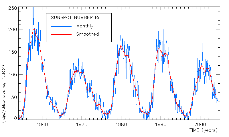
Just garbbed this sunspot cycle chart off the internet. Might be interesting to reference it as we analyze your theory.

To: justa-hairyape
To: ExGeeEye
Don't know about 1994, but your anecdotal observations correlate with the sunspot cycle in the following manner. Your cold periods occur as the sunspot cycle is increasing and your warm periods occur as the sunspot is decreasing. Again, will have to check 1944 later. This makes some sense since there will be an inherent delay and we are talking about sun intensity over time. Also the Earths vast Oceans act as temp buffers. Our Atmosphere also has some minor metrics involved. The problem right now is with the 1998 measured temperature peak. That was a couple of years later then your anecdotal observations, but statistically close.
To: justa-hairyape
Dont know about 1994 should read dont know about 1944.
Navigation: use the links below to view more comments.
first 1-20, 21-40, 41-60, 61-80, 81-93 next last
Disclaimer:
Opinions posted on Free Republic are those of the individual
posters and do not necessarily represent the opinion of Free Republic or its
management. All materials posted herein are protected by copyright law and the
exemption for fair use of copyrighted works.
FreeRepublic.com is powered by software copyright 2000-2008 John Robinson
