
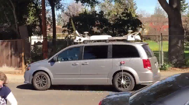
What are the LIDAR units doing on this Apple van? Photo: AppleInsider
Posted on 02/21/2015 11:59:47 PM PST by Swordmaker
The mysterious Apple minivans roaming the roads in California, Florida and elsewhere are generally assumed to be self-driving cars, but they are not. They are almost undoubtedly collecting data for maps.
They are “almost certainly a mapping vehicle,” said Paul Godsmark, chief technology officer with the Canadian Automated Vehicles Centre of Excellence, who examined photos of the mystery vehicles at Cult of Mac’s request.
Spotted around the country in recent weeks, the mysterious minivans jump-started the rumor mill with regard to a possible Apple car rolling out in the future. Since then, a steady string of reports have lent credence to the possibility that Cupertino has its eye on transforming the automotive industry just as it did with computing and mobile devices.
Godsmark is an autonomous vehicle specialist who co-founded CAVCE, a nonprofit consultancy that promotes autonomous vehicles in Canada. A civil engineer by trade, he also designed roads.
“I know about how roads are designed, built, maintained and operated,” he told Cult of Mac, adding that LIDAR mapping is becoming increasingly popular for a range of activities, from road maintenance to asset management.
Godsmark said the giveaway on the mysterious Apple vans is the placement and angle of the LIDAR gear (which he thinks to be Velodyne HDL-32E units) on the roofs of the vehicles.
LIDAR is an extremely accurate range-finding technology that bounces laser light off objects and measures the light bouncing back, hence the name, “Laser Illuminated Detection and Ranging.”
On mapping vehicles, the LIDAR units are usually mounted high, to get the necessary height for modeling, and tilted down. As the vehicle drives along the road, the LIDAR units capture a 3-D model of the road and its surroundings. It is “effectively building the model by taking slices as the vehicles moves,” Godsmark said.
He pointed to other mapping vehicles, like this TomTom vehicle with LIDAR on the back, these Mandli mapping cars and this Verus Geomatics truck, which is typical of vehicles used for asset-management purposes.
LIDAR is also used in autonomous vehicles like Google’s prototype car, but for those purposes the units are usually mounted horizontally, as in Google’s first self-driving vehicle, Bosch’s autonomous vehicle, this self-driving Land Rover and Nissan’s self-driving cars.
The LIDAR units are mounted horizontally to maximize the sensor range, Godsmark said. “I am fairly certain that the vehicle in your photo is not an autonomous one, but that it is being used for mapping,” he concluded.
Professor Ümit Özgüner, an expert in intelligent transportation systems at Ohio State University, also said the vehicles are likely being used for mapping purposes.
“There is nothing to indicate autonomous driving. The only thing you see are the sensors — LIDAR, cameras — and the GPS antenna on the top.”
“There is nothing to indicate autonomous driving,” he said. “The only thing you see are the sensors — LIDAR, cameras — and the GPS antenna on the top. So I would first say 3-D modeling/mapping is going on.”
The notion that the mysterious minivans are autonomous came from the original CBS report. Analyst Rob Enderle floated the suggestion that they were self-driving cars — because they have too many cameras! — and the idea spread from there. Subsequent reports that Apple has thousands of engineers working on project Titan added fuel to the fire.
However, autonomous cars are licensed for testing in only four states and the District of Columbia. Apple hasn’t been issued a test permit in California, where a couple of the vehicles have been spotted, according to the state’s Department of Motor Vehicles.
Why is Apple getting into detailed street-level mapping? Adding data to its Maps app is the likeliest reason. Google Maps’ Street View is a popular product, and Apple has been ramping up its mapping efforts to match those of its rival. Apple already offers photorealistic bird’s-eye views in its Map software, but nothing at street level. The mystery minivans also appear to have cameras at each corner, making this seem plausible.
However, a comprehensive mapping effort would require fleets of the vehicles, deployed all over the world. So far, the mystery vans have been spotted in a handful of states (including New York, where there’s no provision for self-driving cars), but they might be prototypes being tested before a bigger effort is launched.
There could also be other reasons for the mystery vans. Vehicles bristling with LIDAR sensors can also be used for:
Brett Davis, vice president of communications and publications at the Association for Unmanned Vehicle Systems International, declined to guess what the mysterious Apple vans are all about.
“Unfortunately we don’t have enough information on these to speculate, and we don’t want to steer you wrong,” he said. “Sorry for the pun.
If you want on or off the Mac Ping List, Freepmail me.
Apple does something ... and then the press is guessing what is going on for the next year ... :-) ...
I saw one of these yesterday on Friday in San Diego. I’ve seen Google’s vehicles before so I was sure it wasn’t one of those.
I saw one a few days ago. I figured it was google or something else. But there was no 8ft high pole camera on the van...don’t the google maps vans have that?
Got a better photo of this Apple van? From what’s shown here I saw one coming out of a condominium complex
Not quite 8 feet. . . more like about four feet above the car:

Might be a total of 8 feet counting the Subaru car.
Thanks////What I saw had the same white rack mounted up on top. The van was a small one like you show but was white, not grey
Autonomous self driving vehicles are only licensed in four states. . . and Washington DC, and Hawaii is not one of them. These cars have been spotted in New York City, Chicago, and several other National Parks. . . which would give credence to the mapping and street level arguments. . . and the 3D plans. It would also give Apple a leg up on more accurate representation on its FlyOver views in 3D, gaining accurate data on ground views and building data.
There appear to be a fleet of them. . . also adding to the mapping argument.
I am guessing that four ft camera pole on google maps street view van is passe now. That now it can be done the way Apple is doing it. Now it is less obtrusive, noticeable. I had no idea this LIDAR mapping technology was being used so widely these days by real estate firms etc etc
Any reasonably heavy user of Google Street View has seen the shadow of that many times.
They are a zero so far....They are for the future
All self-respecting Apple fanbois and fandudes are going to want one of those low slung mini-vans after Apple disposes with them after 10,000 miles. Now is the time to make inquiries. I have family that would love one. Please let me know if you try to get one and the best way to do it. I am serious!

Rob Enderle? At CBS? No wonder everybody is confused. The whole thing is just another Enderle hit/setup piece on Apple.
my first perception of said vehicle was that its roof mounted apparatus..had a striking similarity to the equipment Id seen on the Google Mobiles .
If you work or live near Google, it’s a common experience to see their mapping and driverless cars. All of the driverless cars are plainly marked as such in huge letters on the side— probably a legal requirement so you know what ran you off the road.
Disclaimer: Opinions posted on Free Republic are those of the individual posters and do not necessarily represent the opinion of Free Republic or its management. All materials posted herein are protected by copyright law and the exemption for fair use of copyrighted works.