Skip to comments.
Shasta Dam sees biggest release in decades as reservoir nears capacity
KCRA via San Francisco Chronicle ^
| February 14th, 2017
| Sarah Heise, KCRA
Posted on 02/14/2017 8:20:29 AM PST by Mariner
Water releases from Shasta Lake are at the highest in 20 years as the lake nears full capacity Monday.
The lake stood at 96 percent of capacity and 137 percent of the historical average, as of midnight Monday, according to the California Department of Water Resources.
Water officials are releasing 70,000 cubic feet per second (cfs) from Shasta Dam as the lake stands just 5 feet from the top of the reservoir, the Shasta County Sheriff's Office said.
"This is higher than it should be for this point in time," the sheriff's office said. "The release is necessary for space to allow future storms and to prevent uncontrolled release and flooding."
The reservoir holds 4,552,000 acre-feet and stood at nearly 4,400,000 acre-feet in Shasta Lake, as of early Monday morning, DWR records show.
(Excerpt) Read more at sfgate.com ...
TOPICS: Business/Economy; Government; News/Current Events; US: California
KEYWORDS: california; lakeshasta; oroville; release; reservoir; shasta; shastadam; shastalake; water
Navigation: use the links below to view more comments.
first 1-20, 21-40, 41-54 next last
This is 100 miles upstream from where the Feather River (Oroville dam) joins the Sacramento River. They will likely be at 200,000cfs by Monday.
All of this water has to pass through Sacramento and the river there is but 2ft below flood stage, with levees failing in the delta already.
1
posted on
02/14/2017 8:20:29 AM PST
by
Mariner
To: Mariner
To: Mariner
3
posted on
02/14/2017 8:23:01 AM PST
by
Mariner
(War Criminal #18)
To: Mariner
Perhaps the more appropriate question to ask here....what exactly is the weather for the next two weeks? More snow or rain?
To: Mariner
Crash on the levee mama, water’s gonna overflow.
5
posted on
02/14/2017 8:23:32 AM PST
by
MUDDOG
To: pepsionice
At least 5 inches of rain in 5 days over Shasta.
6
posted on
02/14/2017 8:25:20 AM PST
by
Mariner
(War Criminal #18)
To: MUDDOG
7
posted on
02/14/2017 8:28:39 AM PST
by
az_gila
To: FourtySeven
Is more rain expected?Yes. Lots more starting tomorrow or Thursday. The folks downstream need our prayers.
8
posted on
02/14/2017 8:29:03 AM PST
by
pgkdan
(The Silent Majority Stands With TRUMP!)
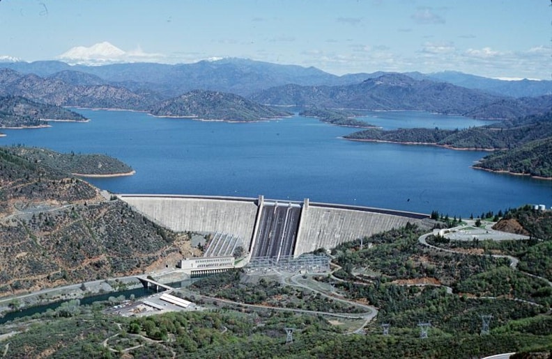
With a total capacity of 4,552,000 acre-feet, an elevation of 1,067 feet, 365 miles of mostly mountainous shoreline, and a maximum depth of 517 feet, Lake Shasta is California’s largest reservoir and the eighth largest in the United States. Lake Shasta is impounded by the Shasta Dam, a concrete arch gravity dam across the Sacramento River that stands 602 feet tall, making it the eighth tallest dam in the United States. Operated by the Bureau of Reclamation, the reservoir provides water storage, flood control, hydroelectricity, and protection against the intrusion of salt water.
9
posted on
02/14/2017 8:30:27 AM PST
by
smokingfrog
( sleep with one eye open (<o> ---)
To: Mariner
I’ve camped there when it was less than 20% full.
At least the rains are washing the last remaining poison from when the EPA killed much of the tributaries. That lake is so huge, the last 5 feet to the top may never happen. Beautiful area.
To: az_gila
Great song!
They got more experience with floods in Johnny Cash country.
11
posted on
02/14/2017 8:33:58 AM PST
by
MUDDOG
To: pgkdan
My family is pretty much near that path. My mother and brother both live just 35 miles south of the Shasta Dam, near where the Sacramento flows through the town of Red Bluff.
12
posted on
02/14/2017 8:38:41 AM PST
by
ScottinVA
( Liberals' agony is my entertainment.)
To: SparkyBass
The mountain drainage exceeds 1000 square miles.
They will have to significantly increase outflow to keep water from cresting over the top in this next storm.
13
posted on
02/14/2017 8:40:43 AM PST
by
Mariner
(War Criminal #18)
To: Mariner
 oy vey .. Murphy's having a busy week
14
posted on
02/14/2017 8:44:29 AM PST
by
tomkat
To: ScottinVA
I hope they’re in a safe place. I’ll keep them in my prayers. I have family in the area too. All Trump voters, BTW.
15
posted on
02/14/2017 8:44:33 AM PST
by
pgkdan
(The Silent Majority Stands With TRUMP!)
To: Mariner
It’s great.
Idiots thought the drought would last forever.
Always happens like this.
16
posted on
02/14/2017 8:44:37 AM PST
by
ifinnegan
(Democrats kill babies and harvest their organs to sell)
To: Mariner
17
posted on
02/14/2017 8:44:43 AM PST
by
Mariner
(War Criminal #18)
To: SparkyBass
18
posted on
02/14/2017 8:48:37 AM PST
by
Mariner
(War Criminal #18)
To: Mariner
Everything does ultimately end up in the Sacramento (I’ve been stuck in Chico for a week - while in college - when the levee at Hamilton City broke, and that storm was nothing compared to what’s going on now).
One break in one dam or levee and this will get ugly fast.
To: Mariner; All
I suppose it’s too late for these words of wisdom?
“Always drink/live upstream from the herd.”
Prayers up for smart management of this pending disaster.
So, what happens when all the water goes downstream? Will CA be back in a drought? There are no plans or places or protocols in place to deal with something like this? No additional reservoirs, lakes, ponds, etc. to hold/slow/trap this water as it moves downstream?
Oh, that’s right. In CA - Mother Government OWNS all the water. No rain barrels or flushing for YOU! ;)
20
posted on
02/14/2017 8:51:38 AM PST
by
Diana in Wisconsin
(I don't have 'Hobbies.' I'm developing a robust Post-Apocalyptic skill set!)
Navigation: use the links below to view more comments.
first 1-20, 21-40, 41-54 next last
Disclaimer:
Opinions posted on Free Republic are those of the individual
posters and do not necessarily represent the opinion of Free Republic or its
management. All materials posted herein are protected by copyright law and the
exemption for fair use of copyrighted works.
FreeRepublic.com is powered by software copyright 2000-2008 John Robinson