re: dimensions of main spillway.

Posted on 02/12/2017 4:26:47 PM PST by janetjanet998
Edited on 02/12/2017 9:33:58 PM PST by Admin Moderator. [history]
(and it took 7 hours to drop from 846.22 to 845.22)
Here is why I think it is deeper than the 20’ you speculated.
First of all, I could be wrong — ;-P
But I am basing that on the fact that all the original pictures had no reference for scale and I thought of the spillway much narrower that it is. Then I saw at the pictures with all the trucks out on it and I realized that this this has about eight gates that are 33’ each so it must be about 275’ wide or almost as wide as a football field is long.
Now when the spillway was shut down some weeks back at the start of all this we had slab out and a nice hole — looked almost manageable. Now with the last two weeks of running this spillway and what has gotten cut out below, when I look at the water cascading down in that bigger hole and running fully to the side, I bet it has cut a hole 22% of the width of the concrete I see — about a fifth as deep and the slab is wide. Well dang, that is 60’.
Maybe I am wrong but I bet it is closer than 20’
Man o’ Man this apple autocorrect is a pain in the rear.
...apple autocorrect...
I finally turned autocorrect to ‘off’
but left spellcheck turned ‘on’
works much better for me.
A few new ‘official’ pictures got posted...
It looks to me like they are rebuilding the washed-out road
from the main spillway over to the big parking lot.
http://pixel-ca-dwr.photoshelter.com/galleries/C0000OxvlgXg3yfg/G00003YCcmDTx48Y/I00000Tjj8slIgi8/KG-oroville-damage-14080-jpg
Very little water making it to the end of the main spillway.
The failure area must be huge.
(Photo taken February 24, 2017)
http://pixel-ca-dwr.photoshelter.com/galleries/C0000OxvlgXg3yfg/G00003YCcmDTx48Y/I0000HEJuP5yfNLc/KG-oroville-damage-14111-jpg
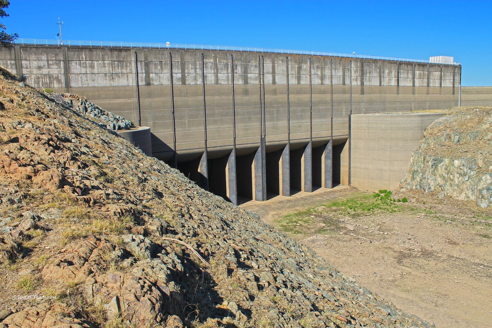
>>Important Correction: Width of Main Spillway is 178.7ft <<
The 33’ x 17’-7” construction blueprints are height and width of each “gate” instead of width and height. (note: blueprints do not specify - ordering has to be extracted from image orientation).
The 8 gates provide 140.7 feet of open waterflow width into the main spillway. There are 7 concrete-piers that separate each bay with a “double width” concrete pier in the center. With each concrete pier stated as 5 ft thick, this comes to 40 ft. However, I believe the center “double width” concrete pier is slightly less than a full 2x thickness.
This width correction stemmed from looking at the string of maintenance vehicle sizes relative to the spillway. Couldn’t get enough truck lengths to get to the inverted length width numbers.
re: dimensions of main spillway.
Thanks for the information.
Nice - thank you.
Actually, the drain tunnel is approx 4.7 miles north. The tunnel is not under the volcano. It’s under a mountain ridge near “Harry’s Ridge” - named after 84yr old “Harry Truman” who died in the May 1980 eruption. (btw- Harry was a big cat lover. He refused to leave even though the eruptions & earthquakes were getting larger in the days prior. He did admit he was getting nervous).
The “uplift in the tunnel” is interesting as it is away from the base of the volcano. There have been microquakes in the ridges North of Mt St Helens while the current elevated level of on/off swarming is going on.
http://www.cotf.edu/ete/modules/volcanoes/vtruman.html
=== excerpt
Harry Truman and His 16 Cats
Harry Truman was the friendly, 84-year-old owner of the rustic Mount St. Helens Lodge on the old south shore of Spirit Lake. The lodge was his home, and his 16 cats were like family. He had spent a lifetime on the slopes of Mount St. Helens and considered the mountain a friend. Thus, when the volcano awoke early in 1980, Harry and his cats would not leave. As spring progressed, volcanic activity grew terrifyingly violent and the Governor of the State of Washington established restricted entry zones around the mountain with the intent of evacuating everyone except a few scientists and security personnel. Even then, Harry and his cats would not leave. On Saturday afternoon, May 17, 1980, state officials tried for what turned out to be the last time to get Harry to leave. He would not go. Early the next morning, Mount St. Helens exploded. The whole north side of the mountain collapsed in a giant avalanche of rock and debris that roared across the lodge at speeds near 100 mph, obliterating the lodge and burying the site to a depth of about 50 meters. No trace was ever found of Harry or his cats.
==
Thanks ER333 for the corrected data width on the spillway. While my width was way off the point of how photographs don’t show the scale still applies I believe.
As another photo above shows, the water going into the lost gap in the spillway has eroded so much that it isn’t even making it to the end, I would still bet that the erosion has cut out a great deal in excess of the 20’ and once mucked out the fill is going to need to be 50 to 60 foot in height if they attempt to get back to original grade.
Hopefully we’ll see Harry, if not his cats, in heaven.
A few new photos have been added...
Photo showing damaged section of the main spillway:
http://pixel-ca-dwr.photoshelter.com/galleries/C0000OxvlgXg3yfg/G00003YCcmDTx48Y/I0000yYFnwfD7v7Q/KG-oroville-damage-14319-jpg
Photo taken at sunset on February 25, 2017.
-
Photo showing barges being staged closer to the damaged spillway:
http://pixel-ca-dwr.photoshelter.com/galleries/C0000OxvlgXg3yfg/G00003YCcmDTx48Y/I00002UTN7Lx9dYE/KG-oroville-damage-14258-jpg
Photo taken February 25, 2017.
Main spillway flows will be cut to zero to assess damage
FROM an Engineering Ratings Perspective, the Oroville dam is a Mind Boggling Disaster.
This Dam was designed to handle the absolute Maximum Nature could throw at it - even to events to 10,000 years in hydrological estimations (see below specs in past flood flows and the "worst case scenarios" - these are the extra safety margin factor(s)).
How Did this Dam get to this point?
The Massive Engineering Ratings/Specs are so far off in what physically transpired, this should drive hard questions that should be answered - including accountability.
What is Not Re-assuring is Workshop's put on by The California Division of Safety of Dams where "Management has instructed the engineers" to discontinue using the wording "safe" in inspection reports. (see below). Was there a culture regarding "Dam Inspections" that contributed to this situation? (see below).
The Public deserves Hard Answers, including answers on what else may have been missed. The Colossal Failure of the Actual Performance means that the Dam is facing uncertain odds if the Estimated Floods (see specs) occur before massive reconstruction... what will happen?
From CA Division of Safety of Dams: Management directing Engineers to change wording in inspection reports. Noted was "for legal protection to limit liability".
=======

=======
Mind Boggling Engineering (Ratings) Disaster: How did it come to this?

Good find; news/updates are scarce.
“... Monday, February 26 at 6:45 a.m.
the Department of Water Resources will start to close
the main spillway’s outflow down to zero cfs
and should be completed in the afternoon.
They plan to cut the flow from the main spillway
for several days to allow workers to aggressively
attack the debris pile that has accumulated down below ...”
I don’t think that the emergency spillway was really ever meant for anything but an absolute emergency. The erosion, at least downhill from the spillway, was expected.
One thing that this short flow of water did do is provide some pertinent information as to what needed to be reinforced to allow emergency operations in the future. All that hardening will allow it to be used again, at least for a while.
As for the main spillway, I think this might be an inspection/maintenance issue more than a design issue. Or maybe both. It’s apparent that the upper half to 5/8 of the spillway is pretty solid, and appears to be built on solid bedrock. Ditto for the bottom section, which while it doesn’t serve much purpose at this time, does seem to be holding up. It’s that part where it broke - where the hole first appeared - that is questionable.
Seems to me that that section was not built on solid bedrock, and was perhaps not sufficiently built up and hardened to serve the support function. Drainage issues were brought up on another web site, that a couple of the sidewall drain pipes in the vicinity of the original break were not draining water prior to the failure. This would indicate that the area was being undermined by water.
I’m partly speculating here, and partly repeating what I’ve read from others, but it seems that that part of the main spillway was inadequate.
Disclaimer: Opinions posted on Free Republic are those of the individual posters and do not necessarily represent the opinion of Free Republic or its management. All materials posted herein are protected by copyright law and the exemption for fair use of copyrighted works.