Free Republic
Browse · Search
News/Activism
Topics · Post Article

Skip to comments.

Louisiana Loses Its Boot (Interesting Pictures)
Matter ^ | 9-8-2014 | Brett Anderson

Posted on 09/18/2014 11:58:52 AM PDT by blam

The boot-shaped state isn’t shaped like a boot anymore. That’s why we revised its iconic outline to reflect the truth about a sinking, disappearing place.

By Brett Anderson
September 8, 2014
Photographs by William Widmer
Illustrations by Matthew Woodson

Early this year, I drove from Arnaudville, Louisiana, to Morgan City, hoping to walk where I’d heard there was land.

Arnaudville is in Cajun country, in the southern part of the state. Morgan City is roughly halfway between Lafayette and New Orleans, if you take the Highway 90 route. Directionally speaking, that’s all I knew.

I was aware Arnaudville is just outside Lafayette, but I couldn’t have told you in what direction, even though I’d been there several times before. Compulsive use of my smart phone’s map apps has eroded whatever navigational confidence — and, by extension, awareness — I ever possessed of areas outside New Orleans, where I’ve lived for over a dozen years. And this part of Cajun country can be disorienting. Boats traverse rice fields flooded in winter for crawfish production, and the slow-running bayous look innocuous until you get trapped on the wrong side of one. In Arnaudville, I met a tourist from Arkansas who, upon entering the tasting room at Bayou Teche Brewing, announced, “We tried to Google this place and ended up in a muddy swamp by the levee over there.”

I was gearing up to feel a variation on that pain myself as I made my way from Arnaudville to Morgan City. It was the first in a planned season of road trips during which I’d compare the facts on the ground in coastal Louisiana with the facts as presented by the official state maps produced by government agencies. Paper maps.

(snip)

(Excerpt) Read more at medium.com ...


TOPICS: News/Current Events
KEYWORDS: louisiana; maps; mississippiriver; subsidence
Navigation: use the links below to view more comments.
first previous 1-2021-4041-6061-67 next last
To: crusty old prospector

>> Blame the levees.

And what happened to all the federal (tax) dollars given to LA for coastline engineering???


21 posted on 09/18/2014 12:18:26 PM PDT by Gene Eric (Don't be a statist!)
[ Post Reply | Private Reply | To 2 | View Replies]

To: knarf
I think it was Karl's machine


22 posted on 09/18/2014 12:19:42 PM PDT by BBell (I'm cynical and sarcastic and therefore I love Ann Coulter)
[ Post Reply | Private Reply | To 7 | View Replies]

To: crusty old prospector

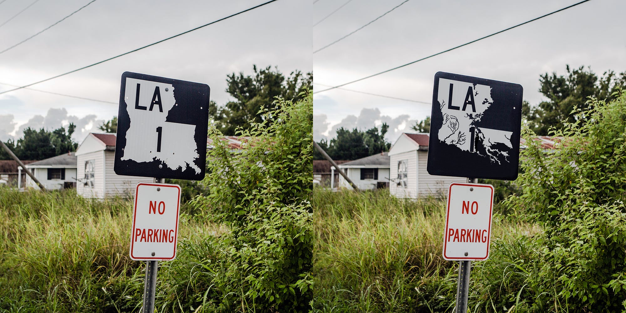
Hmm. Interesting pictures. I am no expert here, but something seems wrong. In both pictures, the background is identical, the picture taken angle is exact, the pole with the sign hasn’t changed angle, etc..

Unless the pictures taken were within just a couple of minutes from each other, I would have still expected some of the following.

The clouds would have changed between pictures, even just a little. The time of day doesn’t seem to have changed. The lighting hasn’t changed, nor the shadows.

Also, by changing the sign, I would have expected some modification to the pole angle, even accidental would have done something to it. But more specifically, I would think that the installer would have tried to straighten the pole.


23 posted on 09/18/2014 12:22:20 PM PDT by ForYourChildren (Christian Education [ RomanRoadsMedia.com - a Classical Christian Approach to Homeschool ])
[ Post Reply | Private Reply | To 2 | View Replies]

To: bicyclerepair

‘I question the intelligence of anyone who lives below sea level.’

I don’t think they could manage it without the gov/tax payers funding their levees, pumps & other major infrastructure.


24 posted on 09/18/2014 12:22:28 PM PDT by Fantasywriter (Any attempt to do forensic work using Internet artifacts is fraught with pitfalls. JoeProbono)
[ Post Reply | Private Reply | To 12 | View Replies]

To: blam

The picture is photoshopped.
The background matches too well in both pictures.


25 posted on 09/18/2014 12:23:00 PM PDT by toast
[ Post Reply | Private Reply | To 1 | View Replies]

To: toast
The background matches too well in both pictures.

Indeed. Check the clouds. Did they "beam" in a new sign?

26 posted on 09/18/2014 12:27:37 PM PDT by Bloody Sam Roberts (EveryoneÂ’s got a plan Â’til they get punched in the mouth.)
[ Post Reply | Private Reply | To 25 | View Replies]

To: blam

The Gulf Coast has been SUBSIDING for decades. One subdivision in Baytown sunk below water level, while the water level remained constant. Same with some condos in the Seabrook area.

Global warming enthusiasts say it is rising waters, but the water levels have not risen significantly in the last decades. Add hurricanes and floods along the Mississippi which open up the delta and you have more open waters and mud flats.


27 posted on 09/18/2014 12:27:41 PM PDT by rstrahan
[ Post Reply | Private Reply | To 1 | View Replies]

To: BBell

oops ... yeah ... yer right


28 posted on 09/18/2014 12:27:42 PM PDT by knarf (I say things that are true .. I have no proof .. but they're true.)
[ Post Reply | Private Reply | To 22 | View Replies]

To: bicyclerepair
I question the intelligence of anyone who lives below sea level.

Death Valley comes to mind. Same sentiment, different reason...

29 posted on 09/18/2014 12:30:15 PM PDT by HiJinx (4 Terrorists Arrested Crossing Border in Texas)
[ Post Reply | Private Reply | To 12 | View Replies]

To: dfwgator

Hahahaha! Very good sir!


30 posted on 09/18/2014 12:32:54 PM PDT by spankalib ("I freed a thousand slaves. I could have freed a thousand more if only they knew they were slaves.")
[ Post Reply | Private Reply | To 4 | View Replies]

To: blam

Wonderful article.

As a Louisiana born (New Iberia) ex-native, it saddens me greatly to see such a wonderful wetland succumb to folks who think they can change nature.

However, given the NFL grade mosquitoes, 99+% relative humidity, and politics which are close to Obama-level corrupt, I tell folks that Louisiana is a great place to be FROM.


31 posted on 09/18/2014 12:34:58 PM PDT by Da Coyote
[ Post Reply | Private Reply | To 1 | View Replies]

To: blam
Wonder if anyone recognizes this state.


32 posted on 09/18/2014 12:35:41 PM PDT by cripplecreek ("Moderates" are lying manipulative bottom feeding scum.)
[ Post Reply | Private Reply | To 3 | View Replies]

To: crusty old prospector
Blame the levees.

Exactly. The levees prevent silt from reaching the wetlands. The wetlands dies and salt water advances.

33 posted on 09/18/2014 12:36:48 PM PDT by FatherofFive (Islam is evil and must be eradicated)
[ Post Reply | Private Reply | To 2 | View Replies]

To: cripplecreek

Toucan Sam ?


34 posted on 09/18/2014 12:38:28 PM PDT by fieldmarshaldj (Resist We Much)
[ Post Reply | Private Reply | To 32 | View Replies]

To: blam
Is Texas still shaped like heaven?

We should get to the important things first.

35 posted on 09/18/2014 12:46:33 PM PDT by Scoutmaster (I'd rather be at Philmont)
[ Post Reply | Private Reply | To 1 | View Replies]

To: TexasCajun

Wow, the salt domes and the French land patterns along the rivers really jumps out at you. I think I saw Boudreaux and Thibadeaux out there on their pirou.


36 posted on 09/18/2014 12:51:10 PM PDT by centurion316
[ Post Reply | Private Reply | To 9 | View Replies]

To: blam

This is BS propaganda!

The shoreline has been eroding for generations, but it does NOT look anything at all like that. If it did, Interstate 10 would have replaced the Ponchartrain Causeway as the world's second longest bridge.

Check the Google image link above and see what it actually looks like. The "boot" has lost a toe or two, but this is total eco-propaganda crap.
37 posted on 09/18/2014 12:58:31 PM PDT by caligatrux (...some animals are more equal than others.)
[ Post Reply | Private Reply | To 1 | View Replies]

To: cripplecreek

The State of Depression?


38 posted on 09/18/2014 12:58:51 PM PDT by Cowboy Bob (They are called "Liberals" because the word "parasite" was already taken.)
[ Post Reply | Private Reply | To 32 | View Replies]

To: caligatrux; blam
but it does NOT look anything at all like that.

Yup, pretty damn silly map.
According to it, I should be underwater and here I sit 15' above sea level with the road in front my house (La. Hwy 1) at 20' above sea level.

39 posted on 09/18/2014 1:09:02 PM PDT by The Cajun (Ted Cruz, Sarah Palin, Mark Levin, Mike Lee, Louie Gohmert....Nuff said.)
[ Post Reply | Private Reply | To 37 | View Replies]

To: The Cajun

LOL, I was thinking about all my friends whose houses would be in the Gulf of Mexico if that map were even close to correct.


40 posted on 09/18/2014 1:15:01 PM PDT by caligatrux (...some animals are more equal than others.)
[ Post Reply | Private Reply | To 39 | View Replies]


Navigation: use the links below to view more comments.
first previous 1-2021-4041-6061-67 next last

Disclaimer: Opinions posted on Free Republic are those of the individual posters and do not necessarily represent the opinion of Free Republic or its management. All materials posted herein are protected by copyright law and the exemption for fair use of copyrighted works.

Free Republic
Browse · Search
News/Activism
Topics · Post Article

FreeRepublic, LLC, PO BOX 9771, FRESNO, CA 93794
FreeRepublic.com is powered by software copyright 2000-2008 John Robinson