Skip to comments.
CNN Exclusive: Analysis shows 2nd possible Indian Ocean path for Malaysia airliner (Likely crash)
CNN ^
| 03/14/2014
| By Barbara Starr. Michael Pearson and Jethro Mullen
Posted on 03/14/2014 2:39:13 PM PDT by SeekAndFind
A classified analysis of electronic and satellite data, conducted by the United States and Malaysian governments, calculates Malaysia Airlines Flight 370 likely crashed into the Indian Ocean on one of two possible flight paths, CNN has learned.
One flight path suggests the plane crashed into the Bay of Bengal off the coast of India, and the other has it traveling southeast and crashing in the Indian Ocean, according to the analysis.
Yet another theory is taking shape about what might have happened to missing Malaysia Airlines Flight 370: Maybe it landed in a remote Indian Ocean island chain.
The suggestion -- and it's only that at this point -- is based on analysis of radar data revealed Friday by Reuters suggesting that the plane wasn't just blindly flying northwest from Malaysia. And it's just one of untold theories floating around about what might have happened to the airliner, which disappeared a week ago without leaving much of a trace of where it had gone or why.
(Excerpt) Read more at cnn.com ...
TOPICS: Foreign Affairs
KEYWORDS: malaysiaairlines
Navigation: use the links below to view more comments.
first previous 1-20, 21-40, 41-60, 61-67 last
To: henbane

It looks like an overall summary of
what's been discussed here at Free Republic dot com.
But what is of use to me is
this statement towards the end of his article.
" A satellite was able to pick up a ‘ping’ from the plane until 08:11 local time,more than seven hours after it lost radar contact,
although it was unable to give a precise location.
Mr Razak went on to say that based on this new data, investigators ‘have determined the plane’s last communication with a satellite was in one of two possible corridors –north from the border of Kazakhstan and Turkmenistan through to northern Thailand,
and south from Indonesia to the southern Indian Ocean. "
Now take that information and
the arc ping map along with the jet route map, and you can find possible links.
We find
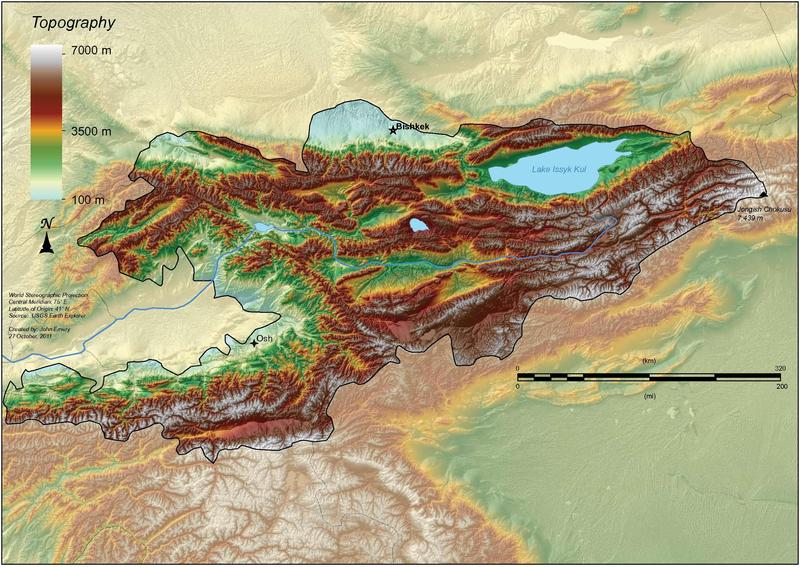
BISHKEK MANAS,
Kyrgyzstan and Manas has a 13,800-foot long runway, built for Soviet bombers.
That led to some interesting possibilities.
61
posted on
03/16/2014 4:42:22 PM PDT
by
Yosemitest
(It's Simple ! Fight, ... or Die !)
To: Yosemitest
Excellent sources here and good pin-pointing.
Your Global Security link leads to this key info:
The United States has started the withdrawal from an airbase in Kyrgyzstan that serves as the main transit hub for NATO forces in Afghanistan, the Pentagon said in a statement on 18 October 2013.
In 2011, Kyrgyz President Almazbek Atambayev announced plans to shut the base down by 2014, when the NATO-led International Security Assistance Force (ISAF) is to be pulled out of Afghanistan.
He signed a bill ordering the closure of the base into law in June 2013. It stipulates that US forces must abandon the base at Manas International Airport, near the capital Bishkek, by July 2014.
Wonder what shape Manas International is in right now?
Here's a link that shows the extent of this search for abandoned airfields as well as active ones.The zoom & drag feature is particularly helpful.
Malaysia Airlines Flight 370: Runways in Range
62
posted on
03/16/2014 10:00:55 PM PDT
by
henbane
To: henbane
But IF he did land at Manas International Airport, that would mean that the U.S. military knows about it, and is keeping it secret.
With that many families in the "need to know", it just doesn't make sense for the U.S. military to keep it secret.
That would make me not worry about some outcomes, but more worried about others, such as the “highly suspicious” cargo load and the rumors of "a ton of gold".
I have a distant friend that was part of the U.S. advance set-up crew that went into Manas, and was tasked to be one of the "last out" as part of the "tear-down/mop-up" crew.
He said it can get dangerously cold up there this time of year.
That would have been at the very edge of Malaysia Airlines Flight 370's fuel supply and with all the rerouting he had done at the start and the changes in altitude, it's just about "out of reach" for him.
63
posted on
03/17/2014 2:09:55 AM PDT
by
Yosemitest
(It's Simple ! Fight, ... or Die !)
To: henbane
Take a look at this.
Someone sent me another piece of information you should read.
" Someone on another thread posted a link to a theory that the missing 777 used SIA68 (Singapore Airlines flight 68) to cloak their own airplane until they could get across the Indian Ocean, away from primary radar.
http://keithledgerwood.tumblr.com/post/79838944823/did-malaysian-airlines-370-disappear-using-sia68-sq68 "
That's a really good theory.
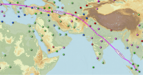
But there's problems when you try to match it with the
the arc graph (click on it for more detailed info) that shows the estimated range of the aircraft with it's remaining fuel IF it was flying at its MAXIMUM SPEED or 7 hours 30 minutes of fuel.
Now, from the article:
this statement towards the end of his article." A satellite was able to pick up a ‘ping’ from the plane until 08:11 local time,more than seven hours after it lost radar contact,
although it was unable to give a precise location.
Mr Razak went on to say that based on this new data, investigators ‘have determined the plane’s last communication with a satellite was in one of two possible corridors –north from the border of Kazakhstan and Turkmenistan through to northern Thailand,
and south from Indonesia to the southern Indian Ocean. "
My problem is ~ I don't know how accurate that Red Arc map is,
and I don't know whether to trust it or not.
I've been trying to match up the numbers on a "guess-ta-mated" flight path.
You can narrows down the search area if you take all the Satellite "Handshakes" into consideration for the search of runways/landing strips that Malaysia Airlines Flight 370 could have landed on.
The Way Point on the northwet side of her screen is "IGREX" on Jet Route "P628" where the heading changes to a more northerly direction 320 degrees to PORT BLAIR Navaid.
That's a total airborne time of about 4 hours 40 minutes from takeoff.
The arc graph shows the estimated range of the aircraft with it's remaining fuel IF it was flying at its MAXIMUM SPEED or 7 hours 30 minutes of fuel.
Now, from the article:
this statement towards the end of his article." A satellite was able to pick up a ‘ping’ from the plane until 08:11 local time,more than seven hours after it lost radar contact,
although it was unable to give a precise location.
Mr Razak went on to say that based on this new data, investigators ‘have determined the plane’s last communication with a satellite was in one of two possible corridors –north from the border of Kazakhstan and Turkmenistan through to northern Thailand,
and south from Indonesia to the southern Indian Ocean. "
That's
7 hours and 31 minutes after takeoff.
"... The plane departed for an overnight flight from Kuala Lumpur to Beijing at 12:40 a.m. on March 8.
Its communications with civilian air controllers were severed at about 1:20 a.m., and the jet went missing ... "
That leaves
2 Hours 50 minutes to travel from "IGREX" on Jet Route "P628 to an undefined point on that arc of 7 hours 30 minutes from takeoff.
Let's say that the pilot leans the engines out to get the most out of his fuel for distance with the remaining time for "IGREX" and gets 3 hours if time,
before he hits his 20 minutes safety margin on fuel and then starts to burn his 1 hour emergency fuel.
At maximum speed of Mach 0.89 (590 mph, 950 km/h, 512 knots) at a cruise altitude of 35,000 ft , that would
allow him 1770 miles of distance (to the red arc), before hitting his reserves.
Let's
assume that since he stayed on the Jet Routes, he continued to stay on the Jet Routes.
Now take that information and
the arc ping map (important to view this map at this link for more details) along with the jet route map, and you can find possible links.
Now I run the numbers on the Jet Routes starting from "IGREX" on Jet Route "P628" and starting
subtotaling for a target of 1770 Nautical Miles.Take a look from
SkyVector.com.
Jet Route P628 NW IGREX 151 NM to Port Blair
Port Blair 272 NM to VATLA
VALTA 173 NM to URKOK
URKOK 172 NM to KAGUL
KAGUL 51 NM to DORIL
DORIL 99 NM to OPASA
OPASA 75 NM to IKINA
IKINA 28 NM to OPONI
OPONI 121 NM to ASOPO or JABALPUR
-----------
1,142 NM subtotal
---------------
Change route to W66 North to KHAJURAHO
ASOPO 97 NM to KKJ
Change route to W40 NNE via KANPUR to LUCKNOW
KJJ 72 NM to IGONA
IGONA 28 NM to LUCKNOW
Change route to M890 Northwest to SARSAWA
LUCKNOW 87 NM to JALABAD
JALABAD 65 NM to PUMOT
PUMOT 116 NM to SARAWA
--------------
1,607 NM Subtotal
SARAWA 27 NM to ONOGI
ONOGI 26 NM to CHANDIGARH (CHG)
CHG 73 NM to LAKET
LAKET 49 NM to SAMAR
Change Direction North to J220 to SIALKOT (SLT) Airport
SAMAR aprx 75 NM to SIALKOT Airport
------------------
1,857 NM
Now A different Route
From M890 at SARSAWA
--------------
1,607 NM Subtotal
Change route to W39 North to LEH
SARAWA 143 NM to LELAX
LELAX 101 NM to LEH
------------
1,851 NM Subtotal
Change route, direct to HOTAN approximately 030 heading
LEH approx 145 NM to HOTAN
Change Route, via SHACHE via KASHI
HOTAN apx 150 NM to SHACHE approx 310 heading
SHACHE 68 NM via A364 to KASHI
Change Route NNW via TADOT to BISHKEK MANAS
KASHI 100 NM to TADOT approximately 350 heading
TADOT 100 NM to BISHKEK MANAS Airport, Kyrgyzstan
--------------
2,414 NM Total (might be out of range)
==============================================
My Airport of Interest are:UDHAMPUR (VIUX)
Runway [18 36] 9028.8 x 148 ft, Asphalt
Sialkot International Airport (IATA: SKT, ICAO: OPST)
Runway 22/04 11811 x 148 ASP
GILGIT (OPGT) Gilgit, Gilgit-Baltistan, Pakistan
Runway [07 25] 5385.6 x 98 ft, Asphalt
Runway 09 / 27 1003.2 x 49 ft / 306 x 15 m
Skardu Airport Pakistan (OPSD), IATA: KDU
Runway: 14/32 11944 Ft x 100 Ft ASP
Runway: 15/33 6501 Ft x 101 Ft ASP
======================
I think our educated guesses after putting the pieces together, are getting better.
64
posted on
03/17/2014 4:42:14 PM PDT
by
Yosemitest
(It's Simple ! Fight, ... or Die !)
To: Yosemitest
Anyone know at what angle of southern latitude would the engines stop sending the handshake data to satellites?
65
posted on
04/05/2014 5:15:45 AM PDT
by
ryan33
To: ryan33
Not to my knowledge.
The last I heard was 40 degrees off the satellite, which only gives a circle oln the globe.
66
posted on
04/05/2014 1:41:06 PM PDT
by
Yosemitest
(It's Simple ! Fight, ... or Die !)
To: ryan33
CORRECTION:
The last I heard was 40 degrees off the satellite, which only gives a circle on the globe.
67
posted on
04/05/2014 1:42:15 PM PDT
by
Yosemitest
(It's Simple ! Fight, ... or Die !)
Navigation: use the links below to view more comments.
first previous 1-20, 21-40, 41-60, 61-67 last
Disclaimer:
Opinions posted on Free Republic are those of the individual
posters and do not necessarily represent the opinion of Free Republic or its
management. All materials posted herein are protected by copyright law and the
exemption for fair use of copyrighted works.
FreeRepublic.com is powered by software copyright 2000-2008 John Robinson