
Posted on 05/19/2006 9:50:02 PM PDT by NormsRevenge
It's crazy these things are still going.
At first they said something like 90 days.
The egg-heads that designed and built these kicked-ass!
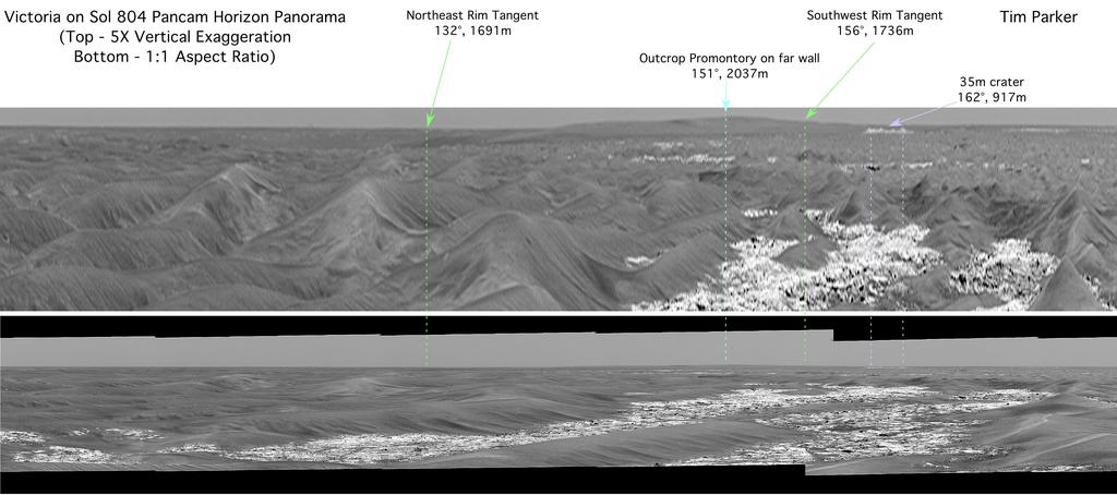
Stretched View Showing 'Victoria'
This pair of images from the panoramic camera on NASA's Mars Exploration Rover Opportunity served as initial confirmation that the two-year-old rover is within sight of "Victoria Crater," which it has been approaching for more than a year.
Engineers on the rover team were unsure whether Opportunity would make it as far as Victoria, but scientists hoped for the chance to study such a large crater with their roving geologist. Victoria Crater is 800 meters (nearly half a mile) in diameter, about six times wider than "Endurance Crater," where Opportunity spent several months in 2004 examining rock layers affected by ancient water.
When scientists using orbital data calculated that they should be able to detect Victoria's rim in rover images, they scrutinized frames taken in the direction of the crater by the panoramic camera. To positively characterize the subtle horizon profile of the crater and some of the features leading up to it, researchers created a vertically-stretched image (top) from a mosaic of regular frames from the panoramic camera (bottom), taken on Opportunity's 804th Martian day (April 29, 2006).
The streched image makes mild nearby dunes look like more threatening peaks, but that is only a result of the exaggerated vertical dimension. This vertical stretch technique was first applied to Viking Lander 2 panoramas by Philip Stooke, of the University of Western Ontario, Canada, to help locate the lander with respect to orbiter images. Vertically stretching the image allows features to be more readily identified by the Mars Exploration Rover science team.
The bright white dot near the horizon to the right of center, labeled "Outcrop Promontory," (barely visible without labeling or zoom-in) is thought to be a light-toned outcrop on the far wall of the crater, suggesting that the rover can see over the low rim of Victoria. The northeast and southeast rims are labeled in bright green. Finally, the light purple lines and arrow highlight a small crater.
Image credit: NASA/JPL-Caltech/MSSS/Cornell University
Waste of Money Update: It's still just rust.
Must be winter time on Mars.
Just last night I thought about these little guys and meant to Google to see if they were still alive.
Remarkable.
I go to the site every day. Looking forward to the next lander which is at the pole then in a couple of years another rover.
LOL!

Could be some rock layers near the rim, but otherwise it looks like it has very steep sides and there's no way in. It also looks like it's featureless sand all the way from just below the rim to the dunes at the bottom. But that could be due to poor resolution in the photo. Hope it makes it though. It'll be worth a closer view.
I'll be curious what kind of resolution the newly arrived MRO will provide..
hopefully Opportunity will be able to get some good shots of the outcrops
The High Resolution Imaging Science Experiment camera consists of a 0.5 meter reflecting telescope, the largest of any deep space mission, and has a resolution of 1 microradian, or 0.3 meter at a height of 300 km. (For comparison purposes, satellite images of Earth are generally available to a resolution of 0.1 meter, and satellite images on Google Maps are available to 1 meter.[8]) It can image in three color bands, 400-600 nm (blue-green or B-G), 550-850 nm (red) and 800-1,000 nm (near infrared or NIR).Not too shabby! :-)
This is so ... astounding! Think of it, some folks are taking virtual trips on Mars, the planet Mars, not some studio set, the real MARS! It must be the pinnacle of a life's study and preparation. I applaud the scientists ... wow, just WOW!
The atmospheric pressure is so low there that water's boiling and freezing points are very close together. It would appear that what we have with Mars is a very dead planet.
These little guy's have become ho-hum, a side-story. Yet they are a great American feat.
It should be, since MRO partnered with the National Reconnaissance Office - the spy satellite guys. :-)
Ping
Thank you. I'm kind of proud of the fact that I designed some of the hardware and wrote some of the software for the inertial measurement units used in the Rovers.
Disclaimer: Opinions posted on Free Republic are those of the individual posters and do not necessarily represent the opinion of Free Republic or its management. All materials posted herein are protected by copyright law and the exemption for fair use of copyrighted works.