Posted on 10/16/2010 9:44:20 PM PDT by ErnstStavroBlofeld
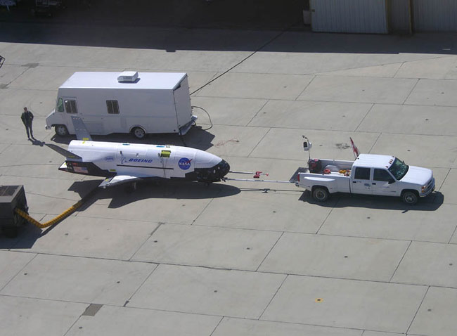
After six months in orbit, the U.S. Air Force X-37B UOV (unmanned orbital vehicle) is proving elusive to amateur astronomers. This international collection of sky watchers have proved remarkably adept at spotting orbital objects in the past, including classified ones like the X-37B. One notable incident occurred two years ago, when a U.S. spy satellite fell out of orbit (apparently because of a failure in its maneuvering system). The amateur astronomers were able to track it. If this had not been an American reconnaissance satellite, there would have been no media attention to this, because 4-5 satellites a month fall back to earth. Since most of the planet is ocean, or otherwise uninhabited (humans tend to cluster together), the satellites tend to come down as a few fragments, rarely is anyone, or anything man-made, hit. Before the Internet became widely used a decade ago, you heard very little about all these injured or worn out space satellites raining down on the planet. But with the Internet, the many thousands of amateur astronomers could connect and compare notes. It was like assembling a huge jigsaw puzzle. Many sightings now formed a pattern, and a worldwide network of observers made visible the movements of hundreds of space satellites. These objects were always visible at night, sometimes to the naked eye, but unless you knew something about orbits and such, they could be difficult to keep track of. These days, a lot of the activity is posted and discussed at http://www.satobs.org/. But the X-37B has proved elusive, and has become a frustrating challenge to the amateur sky watchers. This is pleasing to American air force officials, who designed the X-37B to be elusive to terrestrial observation
(Excerpt) Read more at strategypage.com ...
Ping.
So they painted it flat black.
Only on the bottom half.
Good. Question is can it be tracked via radar or lidar or infrared, etc.
It actually landed back in late July, that is why nobody can see it.
The news would have leaked to the aviation buffs if it landed
FarScape 1
LLS
http://spaceweather.com/flybys/?PHPSESSID=93v4muakmgjr99b25qskbmomh7
enter your zip to find the times
Satellite Rise time Direction to look Transit time Max elevation Magnitude
ISS 05:55:42 am WNW 05:58:08 82° -4.0 (very bright)
X-37B 06:03:40 am WSW 06:06:40 35° 3.4 (dim)
CZ-4B R/B 06:30:12 am NNE 06:33:40 61° 1.3 (visible)
Satellite Rise time Direction to look Transit time Max elevation Magnitude
X-37B 05:08:33 am SSE 05:11:38 30° 3.7 (dim)
ISS 06:21:43 am W 06:23:49 29° -2.2 (very bright)
CZ-4B R/B 06:38:05 am NNE 06:42:06 76° 1.1 (visible)
GOCE (flaring satellite) 07:21:23 pm SSW 07:23:23 29° 4.8 (dim)
Satellite Rise time Direction to look Transit time Max elevation Magnitude
ISS 05:16:12 am ESE 05:18:37 37° -2.7 (very bright)
XSS-11 05:19:13 am S 05:23:29 74° 4.1 (dim)
X-37B 05:45:48 am SSW 05:48:04 26° 4.0 (dim)
CZ-4B R/B 06:45:59 am N 06:50:00 86° 1.0 (bright)
GOCE (flaring satellite) 07:16:56 pm S 07:19:01 35° 4.4 (dim)
Disclaimer: Opinions posted on Free Republic are those of the individual posters and do not necessarily represent the opinion of Free Republic or its management. All materials posted herein are protected by copyright law and the exemption for fair use of copyrighted works.