Free Republic
Browse · Search
General/Chat
Topics · Post Article

Skip to comments.

Did YOU know that Africa is three times larger than China? Fascinating maps reveal the [tr]
UK Daily Mail ^ | February 16, 2017 | Naomi Leach

Posted on 02/16/2017 9:29:02 AM PST by C19fan

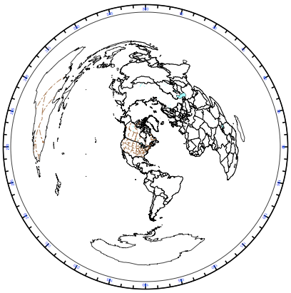
While some are aware that 2D maps fail to accurately convey the scale of countries and continents on Earth, a mind-boggling new infographic reveals the true extent of this distortion.

Historically, Mercator projection used in 2D cartology was favoured by sailors as it allowed them to keep their course - but this system is flawed. The further away destinations are from the equator the more distorted their size becomes.

(Excerpt) Read more at dailymail.co.uk ...


TOPICS: History; Science
KEYWORDS: maps
Navigation: use the links below to view more comments.
first 1-2021-22 next last
/src on/The Mercator projection is racist./src off/
1 posted on 02/16/2017 9:29:02 AM PST by C19fan
[ Post Reply | Private Reply | View Replies]

To: C19fan

Just wish I could find my WHOGIVESAFLYINGRATSASS punch card.


2 posted on 02/16/2017 9:33:08 AM PST by laweeks
[ Post Reply | Private Reply | To 1 | View Replies]

To: C19fan

A continent is larger than a country? Wow.


3 posted on 02/16/2017 9:36:52 AM PST by Ray76 (DRAIN THE SWAMP)
[ Post Reply | Private Reply | To 1 | View Replies]

To: C19fan

You mean - as we were told in school in the 50s and 60s - Africa the Sleeping Giant, that was someday going to solve all the world’s problems? Meh.


4 posted on 02/16/2017 9:39:22 AM PST by oh8eleven (RVN '67-'68)
[ Post Reply | Private Reply | To 1 | View Replies]

To: C19fan

A stunning NEW Development in Human Knowledge!


5 posted on 02/16/2017 9:40:20 AM PST by Paladin2 (No spellcheck. It's too much work to undo the auto wrong word substitution on mobile devices.)
[ Post Reply | Private Reply | To 1 | View Replies]

To: C19fan

Actually pretty interesting.

No matter what, attempting to flatten a 3D object into 2D causes issues.


6 posted on 02/16/2017 9:55:23 AM PST by Flick Lives
[ Post Reply | Private Reply | To 1 | View Replies]

To: Paladin2

And Africa is having a hard time feeding itself due to corruption. The Chinese seem to be the only ones able to deal with it and start up new AG projects in Africa.


7 posted on 02/16/2017 9:55:43 AM PST by Oldexpat
[ Post Reply | Private Reply | To 5 | View Replies]

To: C19fan

I didn’t click through to the article, but did someone mention to the breathless headline writer that there are these odd things called ‘globes’ that people can see in museums, let alone in libraries, schools, living rooms, etc.?


8 posted on 02/16/2017 9:57:25 AM PST by Zeppo ("Happy Pony is on - and I'm NOT missing Happy Pony")
[ Post Reply | Private Reply | To 1 | View Replies]

To: C19fan
Neat, thanks.

I remember years ago talking to a FReeper from England who was telling me how (impressively) big Great Britain was....he said, that from the tip in the south to the tip north of Scotland the distance was 610 miles.

I told him that when I travel west on I-10 and cross into Texas from Louisiana there's a sign that says El Paso, 857 miles.

I also told him that when you get to El Paso, you're still in Texas.

Never heard from him again.

9 posted on 02/16/2017 9:58:16 AM PST by blam
[ Post Reply | Private Reply | To 1 | View Replies]

To: C19fan

Africa is a continent. China is a country.


10 posted on 02/16/2017 10:04:33 AM PST by AlaskaErik (I served and protected my country for 31 years. Progressives spent that time trying to destroy it.)
[ Post Reply | Private Reply | To 1 | View Replies]

To: C19fan
So the map on my cube wall which show Australia is much bigger than North and South America combined is wrong?


11 posted on 02/16/2017 10:17:16 AM PST by KarlInOhio (a government contract becomes virtually a substitute for intellectual curiosity - Pres. Eisenhower)
[ Post Reply | Private Reply | To 1 | View Replies]

To: blam

I can fit 4 Great Britains in Alberta.


12 posted on 02/16/2017 11:00:07 AM PST by Jonty30 (What Islam and secularism have in common is that they are both death cults)
[ Post Reply | Private Reply | To 9 | View Replies]

To: oh8eleven
You mean - as we were told in school in the 50s and 60s - Africa the Sleeping Giant, that was someday going to solve all the world’s problems?

Everyone should have a globe representation of Earth, shows the true size of continents and countries. A lot of people don't realize most of Africa is above the equator, with it running through Kenya. Europe looks like a tiny little thing in the far north. Washington is at about the same latitude as Turkey. Much of Europe up above where Canada is.

13 posted on 02/16/2017 11:03:13 AM PST by roadcat
[ Post Reply | Private Reply | To 4 | View Replies]

To: C19fan
Countries Of The World By Area

Russia is the largest country in the world.
It contains Lake Baikal which is the oldest, largest, clearest and deepest fresh water lake in the world.

14 posted on 02/16/2017 11:27:11 AM PST by blam
[ Post Reply | Private Reply | To 1 | View Replies]

To: C19fan

This is stupid. China is a country. Africa is a continent. Sheesh. Is our public education system really this bad?


15 posted on 02/16/2017 12:06:29 PM PST by Inkie
[ Post Reply | Private Reply | To 1 | View Replies]

To: KarlInOhio
So the map on my cube wall...is wrong?

New York City as center of the Earth?

16 posted on 02/16/2017 2:09:30 PM PST by JimRed ( TERM LIMITS, NOW! Building the Wall! TRUTH is the new HATE SPEECH.)
[ Post Reply | Private Reply | To 11 | View Replies]

To: KarlInOhio

2D maps are drawn to show how the world looks from that vantage point. Depending on your vantage point, any continent on the map can increase or decrease in size. So a map that has North America as a central point will show North America being larger than it really is, when compared to other continents.

If they use a map that has Africa as a central point, North America shrinks considerably.


17 posted on 02/16/2017 2:33:28 PM PST by Jonty30 (What Islam and secularism have in common is that they are both death cults)
[ Post Reply | Private Reply | To 11 | View Replies]

To: Jonty30
With an azimuthal equidistant projection like I posted, the central point is most accurate with increasing distortion towards the edge. The one single point opposite the center gets turned into a circle with a circumference of about 80,000 miles.

It accurately shows the distance and direction from the center to anywhere on Earth, but there is a price to pay for that.

18 posted on 02/16/2017 2:45:55 PM PST by KarlInOhio (a government contract becomes virtually a substitute for intellectual curiosity - Pres. Eisenhower)
[ Post Reply | Private Reply | To 17 | View Replies]

To: C19fan

Folks in the Inner City might want to do that Country Comparison ...

Some folks actually think that they come from a Country called Africa


19 posted on 02/16/2017 6:08:46 PM PST by TexasTransplant (They used to get away with it. Not anymore.)
[ Post Reply | Private Reply | To 1 | View Replies]

To: blam

Wow Blam, ya did it again, I keep adding things on to my Bucket List because of you.

I want to catch a Fish out of Lake Baikal

Keep it up, I may never die, I have too many things left to do!

Thanks again


20 posted on 02/16/2017 6:15:42 PM PST by TexasTransplant (They used to get away with it. Not anymore.)
[ Post Reply | Private Reply | To 14 | View Replies]


Navigation: use the links below to view more comments.
first 1-2021-22 next last

Disclaimer: Opinions posted on Free Republic are those of the individual posters and do not necessarily represent the opinion of Free Republic or its management. All materials posted herein are protected by copyright law and the exemption for fair use of copyrighted works.

Free Republic
Browse · Search
General/Chat
Topics · Post Article

FreeRepublic, LLC, PO BOX 9771, FRESNO, CA 93794
FreeRepublic.com is powered by software copyright 2000-2008 John Robinson