
Posted on 07/01/2008 7:01:42 AM PDT by cogitator
Learn something new every day entry: this image and accompanying article (click the source link above) told me about Nea Kameni, which is in the Santorini lagoon and which had volcanic activity in 1950. I never knew the name of the island and that it was recently active until yesterday.
Click for full-size.
Here's a view taken from Santorini.

And this image is just to put everything into proper perspective.
** ping **
You can certainly tell from the satellite photo from which direction the prevailing winds blow.
How do you determine that?
As air rises, it's ability to hold water vapor reduces. So, moisture laden air at sea level that suddenly bumps into a mountain rises. As it rises, temperature falls and pressure falls causing the air to no longer carry the amount of moisture it did at lower elevations and releases it as clouds and rain. As a result, the windward (upwind) side of mountains tend to be greener than the leeward (downwind). A meteorologist can provide a more detailed explanation but that's the gist of it.
This isn't necessary what has happened to cause the northeastern side to be so much breener than the other sides but that would be my first guess.
One of my favorite places on Planet Earth (though I wouldn’t want to own real estate there).
Friendly people, good weather most of the year and good wine. Whe only bad part about the whole island is the influx of overweight, over age German women who beach themselves on the nude beaches around the island - when Brunhilda drops he top and flops down on the sand you don’t want to be around (Greenpeace, where are you when we need you). My advice, stay inland on warm days.
The hi-res image leaves out the most interesting parts of the island from an archaeological point of view.
My question is, was the image ‘shopped? I don’t think I’ve ever seen the harbor without at least one cruise ship or ferry?
How did those two explosions compare with the one that created Crater Lake?
Sobering that all all in “historical” times. The Indians have legends about Crater Lake. Krakatoa was in modern times, the Minoean explosion was recorded by observers.
Beautiful photos again and again!! I don’t know how you find them but please keep them up.
Hail Atlantis!
I have some rocks that a friend picked up for me on Thera. She put them in a bag that says “Greetings from Atlantis”.
That picture looks like Godzilla about ready to have a polar bear for lunch...
Now that you mention it, it does.
Our Parish organist went on a cruise to Santorini in late May. He said it was one of the most beautiful places he’d ever seen.
 |
||
| · join · view topics · view or post blog · bookmark · post new topic · | ||
|
|
|||
Gods |
Thanks cogitator. |
||
|
· Mirabilis · Texas AM Anthropology News · Yahoo Anthro & Archaeo · · History or Science & Nature Podcasts · Excerpt, or Link only? · cgk's list of ping lists · |
|||
the Minoean explosion was recorded by observers.The only Theran eruption noted in surviving ancient records refers to an eruption circa 200 BC.
read later
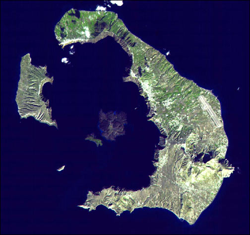
One of the largest volcanic eruptions in the past 10,000 years occurred in approximately 1620 BC on the volcanic island of Santorini in the Aegean Sea. This astronaut photograph illustrates the center of Santorini Volcano, located approximately 118 kilometers to the north of Crete (not shown). Prior to 1620 BC, the island of Santorini, now known as Thera, was built up by layers of lava created by overlapping shield volcanoes, and it had experienced three significant eruptions that formed overlapping calderas, or collapsed magma chambers. Around 1620 BC, the fourth (and latest) major eruption created the present-day islands and caldera bay of Santorini Volcano. The caldera rim is clearly visible in this image as a steep cliff forming the western shoreline of the island of Thera.
Following the 1620 BC eruption, much of the previous island of Santorini was destroyed or submerged; this event may have been the inspiration for the legend of the “lost continent” of Atlantis. Far from legend however, many archeologists believe that the eruption was a major factor—or the immediate cause—of the destruction of the classical Minoan civilization of Crete.
The white rooftops of cities and towns trace the caldera rim on the island of Thera, and overlook the young central islands of Nea Kameni and Palaea Kameni, which both formed from lava domes and flows that started erupting approximately 1,400 years after the cataclysmic 1620 BC event. Several of these flows are visible in the image as brown to dark-brown irregular masses forming Nea Kameni (image left). The most recent volcanic activity in the Kameni islands occurred in 1950, and included some small explosions and production of lava. The extent of development, and location of an airport (image upper right) on Thera illustrate the popularity of Santorini Volcano as a tourist destination. Today, volcanic activity is closely monitored by the Institute for the Study and Monitoring of the Santorini Volcano, or ISMOSAV.
Astronaut photograph ISS017-E-5037 was acquired April 19, 2008 with a Kodak 760C digital camera using an 800 mm lens, and is provided by the ISS Crew Earth Observations experiment. The image was taken by the Expedition 17 crew, and is provided by the Image Science & Analysis Laboratory, Johnson Space Center. The image in this article has been cropped and enhanced to improve contrast. Lens artifacts have been removed. The International Space Station Program supports the laboratory to help astronauts take pictures of Earth that will be of the greatest value to scientists and the public, and to make those images freely available on the Internet. Additional images taken by astronauts and cosmonauts can be viewed at the NASA/JSC Gateway to Astronaut Photography of Earth. Caption by William L. Stefanov, NASA-JSC.
Sorry for the slow reply. There's a couple of references to the Mazama eruption volume, basically ranging from 30-56 square km of ash. The Santorini "upgrade" I referenced put it at ~60. So the comparison ranges from roughly comparable to 2x for Santorini. Krakatoa is generally considered to have been around 18. Pinatubo was 10.
Here's a good little table. Tambora more accurately (as much as that's possible) is more like 130 than 100.
Santorini is a fun place. The colors of the volcanic tuffa and ash are extraordinary. To this day, pumice washes up in the shore with each wave.
Disclaimer: Opinions posted on Free Republic are those of the individual posters and do not necessarily represent the opinion of Free Republic or its management. All materials posted herein are protected by copyright law and the exemption for fair use of copyrighted works.