Airborne laser surveys may help narrow the many theories that attempt to explain the origins of grassy mounds that dot Southwest Washington.
Posted on 04/06/2009 10:06:39 AM PDT by BGHater
Mima Mounds: Scientists say new laser maps suggest glaciers as the architects of the mysterious humps, but one gopher proponent holds firm.
From goofy to erudite, more than three dozen theories have attempted to explain the origins of grassy mounds that dot the prairies of Southwest Washington. The latest twist won't settle the debate, but it casts the mysterious hummocks in a different light.
Laser light, that is.
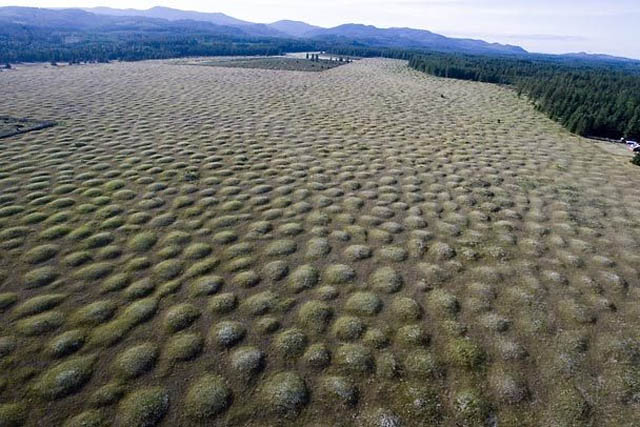
Scientists used airborne laser surveys to create topographic maps that reveal new details about the so-called Mima Mounds scattered across lowlands south of Olympia and Tacoma. The technique fires 23,000 pulses a second toward the ground, and erases signals that bounce back from vegetation and buildings. The result is an exceptionally crisp image accurate to a few inches or feet.
The new maps clearly show that all of the mounds formed near the margins of retreating glaciers, supporting an idea first proposed nearly a century ago, said Robert Logan, chief of geological mapping for the Washington Department of Natural Resources.
Logan and Timothy Walsh, who leads DNR's geologic-hazards section, tweaked the old theory to fit their new observations. They presented their work in Seattle last week at the 81st annual meeting of the Northwest Scientific Association.
Fans of the gopher theory aren't buying it — but more about that later.
Airborne laser surveys may help narrow the many theories that attempt to explain the origins of grassy mounds that dot Southwest Washington.

 Light distance and ranging (LIDAR) uses laser pulses to generate detailed topographic maps. This image shows a portion of the mounded prairie south of Mima Mounds Natural Area Preserve.
(Excerpt) Read more at seattletimes.nwsource.com ...

I imagine that they got a lot more information from the LIDAR than “the mounds formed near the edges of the glaciers”. One look at that highway map with the red blobs showing the various mound locations tell you that.
Although this was the government.
ping
Mima Mounds In The Kenya HighlandsMima Mounds are rarely reported outside the western United States. But Kenya has them, too. At elevations of 1500-3600 meters on Mt. Kenya, fields of mounds up to 6 meters in diameter and 1.5 meters high have been described. Cox and Gakahu have studied some of these African mounds and find them much like the North American Mima Mounds. They are found well above the range of the rhizomyid mole rat, a rodent similar to the North American pocket gopher in size and behavior. Quantitative measurements indicate the mounds to be constructed from dirt immediately surrounding the mounds. In short, the African mounds and probably those of North America seem to be the products of industrious rodents.
by William R. Corliss
Science Frontiers
No. 33: May-Jun 1984
(Cox, George W., and Gakahu, Christopher G.; "The Formation of Mima Mounds in the Kenya Highlands: A Test of the Dalquest-Scheffer Hypothesis," Journal of Mammalogy, 65:149, 1984.)Earthquakes And Mima MoundsIn a recent paper in Nature, P.B. Umbanhower et al described how they created regular geometric patterns in a layer of fine particles (only 0.15 mm in diameter) spread on a vibrating surface. At various forcing frequencies, they saw the layer of tiny brass spheres heap up into hexagonal honeycombs, circular piles, and even stranger shapes.
by William R. Corliss
Science Frontiers
No. 108: Nov-Dec 1996
(Umbanhower, Paul B., et al; "Localized Excitations in a Vertically Vibrated Granular Layer," Nature, 382: 793, 1996)
Comment. Nothing anomalous here, you say? Quite right, but perhaps there is in this experiment an explanation of a long-recognized geological anomaly: The origin of the famed Mima Mounds found scattered by the thousands in various regions of the planet, such as Mima Prairie near Puget Sound, in Washington State.
Actually, the demonstration of Umbanhower et al was preceded by a similar experiment back in 1990. In that year, A.W. Berg reported in Geology how he had covered a piece of plywood with a thin layer of fine sand (loess) and subjected the plywood sheet to impacts simulating earthquakes. Lo and behold, the sand rose up in an array of Mima Mound-like heaps. (See: SF#69 and p. 201 in the book Science Frontiers. This book is described here.
Umbanhower, a physicist, probably doesn't read Geology, but the results of his team's experiments certainly confirm Berg's simpler experiments and support the idea that quakes molded the Mima Mounds.
 |
||
| · join · view topics · view or post blog · bookmark · post new topic · | ||
|
|
|||
Gods |
Thanks BGHater. |
||
|
· Discover · Nat Geographic · Texas AM Anthro News · Yahoo Anthro & Archaeo · Google · · The Archaeology Channel · Excerpt, or Link only? · cgk's list of ping lists · |
|||
The Cycle of Cosmic Catastrophes:
Flood, Fire, and Famine
in the History of Civilization
by Richard Firestone,
Allen West, and
Simon Warwick-Smith
After seeing them first hand, I’m inclined to disagree. Too geometric. Way, way, way too uniform to be formed by trillions of gallons of water in a hurry!
Many years ago I was a wilderness Ranger in the Rockies. I discovered a place where a creek ran through a narrow crevasse. There was a mini glacier there that formed an ice bridge across the creek. The cool thing was that in the summer, the creek thawed a high enough tunnel so a person could walk in. The roof looked like an inside-out golf ball, much like those mounds look. So i think there is a chance that melting glaciers may have had something to do with it.
Sandy: I want you to kill every gophers on the golf course!
Carl Spackler: Correct me if I'm wrong Sandy, but if I kill all the golfers, they're gonna lock me up and throw away the key...
Sandy: Not golfers, you great fool! Gophers! The *little* *brown*, *furry* *rodents* -!
Carl Spackler: We can do that; we don't even have to have a reason. All right, let's do the same thing, but with gophers -!
WA ping
In earlier times, the flat plain was a mountainside and the area in question was a mogul field

Say WA? Evergreen State ping
Quick link: WA State Board
FReepmail sionnsar if you want on or off this ping list.
Ping sionnsar if you see a Washington state related thread.
The missoula floodway was in Eastern Washington... these are on the West side of the mountains, and I don’t think were part of that.
Disclaimer: Opinions posted on Free Republic are those of the individual posters and do not necessarily represent the opinion of Free Republic or its management. All materials posted herein are protected by copyright law and the exemption for fair use of copyrighted works.